


 Deutsch
 Nederlands
Astberg Trail

Varied beginner trail round between the Kaiser towns of Ellmau and Going.
Wanderstartplatz Tourismus Info, Ellmau
Wanderstartplatz Tourismus Info, Ellmau
Jogging
Easy
10,2 km
520 Elevation gain
We are sorry, your requested page is not available. You can start a new search on this page!
Varied beginner trail round between the Kaiser towns of Ellmau and Going.
Wanderstartplatz Tourismus Info, Ellmau
Wanderstartplatz Tourismus Info, Ellmau
Jogging
Easy
10,2 km
520 Elevation gain

Crystal-clear mountain lake and magnificent views of the Wilder Kaiser’s western summits
Hintersteiner See, Scheffau (890 m)
Hintersteiner See, Scheffau (890 m)
Hiking
Easy
1:30 h
5,2 km
130 Elevation gain

Explore the sunny foot of the Pölven mountain.
Cross-country skiing
Easy
0,9 km

The circuit around Going is a lengthy and demanding tour with a great variety of different sections.
Tourist Information Office, Going (766 m)
Tourist Information Office, Going (766 m)
Jogging
Intermediate
1:25 h
11,2 km
280 Elevation gain

From Going to the Astberg with a small altitude loop & impressive panoramic view.
Hiking starting point Going center (former tourist information Going) (764 m)
Hiking starting point Going center (former tourist information Going) (764 m)
Hiking
Easy
3:30 h
8,6 km
560 Elevation gain

A running circuit from Scheffau towards Ellmau via the Auwald district.
Starting point Scheffau Tourist Information Office (752 m)
Starting point Scheffau Tourist Information Office (752 m)
Jogging
Easy
7,7 km
180 Elevation gain

This 3-part Via Ferrata features a rope bridge and an extremely difficult exit option.
Via ferrata
Length160,0 m

Over snow-covered meadows along the Goinger Sonnseite
Bathing lake, Going (742 m)
Bathing lake, Going (742 m)
Hiking
Easy
1:30 h
3,9 km
60 Elevation gain

A wild and romantic walk through the Kaiserwald forest with its wildlife park and cosy, traditional Tirolean parlour.
Hiking starting point Tourist Info, Ellmau (800 m)
Hiking starting point Tourist Info, Ellmau (800 m)
Hiking
Intermediate
3:30 h
9,0 km
300 Elevation gain

Pleasant high-altitude walk taking in the mountain and Astbergsee lake - the mirror of the Wilder Kaiser!
Blattlalm, Going (1,246 m)
Blattlalm, Going (1,246 m)
Hiking
Easy
0:40 h
1,7 km
80 Elevation gain

The Pramarunde circuit - a scenically beautiful circuit at all times of the year
Tourist Information Office, Going (766 m)
Tourist Information Office, Going (766 m)
Jogging
Easy
0:30 h
4,4 km
70 Elevation gain

A walk that lets you experience the Brandstadl mountain and leads you to Jochstubnsee lake.
Brandstadlbahn valley station, Scheffau (681 m)
Brandstadlbahn valley station, Scheffau (681 m)
Hiking
Easy
4:45 h
12,7 km
1130 Elevation gain

The best seat in the house for a view of the Wilder Kaiser!
Tourist Information Office, Going (766 m)
Tourist Information Office, Going (766 m)
Cycling
Intermediate
2:00 h
7,5 km
350 Elevation gain

Stripsenjochhaus – Stripsenkopf – Feldberg – Scheibenbichlalmen – Griesenau – Gasteig
Stripsenjochhaus, St. Johann in Tirol (1,577 m)
Gasteig (750 m)
Hiking
Intermediate
6:30 h
16,1 km
640 Elevation gain

circuit tour with breathtaking panorama
Astberg Bergstation
Astberg Bergstation
Hiking
Easy
1:20 h
4,1 km
140 Elevation gain

Short, crisp connection between the Blattlloipe and the Schwendterloipe.
Cross-country skiing
Intermediate
0,5 km
30 Elevation gain

A beautiful bike tour with moderate and short climbs araound the striking Pölven mountain.
anywhere along the tour
anywhere along the tour
Cycling
Easy
29,6 km
420 Elevation gain

Ellmau Tourist Information Office - football pitch - Ellmauer Hof - KaiserBad - Hausbach farms - Ellmau Tourist Information Office
Tourist Information Office, Ellmau (820 m)
Tourist Information Office, Ellmau (820 m)
Cycling
Easy
8,2 km
110 Elevation gain

Number of rope lengths12
Access time2,0
Alpine climbing route
Multi-rope length difficulty levels3+
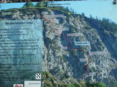
Geöffnet
Via ferrata
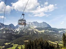
The highlight for everyone who loves hiking for pleasure - lush Alpine meadows, sparkling mountain lakes and delightful food in the Kitzbühel Alps. And the Bergbahnen Wilder Kaiser - Brixental summer cable cars make the ascent and descent easy.
Astberg, Going
Hochsöll
Hiking
Easy
6:45 h
20,0 km
720 Elevation gain

Number of rope lengths6
Access time2,0
Alpine climbing route
Multi-rope length difficulty levels6+
This short and easy valley circuit takes you around the village of Going am Wilden Kaiser and past the bathing lake, a delightful spot to cool off in fine weather.
Hiking starting point Going center (former tourist information Going) (764 m)
Hiking starting point Going center (former tourist information Going) (764 m)
Hiking
Easy
1:00 h
6,4 km
110 Elevation gain

Imperial glide during the day and at night - on the only night trail.
Cross-country skiing
Easy
1,2 km
30 Elevation gain

Enjoy snowy forests and nature in winter.
Hiking starting point Tourist Info, Scheffau (738 m)
Hiking starting point Tourist Info, Scheffau (738 m)
Hiking
Easy
1:45 h
3,8 km
170 Elevation gain

Going church square - Bergdoktor practice Ellmau and Gruberhof Söll. This e-bike tour gives you a chance to enjoy the magnificent mountain panorama at the foot of the Wilder Kaiser and takes you past the three main filming locations of the “Der Bergdoktor” (The Mountain Doctor) TV series.
Going church square
Going church square
Cycling
Intermediate
51,0 km
990 Elevation gain

Up for a wild witch’s ride? Day and night: off you go!
Cable car valley station, Söll (725 m)
Cable car valley station, Söll (725 m)
Tobogganing
Intermediate
3,0 km

The best seat in the house for a view of the Wilder Kaiser!
Hiking starting point Going center (former tourist information Going) (764 m)
Hiking starting point Going center (former tourist information Going) (764 m)
Hiking
Easy
2:15 h
5,8 km
290 Elevation gain

mountain station Salvistabahn / Kleine Salve
Middle station Salvistabahn Itter
Hiking
Intermediate
2:45 h
7,4 km
360 Elevation gain

Moderate tour to the Schleier Waterfall, a great outdoor experience.
Tourist Info, Going (764 m)
Tourist Info, Going (764 m)
Cycling
Intermediate
6,6 km
410 Elevation gain

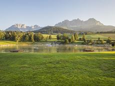
Is it about the journey or the destination? Well, one of the destinations of this stage is definitely the Hintersteiner See lake and its views. Surrounded by stunning mountain vistas, dwarf pine scrubland and beech forests, the lake is one of the cleanest and most beautiful mountain lakes in Tirol. The private pristine gem covers 56 hectares and measures 36 metres at its deepest point. With this picture-perfect backdrop, hikers will complete the remaining distance to the Kaindlhütte hut in no time.
Gaudeamushütte
Hintersteiner See
Hiking
Intermediate
6:30 h
15,1 km
888 Elevation gain

Enjoy the scenic area of the Hohe Salve where the Söll waters originate.
Exit Keat chairlift, Söll (1,533 m)
Exit Keat chairlift, Söll (1,533 m)
Hiking
Intermediate
3:45 h
10,3 km
530 Elevation gain

Going, Hüttling – Graspoint-Niederalm – Obere Regalm – Brennender Palven – Gaudeamushütte – Klamml – Gruttenhütte
Hiking starting point Hüttling, Going (820 m)
Gaudeamushütte, Going (1,263 m) / Gruttenhütte, Ellmau (1,620 m)
Hiking
Intermediate
4:30 h
8,0 km
1120 Elevation gain

Number of rope lengths9
Access time2,0
Alpine climbing route
Multi-rope length difficulty levels5

Ellmau Tourist Information Office - golf course - Wochenbrunner Alm
Tourist Information Office, Ellmau (800 m)
Wochenbrunner Alm, Ellmau (1,085 m)
Cycling
Intermediate
4,8 km
260 Elevation gain

Hartkaiserbahn summit station - Ellmis Zauberwald - Tanzbodensee lake - Hartkaiserbahn summit station
Hartkaiser summit station, Ellmau (1,555 m)
Hartkaiser summit station, Ellmau (1,555 m)
Jogging
Easy
3,4 km
120 Elevation gain

All routes of the competitions Kaiserkrone Trail - the imperial trail running event in Scheffau am Wilden Kaiser!
Jogging
Difficult
115,0 km
8460 Elevation gain

Experience culinaric highlights for the whole family.
Bergstation Rabennest (1.150 m)
Bergstation Rabennest (1.150 m)
Hiking
Easy
0:40 h
1,7 km
90 Elevation gain

Baumgartenköpfl (Bergsteigergrab) – Wilder-Kaiser-Steig – Jubiläumssteig – Gruttenhütte
Brennender Palven (1,572 m)
Gruttenhütte, Ellmau (1,620 m)
Hiking
Difficult
2:30 h
3,3 km
410 Elevation gain

Onto the Hausberg mountain with panoramic views of the Wilder Kaiser and Hartkaiser mountains and back via the Ranhartalm.
Hiking starting point Tourist Info, Ellmau (800 m)
Hiking starting point Tourist Info, Ellmau (800 m)
Hiking
Easy
8:00 h
22,8 km
1020 Elevation gain