

Winter walking
Aschauer Sonnseit winter circuit
Closed
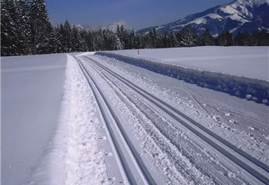
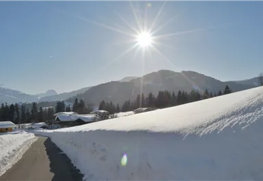
Across snow-covered meadows along the Going 'sunny side' (Sonnseite).
3,90 km
60 m
01:30 h


Route
3,90 km
60 m
01:30 h
758 m
Starting Point
Bathing lake, Going (742 m)
End Point
Bathing lake, Going (742 m)
What to do in an emergency? Call emergency number
140 - Mountain Rescue (Bergrettung)
112 - European Emergency Number
133 - Police
144 - Ambulance
Many routes have rescue points at the hiking signs, which can be used as a clear location identification in an emergency.
The Alpine Club provides tips for optimal preparation for mountain hiking.
SOS-EU-Alp App
The SOS EU ALP app allows you to determine your location (x,y coordinates) via your smartphone. In an emergency, this location data can be sent directly to the responsible control center (Tyrol, South Tyrol or Bavaria).
Important Information
Description
From now on, follow the groomed winter hiking trail on the left (parallel to the cross country track 'Aschauerloipe') until you reach the Aschauerweg. Once there, turn right and walk southwards for approx. 50 metres (parallel to the paved road). You can take a short break at the Koasastadl, then turn right onto the winter hiking trail. Accompanied by the sun, you hike once again through the district of Schattenried next to...
Best Season
Jan
Feb
Mar
Apr
May
Jun
Jul
Aug
Sep
Oct
Nov
Dec
Skill Level
Endurance
Family-friendly
Loop tour
More information at: www.wilderkaiser.info/mobility
Heading from Wörgl or Kufstein on the B178 road, take the Going Prama exit before you reach the Stanglwirt hotel. When you reach the first junction, turn right in the direction of the bathing lake. Keep following the road and make another right turn towards the bathing lake after approx. 400 m. The car park is located on the right-hand side.
Camping and permanent parking is prohibited on this car park.


Current Weather
Today
2026-05-20
Morning
7 °C
Afternoon
8 °C
Evening
7 °C
Tomorrow
2026-05-21
Morning
6 °C
Afternoon
9 °C
Evening
9 °C
Friday
2026-05-22
Morning
9 °C
Afternoon
13 °C
Evening
12 °C
Saturday
2026-05-23
Morning
12 °C
Afternoon
15 °C
Evening
14 °C
Sunday
2026-05-24
Morning
13 °C
Afternoon
16 °C
Evening
14 °C
Monday
2026-05-25
Morning
13 °C
Afternoon
16 °C
Evening
15 °C
Tuesday
2026-05-26
Morning
14 °C
Afternoon
17 °C
Evening
15 °C
Wednesday
2026-05-27
Morning
15 °C
Afternoon
18 °C
Evening
16 °C
Thursday
2026-05-28
Morning
15 °C
Afternoon
18 °C
Evening
16 °C
Friday
2026-05-29
Morning
14 °C
Afternoon
17 °C
Evening
13 °C
Saturday
2026-05-30
Morning
12 °C
Afternoon
13 °C
Evening
11 °C
Sunday
2026-05-31
Morning
10 °C
Afternoon
12 °C
Evening
11 °C
Monday
2026-06-01
Morning
10 °C
Afternoon
12 °C
Evening
10 °C
Tuesday
2026-06-02
Morning
11 °C
Afternoon
13 °C
Evening
11 °C
Last updated at 05/20/2026, 02:00 AM
Contact
Contact
You have questions? We are happy to assist you.


