

Mountainbike tour
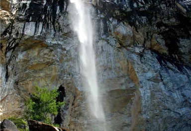
MTB Tour Schleier Waterfall
Moderate tour to the Schleier Waterfall, a great outdoor experience.
Medium
6,60 km
410 m


Route
6,60 km
410 m
70 m
1117 m
Starting Point
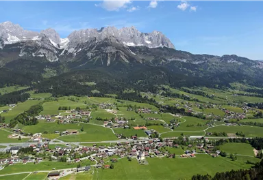
Tourist Info, Going (764 m)
End Point
Tourist Info, Going (764 m)
What to do in an emergency? Call emergency number
140 - Mountain Rescue (Bergrettung)
112 - European Emergency Number
133 - Police
144 - Ambulance
Many routes have rescue points at the hiking signs, which can be used as a clear location identification in an emergency.
The Alpine Club provides tips for optimal preparation for mountain hiking.
SOS-EU-Alp App
The SOS EU ALP app allows you to determine your location (x,y coordinates) via your smartphone. In an emergency, this location data can be sent directly to the responsible control center (Tyrol, South Tyrol or Bavaria).
Description
Start this moderately difficult mountain bike tour at the Hiking Starting Point in the center of Going (opposite GoingSport) and follow the village road to the Raiffeisen Bank. There, turn left and after the underpass turn right onto Pramaweg. The road leads past meadows and houses in the direction of the Going bathing lake.
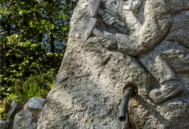
At the junction of Kapellenweg and Aschauerweg, keep left and follow Aschauerweg uphill to the Hüttling car park. Here you have the opportunity to refresh yourself at the fountain and visit the Aschinger Chapel.
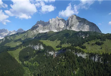
Afterwards, the forest road leads mostly through woodland to just below the Schleierwasserfall waterfall....
Best Season
Jan
Feb
Mar
Apr
May
Jun
Jul
Aug
Sep
Oct
Nov
Dec
Skill Level
Endurance
Heading from St. Johann on the B178 road, take the first exit to Going and drive through the town until you see the Tourist Info and the hiking starting point on the left-hand side after crossing the bridge.
Current Weather
Today
2026-02-21
Morning
-2 °C
Afternoon
-2 °C
Evening
-2 °C
Tomorrow
2026-02-22
Morning
1 °C
Afternoon
3 °C
Evening
4 °C
Monday
2026-02-23
Morning
1 °C
Afternoon
2 °C
Evening
3 °C
Tuesday
2026-02-24
Morning
3 °C
Afternoon
5 °C
Evening
5 °C
Wednesday
2026-02-25
Morning
6 °C
Afternoon
9 °C
Evening
8 °C
Thursday
2026-02-26
Morning
7 °C
Afternoon
9 °C
Evening
7 °C
Friday
2026-02-27
Morning
5 °C
Afternoon
7 °C
Evening
6 °C
Saturday
2026-02-28
Morning
2 °C
Afternoon
4 °C
Evening
3 °C
Sunday
2026-03-01
Morning
1 °C
Afternoon
3 °C
Evening
2 °C
Monday
2026-03-02
Morning
1 °C
Afternoon
3 °C
Evening
3 °C
Tuesday
2026-03-03
Morning
-1 °C
Afternoon
5 °C
Evening
4 °C
Wednesday
2026-03-04
Morning
2 °C
Afternoon
4 °C
Evening
3 °C
Thursday
2026-03-05
Morning
2 °C
Afternoon
2 °C
Evening
2 °C
Friday
2026-03-06
Morning
1 °C
Afternoon
2 °C
Evening
2 °C
Contact
Contact
You have questions? We are happy to assist you.


