

Hiking tour
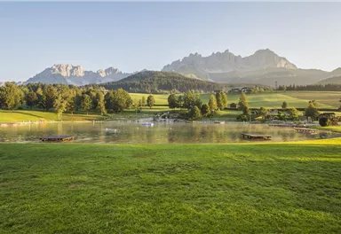
Bathing lake circular walk
This short and easy valley circuit takes you around the village of Going am Wilden Kaiser and past the bathing lake, a delightful spot to cool off in fine weather.
Easy
6,40 km
110 m
01:00 h
Easy
Route
6,40 km
110 m
01:00 h
771 m
Starting Point
Hiking starting point Going center (former tourist information Going) (764 m)
End Point
Hiking starting point Going center (former tourist information Going) (764 m)
What to do in an emergency? Call emergency number
140 - Mountain Rescue (Bergrettung)
112 - European Emergency Number
133 - Police
144 - Ambulance
Many routes have rescue points at the hiking signs, which can be used as a clear location identification in an emergency.
The Alpine Club provides tips for optimal preparation for mountain hiking.
SOS-EU-Alp App
The SOS EU ALP app allows you to determine your location (x,y coordinates) via your smartphone. In an emergency, this location data can be sent directly to the responsible control center (Tyrol, South Tyrol or Bavaria).
Description
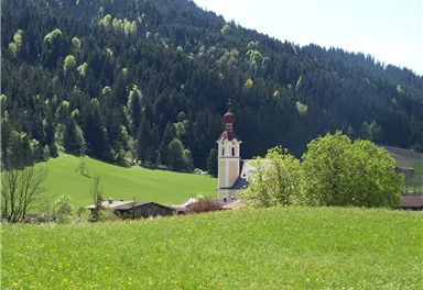
Starting from hiking starting point Going center (former tourist information Going) (764 m) follow the village road to the Raiffeisen Bank, turn left and go through the underpass. Now keep right and follow the Pramaweg following the signs to Badesee (bathing lake Going), past well-tended meadows and a small chapel. The Prama chapel is a real miner’s chapel and is a reminder of the times of former mining in Going.
When you arrive at...
Best Season
Jan
Feb
Mar
Apr
May
Jun
Jul
Aug
Sep
Oct
Nov
Dec
Skill Level
Endurance
Family-friendly
Stroller-friendly
Loop tour
More information at: www.wilderkaiser.info
Heading from St. Johann on the B178 road, take the first exit to Going and drive through the town until you see the Tourist Information Office and the hiking starting point on the left-hand side after crossing the bridge.


Current Weather
Today
2026-05-20
Morning
7 °C
Afternoon
8 °C
Evening
7 °C
Tomorrow
2026-05-21
Morning
6 °C
Afternoon
9 °C
Evening
9 °C
Friday
2026-05-22
Morning
9 °C
Afternoon
13 °C
Evening
12 °C
Saturday
2026-05-23
Morning
12 °C
Afternoon
15 °C
Evening
14 °C
Sunday
2026-05-24
Morning
13 °C
Afternoon
16 °C
Evening
14 °C
Monday
2026-05-25
Morning
13 °C
Afternoon
16 °C
Evening
15 °C
Tuesday
2026-05-26
Morning
14 °C
Afternoon
17 °C
Evening
15 °C
Wednesday
2026-05-27
Morning
15 °C
Afternoon
18 °C
Evening
16 °C
Thursday
2026-05-28
Morning
15 °C
Afternoon
18 °C
Evening
16 °C
Friday
2026-05-29
Morning
14 °C
Afternoon
17 °C
Evening
13 °C
Saturday
2026-05-30
Morning
12 °C
Afternoon
13 °C
Evening
11 °C
Sunday
2026-05-31
Morning
10 °C
Afternoon
12 °C
Evening
11 °C
Monday
2026-06-01
Morning
10 °C
Afternoon
12 °C
Evening
10 °C
Tuesday
2026-06-02
Morning
11 °C
Afternoon
13 °C
Evening
11 °C
Last updated at 05/20/2026, 02:00 AM
Contact
Contact
You have questions? We are happy to assist you.


