


 Deutsch
 Nederlands
Moon toboggan run

Exciting adventure stations for family tobogganing on the Hohe Salve.
Cable car valley station, Söll (725 m)
Cable car valley station, Söll (725 m)
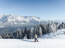
Tobogganing
Easy
4,0 km
We are sorry, your requested page is not available. You can start a new search on this page!
Exciting adventure stations for family tobogganing on the Hohe Salve.
Cable car valley station, Söll (725 m)
Cable car valley station, Söll (725 m)
Tobogganing
Easy
4,0 km

Picture-postcard panoramic scenery to Hintersteiner See lake, a natural gem.
Villag Center, Söll (689 m)
Hintersteiner See Lake, Scheffau (889 m)
Cycling
Intermediate
9,4 km
430 Elevation gain

Historical route pleasant to walk for everyone.
Hiking starting point Tourist Info, Söll (689 m)
Hiking starting point Tourist Info, Söll (689 m)
Hiking
Easy
1:00 h
3,0 km
40 Elevation gain

Access time0,16666666666666666
Via ferrata
Difficulty levelB-C
Via ferrara length100,0 m

A varied circular cycling route around hohe Salve mountain with plenty of refreshment stops.
anywhere along the tour
anywhere along the tour
Cycling
Intermediate
62,0 km
650 Elevation gain

Stripsenjochhaus – Stripsenkopf – Feldberg – Scheibenbichlalmen – Griesenau – Gasteig
Stripsenjochhaus, St. Johann in Tirol (1,577 m)
Gasteig (750 m)
Hiking
Intermediate
6:30 h
16,1 km
640 Elevation gain

From the Bergdoktorhaus to the Rübezahl-Alm mountain hut and the Carved Figures path to Ellmi’s Zauberwelt.
Hiking starting point Tourist Info, Ellmau (800 m)
Hiking starting point Tourist Info, Ellmau (800 m)
Hiking
Easy
5:30 h
15,8 km
730 Elevation gain

Ancient path of the romans - a better stroll.
Hiking starting point Tourist Info, Söll (689 m)
Hiking starting point Tourist Info, Söll (689 m)
Hiking
Easy
1:00 h
3,0 km
55 Elevation gain
Mountain tour to the extreme climbers’ training rock and spectacle of nature with refreshment stop at the Graspoint-Niederalm.
Hiking starting point Hüttling, Going (820 m)
Hiking starting point Hüttling, Going (820 m)
Hiking
Intermediate
3:00 h
5,5 km
520 Elevation gain

Number of rope lengths14
Access time2,0
Alpine climbing route
Multi-rope length difficulty levels6+/A0

Comfortable round with a magnificent view of the Hohe Salve.
Mountain station gondola Hexenwasser, Söll (1,150 m)
Mountain station gondola Hexenwasser, Söll (1,150 m)
Hiking
Easy
0:35 h
1,8 km
50 Elevation gain

Culinary tour on the Hohe Salve
Bergstation Rabennest (1.150 m)
Bergstation Rabennest (1.150 m)
Hiking
Easy
1:30 h
4,0 km
160 Elevation gain

"Enjoyable" winter hike with a cozy stop and a fantastic panorama.
Hiking starting point Tourist Info, Ellmau (800 m)
Hiking starting point Tourist Info, Ellmau (800 m)
Hiking
Easy
4:30 h
10,5 km
370 Elevation gain

Family hike on Austria’s longest sculpture trail
Hartkaiser summit station, Ellmau (1,555 m)
Rübezahl-Alm, Ellmau (1,174 m)
Hiking
Intermediate
1:00 h
2,5 km
50 Elevation gain

From the flowery village to the water jewel of the Alps.
Hiking starting point Franzlhof, Söll (703 m)
Seestüberl restaurant, Hintersteiner See, Scheffau (890 m)
Hiking
Intermediate
3:15 h
9,5 km
460 Elevation gain

Pleasant hike through forests and across meadows to the sunny plateau of Going and back
Hiking starting point Going center (former tourist information Going) (764 m)
Hiking starting point Going center (former tourist information Going) (764 m)
Hiking
Easy
1:15 h
4,1 km
70 Elevation gain

Varied beginner trail round between the Kaiser towns of Ellmau and Going.
Wanderstartplatz Tourismus Info, Ellmau
Wanderstartplatz Tourismus Info, Ellmau
Jogging
Easy
10,2 km
520 Elevation gain

Going church square - Bergdoktor practice Ellmau and Gruberhof Söll. This e-bike tour gives you a chance to enjoy the magnificent mountain panorama at the foot of the Wilder Kaiser and takes you past the three main filming locations of the “Der Bergdoktor” (The Mountain Doctor) TV series.
Going church square
Going church square
Cycling
Intermediate
51,0 km
990 Elevation gain

Winter hike with picturesque views of the Wilder Kaiser to the 'Wolfsegg' plateau
Hiking starting point Going center (former tourist information Going) (764 m)
Hiking starting point Going center (former tourist information Going) (764 m)
Hiking
Easy
1:30 h
4,0 km
65 Elevation gain

More than 190 sport climbing routes, difficulty levels 3 to 9a+
Route number191
Access time0,6666666666666666
Sport climbing

Nice circular hike through Going with visits to numerous chapels.
Hiking starting point Going center (former tourist information Going) (764 m)
Hiking starting point Going center (former tourist information Going) (764 m)
Hiking
Easy
2:45 h
9,3 km
210 Elevation gain

Atmospheric forest walk along the snow-white creek.
Hiking starting point Tourist Info, Scheffau (738 m)
Hiking starting point Tourist Info, Scheffau (738 m)
Hiking
Intermediate
2:00 h
4,2 km
160 Elevation gain

A moderately challenging panoramic circuit around the Astberg mountain.
Tourist Info, Going (764 m)
Tourist Info, Going (764 m)
Cycling
Intermediate
15,3 km
480 Elevation gain
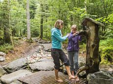
Refreshing walk through the Kneipp facilities and adventures in the Rehbachklamm gorge
Hiking starting point Tourist Info, Scheffau (738 m)
Hiking starting point Tourist Info, Scheffau (738 m)
Hiking
Intermediate
2:00 h
7,1 km
330 Elevation gain

Easier and more level circular walk through the sunny district of Prama for walkers or families with pushchairs.
Hiking starting point Going center (former tourist information Going) (764 m)
Hiking starting point Going center (former tourist information Going) (764 m)
Hiking
Easy
1:00 h
3,9 km
60 Elevation gain

Number of rope lengths6
Access time2,0
Alpine climbing route
Multi-rope length difficulty levels6+

Crystal-clear mountain lake and magnificent views of the Wilder Kaiser’s western summits
Hintersteiner See, Scheffau (890 m)
Hintersteiner See, Scheffau (890 m)
Hiking
Easy
1:30 h
5,2 km
130 Elevation gain

A short winter walk on Hartkaiser hrough Ellmi's magical world.
Hiking starting point Tourist Info, Ellmau (800 m)
Hiking starting point Tourist Info, Ellmau (800 m)
Hiking
Easy
0:30 h
1,0 km
25 Elevation gain

circuit tour with breathtaking panorama
Astberg Bergstation
Astberg Bergstation
Hiking
Easy
1:20 h
4,1 km
140 Elevation gain

Round tour through Scheffau with vitalising stations for refreshment and relaxation.
Hiking starting point Tourist Info, Scheffau (738 m)
Hiking starting point Tourist Info, Scheffau (738 m)
Hiking
Easy
1:15 h
4,3 km
90 Elevation gain
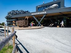
Hike to the Hexenwasser and get rewarded with a view.
Bergbahn valley station, Söll (724 m)
Bergbahn valley station, Söll (724 m)
Hiking
Easy
3:00 h
7,9 km
410 Elevation gain
Gasteig – Wilder-Kaiser-Steig – Ursulablick – Gscheuerkopf – Graspoint-Hochalm – Graspoint-Niederalm – Going, Hüttling
Gasteig (750 m)
Hiking starting point Hüttling, Going (820 m)
Hiking
Intermediate
5:15 h
10,8 km
840 Elevation gain

Hiking trail no. 8 to the Hausberg via the Marienkapelle (St Mary’s Chapel)
Hiking starting point Tourist Information Office, Ellmau (798 m)
Brenner Alm, Ellmau (1,236 m)
Hiking
Easy
1:30 h
3,5 km
500 Elevation gain
Mittelschwierige Aufstiegsroute entlang der Piste Nr. 80 auf den Hartkaiser.
Hartkaiserbahn Talstation,
Hartkaiserbahn Bergstation, Ellmau (1.520 m)
Ski tour
Intermediate
2:00 h
3,5 km
700 Elevation gain

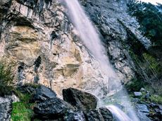
Moderate tour to the Schleier Waterfall, a great outdoor experience.
Tourist Info, Going (764 m)
Tourist Info, Going (764 m)
Cycling
Intermediate
6,6 km
410 Elevation gain
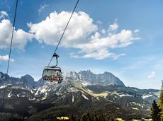
The highlight for everyone who loves hiking for pleasure - lush Alpine meadows, sparkling mountain lakes and delightful food in the Kitzbühel Alps. And the Bergbahnen Wilder Kaiser - Brixental summer cable cars make the ascent and descent easy.
Astberg, Going
Hochsöll
Hiking
Easy
6:45 h
20,0 km
720 Elevation gain

Family roundtrip through the Rebachklamm to the Seilabodenkreuz, via the Kaiseralm and the Jägerwirt back to the center of Scheffau.
Community Hall, Scheffau (740 m)
Community Hall, Scheffau (740 m)
Hiking
Intermediate
3:15 h
9,7 km
510 Elevation gain

The largest bouldering hall in the Tirolean Unterland region.
Climbing room
Family-friendly, leisurely circular hike around the Astberg mountain
Astberg mountain station, Going (1.251 m)
Astberg mountain station, Going (1.251 m)
Hiking
Easy
0:30 h
1,5 km
80 Elevation gain

A hike on varied paths around the Achleitberg.
Hiking starting point Tourist Info, Scheffau (738 m)
Hiking starting point Tourist Info, Scheffau (738 m)
Hiking
Intermediate
5:45 h
18,0 km
540 Elevation gain