

Winter walking
Wolfsegg winter circuit
Closed
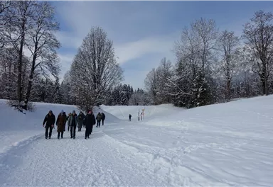
Winter hike with picturesque views of the Wilder Kaiser to the 'Wolfsegg' plateau
4,00 km
65 m
01:30 h


Route
4,00 km
65 m
01:30 h
838 m
Starting Point
Hiking starting point Going center (former tourist information Going) (764 m)
End Point
Hiking starting point Going center (former tourist information Going) (764 m)
What to do in an emergency? Call emergency number
140 - Mountain Rescue (Bergrettung)
112 - European Emergency Number
133 - Police
144 - Ambulance
Many routes have rescue points at the hiking signs, which can be used as a clear location identification in an emergency.
The Alpine Club provides tips for optimal preparation for mountain hiking.
SOS-EU-Alp App
The SOS EU ALP app allows you to determine your location (x,y coordinates) via your smartphone. In an emergency, this location data can be sent directly to the responsible control center (Tyrol, South Tyrol or Bavaria).
Important Information
Description
At this underpass, keep left of the creek and hike northwards with the Wilder Kaiser in view. Pass the farm ‘Unterhausbach’ until you come to a specially prepared winter hiking trail on the right.
Following this trail, you cross the Hausbach creek and follow a beautiful valley with a deep winter atmosphere to the ‘Wolfsegg’ plateau. Once on the plateau, captivated by the wonderful view of the Wilder Kaiser, you hike along the prepared path until you come...
Best Season
Jan
Feb
Mar
Apr
May
Jun
Jul
Aug
Sep
Oct
Nov
Dec
Skill Level
Endurance
Loop tour
More information at: www.wilderkaiser.info/mobility


Current Weather
Wednesday
2026-05-20
Morning
7 °C
Afternoon
8 °C
Evening
7 °C
Today
2026-05-21
Morning
6 °C
Afternoon
10 °C
Evening
9 °C
Tomorrow
2026-05-22
Morning
10 °C
Afternoon
13 °C
Evening
12 °C
Saturday
2026-05-23
Morning
12 °C
Afternoon
15 °C
Evening
14 °C
Sunday
2026-05-24
Morning
13 °C
Afternoon
16 °C
Evening
14 °C
Monday
2026-05-25
Morning
14 °C
Afternoon
18 °C
Evening
15 °C
Tuesday
2026-05-26
Morning
15 °C
Afternoon
17 °C
Evening
15 °C
Wednesday
2026-05-27
Morning
14 °C
Afternoon
17 °C
Evening
14 °C
Thursday
2026-05-28
Morning
13 °C
Afternoon
16 °C
Evening
14 °C
Friday
2026-05-29
Morning
12 °C
Afternoon
15 °C
Evening
13 °C
Saturday
2026-05-30
Morning
12 °C
Afternoon
16 °C
Evening
14 °C
Sunday
2026-05-31
Morning
12 °C
Afternoon
15 °C
Evening
12 °C
Monday
2026-06-01
Morning
12 °C
Afternoon
14 °C
Evening
12 °C
Tuesday
2026-06-02
Morning
11 °C
Afternoon
11 °C
Evening
10 °C
Last updated at 05/20/2026, 02:00 PM
Contact
Contact
You have questions? We are happy to assist you.


