

Hiking tour
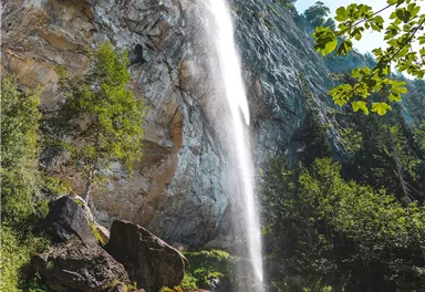
Schleier Waterfall circular hiking route
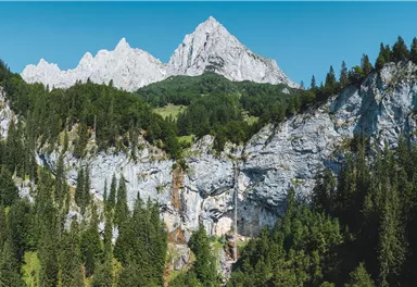
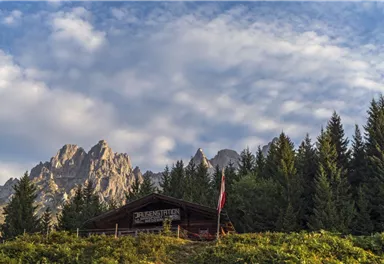
Mountain tour to the extreme climbers’ training rock and spectacle of nature with refreshment stop at the Graspoint-Niederalm.
Medium
5,50 km
520 m
03:00 h

Medium
Route
5,50 km
520 m
03:00 h
1283 m
Starting Point
Hiking starting point Hüttling, Going (820 m)
End Point
Hiking starting point Hüttling, Going (820 m)
What to do in an emergency? Call emergency number
140 - Mountain Rescue (Bergrettung)
112 - European Emergency Number
133 - Police
144 - Ambulance
Many routes have rescue points at the hiking signs, which can be used as a clear location identification in an emergency.
The Alpine Club provides tips for optimal preparation for mountain hiking.
SOS-EU-Alp App
The SOS EU ALP app allows you to determine your location (x,y coordinates) via your smartphone. In an emergency, this location data can be sent directly to the responsible control center (Tyrol, South Tyrol or Bavaria).
Description
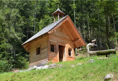
Give yourself some time here and have a look at the small chapel, also from inside, and fill your water bottle with fresh Kaiser water from the fountain next door.
The forest road now takes you towards the Wilder Kaiser. When you come to the “Fußweg-Wasserfall-Graspoint” intersection, the trail leads you across Alpine pastures and through the forest and, after about 20 minutes, you continue on the forest road.
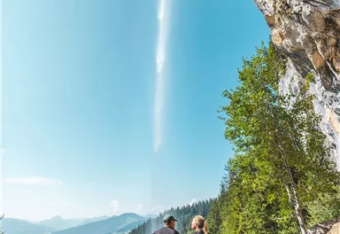
A narrow path, which requires a certain degree of surefootedness, now brings you to the Schleier Waterfall, a paradise for climbers. Here at this power...
Best Season
Jan
Feb
Mar
Apr
May
Jun
Jul
Aug
Sep
Oct
Nov
Dec
Skill Level
Endurance
Family-friendly
Loop tour
More information at: www.wilderkaiser.info/mobility
Heading from Wörgl or Kufstein on the B178 road, take the Going Prama exit before you reach the Stanglwirt hotel. When you reach the first junction, turn right in the direction of the bathing lake. Keep following the road towards the Kaisergebirge mountain range until you reach the next junction, which is located between two farmhouses. Turn left here and follow the road until you reach the hiking starting point and the car park.
It is a day car park, which means that no ticket can be purchased for several days. The parking ticket is therefore only valid on the day of issue! It is a public car park from May to October. During the winter months from November to April the car park is not attended. During this time the use is at your own risk! Camping and permanent parking is prohibited on this car park. (Vehicles that are parked illegally will be reported to the police and towed.)


Current Weather
Tuesday
2026-05-12
Morning
1 °C
Afternoon
-2 °C
Evening
-1 °C
Today
2026-05-13
Morning
Afternoon
5 °C
Evening
4 °C
Tomorrow
2026-05-14
Morning
1 °C
Afternoon
2 °C
Evening
Friday
2026-05-15
Morning
1 °C
Afternoon
4 °C
Evening
2 °C
Saturday
2026-05-16
Morning
1 °C
Afternoon
2 °C
Evening
1 °C
Sunday
2026-05-17
Morning
Afternoon
2 °C
Evening
3 °C
Monday
2026-05-18
Morning
3 °C
Afternoon
5 °C
Evening
4 °C
Tuesday
2026-05-19
Morning
4 °C
Afternoon
6 °C
Evening
6 °C
Wednesday
2026-05-20
Morning
6 °C
Afternoon
9 °C
Evening
7 °C
Thursday
2026-05-21
Morning
7 °C
Afternoon
10 °C
Evening
8 °C
Friday
2026-05-22
Morning
8 °C
Afternoon
10 °C
Evening
8 °C
Saturday
2026-05-23
Morning
8 °C
Afternoon
10 °C
Evening
9 °C
Sunday
2026-05-24
Morning
8 °C
Afternoon
11 °C
Evening
10 °C
Monday
2026-05-25
Morning
8 °C
Afternoon
12 °C
Evening
10 °C
Last updated at 05/12/2026, 02:00 PM
Contact
Contact
You have questions? We are happy to assist you.


