


 Deutsch
 Nederlands
Hausberg trail (no. 8)

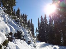
Hiking trail no. 8 to the Hausberg via the Marienkapelle (St Mary’s Chapel)
Hiking starting point Tourist Information Office, Ellmau (798 m)
Brenner Alm, Ellmau (1,236 m)
Hiking
Easy
1:30 h
3,5 km
500 Elevation gain
We are sorry, your requested page is not available. You can start a new search on this page!
Hiking trail no. 8 to the Hausberg via the Marienkapelle (St Mary’s Chapel)
Hiking starting point Tourist Information Office, Ellmau (798 m)
Brenner Alm, Ellmau (1,236 m)
Hiking
Easy
1:30 h
3,5 km
500 Elevation gain

Old path - now renovated and featuring a pleasant series of ascents and descents.
Hiking starting point Bergbahn, Söll (725 m)
Hiking starting point Bergbahn, Söll (725 m)
Hiking
Intermediate
4:30 h
13,5 km
470 Elevation gain

Stripsenjochhaus – Eggersteig – Steinerne Rinne – Ellmauer Tor – Jubiläumssteig – Gruttenhütte
Stripsenjochhaus, St. Johann in Tirol (1,577 m)
Gaudeamushütte, Going (1,263 m)
Hiking
Difficult
5:00 h
6,3 km
590 Elevation gain

Past inn, farm and chapel in the Kaiser countryside.
Hiking starting point Going Center (former Tourist informatin Going)
Hiking starting point Going Center (former Tourist informatin Going)
Cross-country skiing
Easy
1,2 km
10 Elevation gain

This familyfriendly hike leads you along the panoramic trail from the Brandstadl mountain in Scheffau to the Hartkaiser mountain in Ellmau.
Brandstadlbahn mountain station, Scheffau (1,650 m) or Hartkaiserbahn mountain station, Ellmau (1.550 m)
Brandstadlbahn mountain station, Scheffau (1,650 m) or Hartkaiserbahn mountain station, Ellmau (1.550 m)
Hiking
Easy
1:50 h
6,0 km
170 Elevation gain
Mittelschwierige Aufstiegsroute entlang der Piste Nr. 80 auf den Hartkaiser.
Hartkaiserbahn Talstation,
Hartkaiserbahn Bergstation, Ellmau (1.520 m)
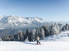
Ski tour
Intermediate
2:00 h
3,5 km
700 Elevation gain

Culinary tour on the Hohe Salve
Bergstation Rabennest (1.150 m)
Bergstation Rabennest (1.150 m)
Hiking
Easy
1:30 h
4,0 km
160 Elevation gain

A moderately challenging panoramic circuit around the Astberg mountain.
Tourist Info, Going (764 m)
Tourist Info, Going (764 m)
Cycling
Intermediate
15,3 km
480 Elevation gain

This easy family hike takes you via the Bergdoktorhaus to the Berggasthof Hochschwendt mountain inn.
Wanderstartplatz Tourist Info, Ellmau (800m)
Wanderstartplatz Tourist Info, Ellmau (800m)
Hiking
Easy
2:45 h
8,7 km
270 Elevation gain

Crystal-clear mountain lake and magnificent views of the Wilder Kaiser’s western summits
Hintersteiner See, Scheffau (890 m)
Hintersteiner See, Scheffau (890 m)
Hiking
Easy
1:30 h
5,2 km
130 Elevation gain

Explore the sunny foot of the Pölven mountain.
Cross-country skiing
Easy
0,9 km

Along with the Murmeltierfelsen and Gamsfelsen, there are a total of 17 climbing routes of difficulty levels 3 to 6b+ near the Gaudeamushütte mountain hut.
Route number19
Access time1,0
Sport climbing
Hike to the Hexenwasser and get rewarded with a view.
Bergbahn valley station, Söll (724 m)
Bergbahn valley station, Söll (724 m)
Hiking
Easy
3:00 h
7,9 km
410 Elevation gain
This short and easy valley circuit takes you around the village of Going am Wilden Kaiser and past the bathing lake, a delightful spot to cool off in fine weather.
Hiking starting point Going center (former tourist information Going) (764 m)
Hiking starting point Going center (former tourist information Going) (764 m)
Hiking
Easy
1:00 h
6,4 km
110 Elevation gain

Hike via four mountain huts Rübezahl-Alm, Jägerhütte and Hochschwendt.
Hiking starting point Tourist Info, Ellmau (800 m)
Hiking starting point Tourist Info, Ellmau (800 m)
Hiking
Easy
6:15 h
14,0 km
600 Elevation gain
Gruttenhütte - Kaiser-Hochalm - Steiner-Hochalm - Jägersteig - Walleralm - Hochegg - Kaindlhütte
Gruttenhütte, Ellmau (1,620 m)
Hintersteiner See, Scheffau (889 m)
Hiking
Intermediate
5:30 h
13,5 km
560 Elevation gain

Comfortable round with a magnificent view of the Hohe Salve.
Mountain station gondola Hexenwasser, Söll (1,150 m)
Mountain station gondola Hexenwasser, Söll (1,150 m)
Hiking
Easy
0:35 h
1,8 km
50 Elevation gain

Onto the Hausberg mountain with panoramic views of the Wilder Kaiser and Hartkaiser mountains and back via the Ranhartalm.
Hiking starting point Tourist Info, Ellmau (800 m)
Hiking starting point Tourist Info, Ellmau (800 m)
Hiking
Easy
8:00 h
22,8 km
1020 Elevation gain

Leisurely path of reflection to the St. Anna chapel at Lengau
Parkplatz Liftstation Itter (655 m)
Lengauer Kapelle
Hiking
Easy
1:15 h
3,2 km
270 Elevation gain

Pleasant circular hiking trail through forests and meadows to the romantically situated moor lake.
Hiking starting point Franzlhof, Söll (703 m)
Hiking starting point Franzlhof, Söll (703 m)
Hiking
Intermediate
2:00 h
5,7 km
240 Elevation gain

Moderately difficult ascent route along the ski route 80c/d to the Hartkaiser.
Hartkaiserbahn valley station, Ellmau (824 m)
Hartkaiserbahn mountain station, Ellmau (1.524 m)
Ski tour
Intermediate
2:30 h
4,2 km
700 Elevation gain
Romantic forest walk in tranquil surroundings.
Hiking starting point Tourist Info, Ellmau (800 m)
Hiking starting point Tourist Info, Ellmau (800 m)
Hiking
Easy
5:30 h
12,7 km
470 Elevation gain

Fork 823/826 – via waterfall – Veitskirche – Steiner-Hochalm
Fork on the Wilder-Kaiser-Steig 823/826 (1,405 m)
Steiner-Hochalm, Scheffau (1,257 m)
Hiking
Intermediate
2:30 h
3,8 km
360 Elevation gain
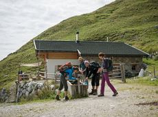
Sturdy boots will help keep your ankles and feet happy on this hike, full of the best things Tirol has to offer: well-maintained trails, wildflowers galore and waterfalls beckon the adventurous hiker ready for a strenuous climb with breathtaking views of lofty Wilder Kaiser Mountain Range as your reward. The nature reserve’s landscape will win you over with its diverse beauty. The pasture regions are covered with soft grassy meadows, and hikers are greeted by lofty Wilder Kaiser Mountain Range with rugged Maukspitze, Ackerlspitze, Regalpspitze and Törlspitze Peaks, all “Two-Thousanders” that average 2,000 metres altitude. Trailhead is Rummlerhof Inn, northwest of the village centre of St. Johann. After a successful first segment, why not take a rest at Gaudeamus Hut, raise your glass and sing: “Gaudeamus igitur – Let us be happy!” For many hikers this is far enough, contentment has already set in. Adventurous souls continue on the trail that works its way up across Klamml Gorge to Grutten Hut, which entails another 400 metres of climbing.
Rummlerhof, St.Johann in Tirol
Gaudeamushütte
Hiking
Intermediate
5:00 h
13,0 km
1060 Elevation gain

Short hike from Jägerwirt to the Kaiseralm with great mountain views.
Hiking starting point Jägerwirt, Scheffau (883 m)
Hiking starting point Jägerwirt, Scheffau (883 m)
Hiking
Easy
1:45 h
5,0 km
250 Elevation gain

Access time0,16666666666666666
Via ferrata
Difficulty levelD
Via ferrara length250,0 m
A mountain with lots of tobogganing options and good refreshment stops.
Astbergbahn Talstation, Going (805 m)
Astbergbahn Talstation, Going (805 m)
Tobogganing
Intermediate
3,2 km

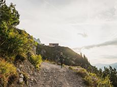
Experience impressive low and panoramic views in the unique rocky scenery of the legendary "Wild Castle", as this area is known according to legend thanks to its many turrets, peaks, hollows and balconies.
Wochenbrunner Alm, Ellmau (1.085 m)
Wochenbrunner Alm, Ellmau (1.085 m)
Hiking
Difficult
3:45 h
6,3 km
630 Elevation gain

Explore the popular path past the TV backdrop on snowshoes.
Cable car valley station, Söll (725 m)
Cable car valley station, Söll (725 m)
Hiking
Easy
4:45 h
7,0 km
350 Elevation gain

Snowshoe hike via the Kaiseralmen with starting and finishing at the Gasthof Jägerwirt.
Gasthof Jägerwirt, Scheffau (883 m)
Gasthof Jägerwirt, Scheffau (883 m)
Hiking
Intermediate
3:15 h
4,8 km
250 Elevation gain

Easy snowshoe hike at the foot of the Wilder Kaiser.
Postbus stop Dorf/Bauhof, Ellmau
Postbus stop Dorf/Bauhof, Ellmau
Hiking
Easy
0:40 h
1,3 km
10 Elevation gain
A beautiful easy hike at the foot of the Wilder Kaiser
Hiking starting point Tourist Info, Ellmau (800 m)
Hiking starting point Tourist Info, Ellmau (800 m)
Hiking
Easy
1:45 h
5,9 km
60 Elevation gain

Pleasant high-altitude walk taking in the mountain and Astbergsee lake - the mirror of the Wilder Kaiser!
Blattlalm, Going (1,246 m)
Blattlalm, Going (1,246 m)
Hiking
Easy
0:40 h
1,7 km
80 Elevation gain

A classic amongst the via ferratas on the Wilder Kaiser massif – ideal as a 2-day tour.
Access time3,5
Via ferrata
Difficulty levelD
Via ferrara length675,0 m

Savour the wonder of the winter landscape – experience the winter magic for yourself by crunching through the pristine snow with your snowshoes. Enjoy unique impressions and experiences as you explore the white winter splendour and take in the spectacular view over the surrounding mountain scenery.
Church square, Going (769 m)
Church square, Going (769 m)
Hiking
Easy
1:30 h
2,9 km
110 Elevation gain
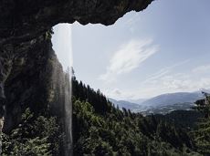
Going, Hüttling - Schleierwasserfall - Obere Regalm - Baumgartenköpfl (Bergsteigergrab) - Gaudeamushütte
Hiking starting point Hüttling, Going (820 m)
Gaudeamushütte, Going (1,263 m)
Hiking
Intermediate
4:00 h
7,3 km
860 Elevation gain

Bike to the Hexenwasser theme park and Hochsöll.
Village Center, Söll (689 m)
Hexenwasser theme park, Hochsöll (1,150 m)
Cycling
Intermediate
5,1 km
480 Elevation gain

Bike tour of medium difficulty between Hexenwasser theme park and Filzalmsee.
Tourist Information Office, Söll (703 m)
Filzalmsee
Cycling
Intermediate
8,8 km
680 Elevation gain

By bike through the culinary region Wilder Kaiser.
anywhere along the tour
anywhere along the tour
Cycling
Intermediate
38,3 km
560 Elevation gain

A short winter walk on Hartkaiser hrough Ellmi's magical world.
Hiking starting point Tourist Info, Ellmau (800 m)
Hiking starting point Tourist Info, Ellmau (800 m)
Hiking
Easy
0:30 h
1,0 km
25 Elevation gain