

Via ferrata
Weisse Gams (Weißbach)
Open
250,00 m
Route
250,00 m
What to do in an emergency? Call emergency number
140 - Mountain Rescue (Bergrettung)
112 - European Emergency Number
133 - Police
144 - Ambulance
Many routes have rescue points at the hiking signs, which can be used as a clear location identification in an emergency.
The Alpine Club provides tips for optimal preparation for mountain hiking.
SOS-EU-Alp App
The SOS EU ALP app allows you to determine your location (x,y coordinates) via your smartphone. In an emergency, this location data can be sent directly to the responsible control center (Tyrol, South Tyrol or Bavaria).
Description
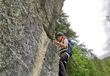
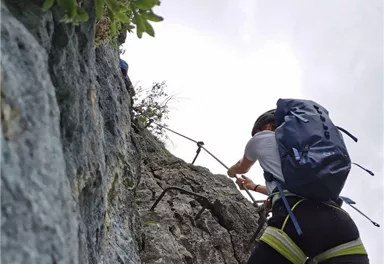
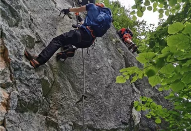
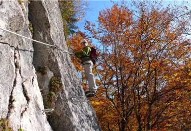
Interesting via ferrata with the starting point near the village centre of Weißbach directly in the valley. Steep passages, traverses, beautiful slabs through steep, forested rocks.
Partly a bit grassy respectively earthy!
Best Season
Jan
Feb
Mar
Apr
May
Jun
Jul
Aug
Sep
Oct
Nov
Dec
Climbing time (guideline)
0,75
Exposure SW
Altitude difference via ferrata
130
Walk time to entry point (guideline)
0,16666666666666666
Walking time descent (guideline)
0,25
Current Weather
Today
2026-06-02
Morning
13 °C
Afternoon
16 °C
Evening
12 °C
Tomorrow
2026-06-03
Morning
5 °C
Afternoon
7 °C
Evening
8 °C
Thursday
2026-06-04
Morning
11 °C
Afternoon
15 °C
Evening
10 °C
Friday
2026-06-05
Morning
4 °C
Afternoon
6 °C
Evening
7 °C
Saturday
2026-06-06
Morning
10 °C
Afternoon
13 °C
Evening
11 °C
Sunday
2026-06-07
Morning
10 °C
Afternoon
13 °C
Evening
11 °C
Monday
2026-06-08
Morning
11 °C
Afternoon
13 °C
Evening
12 °C
Tuesday
2026-06-09
Morning
11 °C
Afternoon
14 °C
Evening
12 °C
Wednesday
2026-06-10
Morning
11 °C
Afternoon
14 °C
Evening
12 °C
Thursday
2026-06-11
Morning
11 °C
Afternoon
14 °C
Evening
12 °C
Friday
2026-06-12
Morning
13 °C
Afternoon
15 °C
Evening
13 °C
Saturday
2026-06-13
Morning
12 °C
Afternoon
14 °C
Evening
12 °C
Sunday
2026-06-14
Morning
12 °C
Afternoon
12 °C
Evening
11 °C
Monday
2026-06-15
Morning
11 °C
Afternoon
13 °C
Evening
11 °C
Last updated at 06/02/2026, 02:00 PM
Contact
Contact
You have questions? We are happy to assist you.


