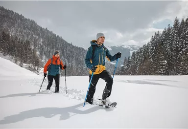
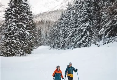
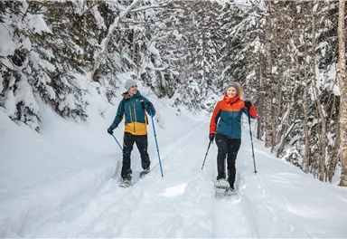
Zahme Gams (Weißbach)
Access time0,16666666666666666
Via ferrata
Difficulty levelB-C
Via ferrara length100,0 m
We are sorry, your requested page is not available. You can start a new search on this page!
Access time0,16666666666666666
Via ferrata
Difficulty levelB-C
Via ferrara length100,0 m
Enjoy unspoilt views of the Sölllandl region from snow-covered fields.
Hiking starting point Franzlhof, Söll (703 m)
Hiking
2:15 h
5,8 km
100 Elevation gain
Across snow-covered meadows along the Going 'sunny side' (Sonnseite).
Bathing lake, Going (742 m)
Hiking
Easy
1:30 h
3,9 km
60 Elevation gain
Gasteig – Wilder-Kaiser-Steig – Ursulablick – Gscheuerkopf – Graspoint-Hochalm – Graspoint-Niederalm – Going, Hüttling
Gasteig (750 m)
Hiking starting point Hüttling, Going (820 m)
Hiking
Intermediate
5:15 h
10,8 km
840 Elevation gain
Mountain tour to the extreme climbers’ training rock and spectacle of nature with refreshment stop at the Graspoint-Niederalm.
Hiking starting point Hüttling, Going (820 m)
Hiking
Intermediate
3:30 h
5,5 km
520 Elevation gain
Head through well-shaded forests of green to reach the Ellmau Stone Circle. This is a place with a special energy, making it an inviting option for taking some time to relax.
Hiking starting point Wochenbrunner Alm, Ellmau (1,085 m)
Hiking
Intermediate
1:00 h
2,4 km
120 Elevation gain
Exciting round trip for adults and children through the Rehbach gorge.
Hiking starting point Tourist Info, Scheffau (738 m)
Hiking
Intermediate
2:00 h
5,5 km
280 Elevation gain
A classic amongst the via ferratas on the Wilder Kaiser massif – ideal as a 2-day tour.
Access time3,5
Via ferrata
Difficulty levelD
Via ferrara length675,0 m
Along with the Murmeltierfelsen and Gamsfelsen, there are a total of 17 climbing routes of difficulty levels 3 to 6b+ near the Gaudeamushütte mountain hut.
Route number19
Access time1,0
Sport climbing
Two very demanding, fantastic lookout peaks on the Wilder Kaiser, which are not to be underestimated.
Hiking starting point Wegscheid, Scheffau (883 m)
Hiking
Difficult
9:00 h
11,0 km
1440 Elevation gain
Short, crisp connection between the Blattlloipe and the Schwendterloipe.
Cross-country skiing
Intermediate
0,5 km
30 Elevation gain
A running circuit from Scheffau towards Ellmau via the Auwald district.
Starting point Scheffau Tourist Information Office (752 m)
Jogging
Easy
7,7 km
180 Elevation gain
Number of rope lengths12
Access time2,0
Alpine climbing route
Multi-rope length difficulty levels6+ (6-/A0)
The panoramic Scheffauer is the last high peak in the west at 2,111 m above sea level.
Hiking starting point Bärnstatt, Scheffau (920 m)
Hiking
Difficult
7:00 h
7,9 km
1180 Elevation gain
A short MTB tour to the Walleralm mountain inn, easily combined with other routes.
Parkplatz Pension Maier, Scheffau (925 m)
Parkplatz Walleralm, Söll (685 m)
Cycling
Intermediate
3,3 km
260 Elevation gain
31 routes, including 14 multi-pitch.
Route number32
Access time1,5
Sport climbing
Hikers, young and old alike, will find in this wild romantic gorge natural playgrounds such as bridges and balancing beams by streams and ponds.
Hiking starting point Tourist Info, Scheffau (738 m)
Hiking
Easy
1:15 h
3,5 km
130 Elevation gain
Varied hike with cosy refreshment stops and a wonderful mountain panorama.
mountain station Salvistabahn / Kleine Salve
Middle station Salvistabahn Itter
Hiking
Intermediate
2:45 h
7,4 km
360 Elevation gain
The highlight for everyone who loves hiking for pleasure - lush Alpine meadows, sparkling mountain lakes and delightful food in the Kitzbühel Alps. And the Bergbahnen Wilder Kaiser - Brixental summer cable cars make the ascent and descent easy.
Astberg, Going
Hochsöll
Hiking
Easy
6:45 h
20,0 km
720 Elevation gain
A beautiful easy hike at the foot of the Wilder Kaiser
Hiking starting point Tourist Info, Ellmau (800 m)
Hiking
Easy
1:45 h
5,9 km
60 Elevation gain
Access time2,0
Via ferrata
Difficulty levelB-C
Via ferrara length200,0 m
Demanding mountain tour to the Kleines Törl pass, the little "brother" of the Ellmauer Tor in the Ostkaiser.
Hiking starting point Tannbichl, Going (855 m)
Hiking
Difficult
8:00 h
12,0 km
1260 Elevation gain
A run during which you can enjoy peace and quiet in the great outdoors.
Starting point Scheffau Tourist Information Office (752 m)
Jogging
Intermediate
6,1 km
260 Elevation gain
Picturesque circular hiking trail on the sunny side of Going in unspoilt nature - over snow fields with fantastic views of Going aht the Wilder Kaiser.
Hiking starting point Going center (former tourist information Going) (764 m)
Hiking
Easy
1:45 h
4,8 km
80 Elevation gain
Crystal-clear mountain lake and magnificent views of the Wilder Kaiser’s western summits
Hintersteiner See, Scheffau (890 m)
Hiking
Easy
1:30 h
5,2 km
130 Elevation gain
A crisp, varied tour from Söll via the Lengau to Bad Häring and over the Werlberg, past the Juffinger Jöchl back to Söll. Between the individual forest sections, you are rewarded again and again with magnificent views of large parts of the Inntal valley.
Village centre, Söll (689 m)
Cycling
Difficult
24,0 km
900 Elevation gain
Romantic forest walk in tranquil surroundings.
Hiking starting point Tourist Info, Ellmau (800 m)
Hiking
5:30 h
12,7 km
470 Elevation gain
Number of rope lengths8
Access time2,0
Alpine climbing route
Multi-rope length difficulty levels8-
Kufstein – Brentenjoch – Kaindlhütte
Kaiserlift summit station, Kufstein (1,255 m)
Kaindlhütte, Scheffau (1,293 m)
Hiking
Easy
1:30 h
2,9 km
220 Elevation gain
Varied round tour with many refreshments and wonderful views
Tourist Information Office, Scheffau (737 m)
Cycling
Intermediate
23,6 km
660 Elevation gain
Experience culinaric highlights for the whole family.
Bergstation Rabennest (1.150 m)
Hiking
Easy
0:40 h
1,7 km
90 Elevation gain
This stage takes hikers to the small town of Kufstein located on the banks of the Inn river – a town which has been celebrated in song and is steeped in history and character. Walkers make their way through the lush and verdant beauty of a pasture paradise with cosy huts and mountain restaurants before stopping for a rest at the Brentenjochhütte hut (delicious “Kiachl” are served every Saturday). With so many sights to marvel at, don't forget to keep an eye out for the nearly one thousand species of flowering plants native to the Kaiser Mountains.
Hintersteiner See
Kufstein
Hiking
Intermediate
4:00 h
12,5 km
160 Elevation gain
Past inn, farm and chapel in the Kaiser countryside.
Hiking starting point Going Center (former Tourist informatin Going)
Cross-country skiing
Easy
1,2 km
10 Elevation gain
Hike from the Kaiserlift mountain station via the Kaindlhütte and Walleralm to Hintersteiner See.
Mountain station Kaiserlift, Kufstein (1256 m)
Hiking starting point Seestüberl, Scheffau (890 m)
Hiking
Intermediate
3:20 h
8,8 km
340 Elevation gain
Easy snowshoe hike at the foot of the Wilder Kaiser.
Postbus stop Dorf/Bauhof, Ellmau
Hiking
0:40 h
1,3 km
10 Elevation gain
Beautiful circular walk around the frozen Lake Hinterstein.
Hiking starting point Seestüberl, Scheffau (890 m)
Hiking
2:00 h
5,7 km
70 Elevation gain
Baumgartenköpfl (Bergsteigergrab) – Wilder-Kaiser-Steig – Jubiläumssteig – Gruttenhütte
Brennender Palven (1,572 m)
Gruttenhütte, Ellmau (1,620 m)
Hiking
Difficult
2:30 h
3,3 km
410 Elevation gain
An extensive exploration of the “Moor & more”. Exciting puzzle tour with Rocky through the Kaiserwald forest is sure to be lots of fun, even for older children.
Hiking starting point Hüttling, Going (820 m)
Hiking
Easy
3:00 h
8,0 km
380 Elevation gain
A demanding mountain tour with some ferrata passages up to the highest summit in the Wilder Kaiser (2,344 m).
Hiking starting point Wochenbrunner Alm, Ellmau (1,085 m)
Hiking
Difficult
7:30 h
9,3 km
1250 Elevation gain
Moorland hike suitable for children. Discover the special inhabitants of the moor with Törfchen, the moor elf.
Römerhof, St. Johann (769 m)
Hiking
Easy
1:30 h
4,3 km
100 Elevation gain