Hartkaiser circuit (no. 1 & 3)Hartkaiser circuit (no. 1 & 3)Hartkaiser circuit (no. 1 & 3)
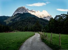
From the Bergdoktorhaus to the Rübezahl-Alm mountain hut and the Carved Figures path to Ellmi’s Zauberwelt.Hiking starting point Tourist Info, Ellmau (800 m)Hiking starting point Tourist Info, Ellmau (800 m)HikingEasy5:30 h15,8 km730 Elevation gainDetails
ABS routeABS routeABS routeBeautiful, Alpine sport climbing with consistent difficulty.Number of rope lengths11 Access time2,0 Alpine climbing routeMulti-rope length difficulty levels7- Details
Winter-Rehbach tourWinter-Rehbach tourWinter-Rehbach tourEnjoy snowy forests and nature in winter.Hiking starting point Tourist Info, Scheffau (738 m)Hiking starting point Tourist Info, Scheffau (738 m)HikingEasy1:45 h3,8 km170 Elevation gainDetails
Connecting trail Ellmau–ScheffauConnecting trail Ellmau–ScheffauConnecting trail Ellmau–ScheffauCross-country skiing and hiking route through a delightful winter landscape via the Auwald and Niederachen districts.Cross-country skiingEasy3,6 km10 Elevation gainDetails
MTB Tour Schleier WaterfallMTB Tour Schleier WaterfallMTB Tour Schleier WaterfallModerate tour to the Schleier Waterfall, a great outdoor experience.Tourist Info, Going (764 m)Tourist Info, Going (764 m)CyclingIntermediate6,6 km410 Elevation gainDetails
Winter walk on HartkaiserWinter walk on HartkaiserWinter walk on HartkaiserA short winter walk on Hartkaiser hrough Ellmi's magical world.Hiking starting point Tourist Info, Ellmau (800 m)Hiking starting point Tourist Info, Ellmau (800 m)HikingEasy0:30 h1,0 km25 Elevation gainDetails
Wilde Gams (Weißbach)Wilde Gams (Weißbach)OpenWilde Gams (Weißbach)Access time0,08333333333333333 Via ferrataDifficulty levelD-E Via ferrara length150,0 m Details
“Moor & more” Törfchen circular hiking route“Moor & more” Törfchen circular hiking route“Moor & more” Törfchen circular hiking routeMoorland hike suitable for children. The elf will help you discover the special inhabitants of the moor.Römerhof, St. Johann (769 m)Römerhof, St. Johann (769 m)HikingEasy1:30 h4,3 km100 Elevation gainDetails
Kaiseralmen snowshoe round-hikeKaiseralmen snowshoe round-hikeKaiseralmen snowshoe round-hikeSnowshoe hike via the Kaiseralmen with starting and finishing at the Gasthof Jägerwirt.Gasthof Jägerwirt, Scheffau (883 m)Gasthof Jägerwirt, Scheffau (883 m)HikingIntermediate3:15 h4,8 km250 Elevation gainDetails
Hartkaiser circuit EllmauHartkaiser circuit EllmauHartkaiser circuit EllmauHartkaiserbahn summit station - Ellmis Zauberwald - Tanzbodensee lake - Hartkaiserbahn summit stationHartkaiser summit station, Ellmau (1,555 m)Hartkaiser summit station, Ellmau (1,555 m)JoggingEasy3,4 km120 Elevation gainDetails
MTB Tour Obere Regalm Mountain HutMTB Tour Obere Regalm Mountain HutMTB Tour Obere Regalm Mountain HutBike tour to the idyllically situated Obere Regalm with a magnificent view.Tourist Info, Going (764 m)Tourist Info, Going (764 m)CyclingIntermediate7,3 km580 Elevation gainDetails
Culinary trailCulinary trailCulinary trailHike via four mountain huts Rübezahl-Alm, Jägerhütte and Hochschwendt.Hiking starting point Tourist Info, Ellmau (800 m)Hiking starting point Tourist Info, Ellmau (800 m)HikingEasy6:15 h14,0 km600 Elevation gainDetails
Kufstein Via FerrataKufstein Via FerrataKufstein Via FerrataA classic amongst the via ferratas on the Wilder Kaiser massif – ideal as a 2-day tour.Access time3,5 Via ferrataDifficulty levelD Via ferrara length675,0 m Details
Astberg circular hiking routeAstberg circular hiking routeAstberg circular hiking routeFamily-friendly, leisurely circular hike around the Astberg mountainAstberg mountain station, Going (1.251 m)Astberg mountain station, Going (1.251 m)HikingEasy0:30 h1,5 km80 Elevation gainDetails
Circuit around GoingCircuit around GoingCircuit around GoingThe circuit around Going is a lengthy and demanding tour with a great variety of different sections.Tourist Information Office, Going (766 m)Tourist Information Office, Going (766 m)JoggingIntermediate1:25 h11,2 km280 Elevation gainDetails
Prama circuitPrama circuitPrama circuitThe Pramarunde circuit - a scenically beautiful circuit at all times of the yearTourist Information Office, Going (766 m)Tourist Information Office, Going (766 m)JoggingEasy0:30 h4,4 km70 Elevation gainDetails
Forstmeile (fitness trail) circuit EllmauForstmeile (fitness trail) circuit EllmauForstmeile (fitness trail) circuit EllmauEllmau hiking info - Church - Gasthof Au - Forstmeile EllmauHiking starting point Tourist Info, Ellmau (800 m)Hiking starting point Tourist Info, Ellmau (800 m)JoggingEasy5,5 km150 Elevation gainDetails
Ellmau golf course circuitEllmau golf course circuitEllmau golf course circuitGentle walking or running course in EllmauHiking starting point Tourist Info, Ellmau (800 m)Hiking starting point Tourist Info, Ellmau (800 m)JoggingEasy0:20 h3,0 km54 Elevation gainDetails
Hochlechen circular routeHochlechen circular routeHochlechen circular routeOld path - now renovated and featuring a pleasant series of ascents and descents.Hiking starting point Bergbahn, Söll (725 m)Hiking starting point Bergbahn, Söll (725 m)HikingIntermediate4:30 h13,5 km470 Elevation gainDetails
Kaiserkrone - approach/descent Ellmau, Wochenbrunner Alm-GruttenhütteKaiserkrone - approach/descent Ellmau, Wochenbrunner Alm-GruttenhütteKaiserkrone - approach/descent Ellmau, Wochenbrunner Alm-GruttenhütteWochenbrunner Alm – GruttenhühtteHiking starting point Wochenbrunner Alm, Ellmau (1,085 m)Gaudeamushütte, Going (1,263 m)HikingIntermediate1:45 h2,6 km530 Elevation gainDetails
Hike to Wochenbrunner AlmHike to Wochenbrunner AlmHike to Wochenbrunner AlmHike from the centre of Ellmau, along trail no. 14, through the "Spatlahner gorge" up to the Wochenbrunner Alm.Hiking starting point Tourist Information Office, Ellmau (800 m)Hiking starting point Tourist Information Office, Ellmau (800 m)HikingEasy1:30 h4,4 km285 Elevation gainDetails
Energy trail circular winterrouteEnergy trail circular winterrouteEnergy trail circular winterrouteWalk through the forest, along the river, back to the village.Hiking starting point Tourist Info, Söll (689 m)Hiking starting point Tourist Info, Söll (689 m)HikingEasy1:45 h6,3 km90 Elevation gainDetails
SchattseitloipeSchattseitloipeSchattseitloipeEnjoy winter silence and an imperial panorama in Söll.parking area Ahornsee, Söll (693 m)parking area Ahornsee, Söll (693 m)Cross-country skiingIntermediate5,3 km80 Elevation gainDetails
Schwendter Sonnenplateau circular winter hiking routeSchwendter Sonnenplateau circular winter hiking routeSchwendter Sonnenplateau circular winter hiking routePicturesque circular route on the sunny side of Going in unspoilt natural surroundings through snow-covered fields offering wonderful views of Going and the Wilder Kaiser region.Hiking starting point Going center (former tourist information Going) (764 m)Hiking starting point Going center (former tourist information Going) (764 m)HikingEasy1:45 h4,8 km80 Elevation gainDetails
Winter circular walk Hintersteiner SeeWinter circular walk Hintersteiner SeeWinter circular walk Hintersteiner SeeBeautiful circular walk around the frozen Lake Hinterstein.Hiking starting point Seestüberl, Scheffau (890 m)Hiking starting point Seestüberl, Scheffau (890 m)HikingEasy2:00 h5,7 km70 Elevation gainDetails
Hintersteiner See circular walkHintersteiner See circular walkHintersteiner See circular walkCrystal-clear mountain lake and magnificent views of the Wilder Kaiser’s western summitsHintersteiner See, Scheffau (890 m)Hintersteiner See, Scheffau (890 m)HikingEasy1:30 h5,2 km130 Elevation gainDetails
Hausbach stream circuitHausbach stream circuitHausbach stream circuitIdeal circuit for beginners to start exercisingTourist Information Office, Going (766 m)Tourist Information Office, Going (766 m)JoggingEasy0:20 h3,1 km75 Elevation gainDetails
From the waterfall to the Kaiser-HochalmFrom the waterfall to the Kaiser-HochalmFrom the waterfall to the Kaiser-HochalmHike across the Alpine pastures and shower in Kaiser water!Hiking starting point Tourist Info, Scheffau (738 m)Hiking starting point Tourist Info, Scheffau (738 m)HikingIntermediate5:30 h11,8 km910 Elevation gainDetails
Pfiffkas routePfiffkas routePfiffkas routeNumber of rope lengths3 Access time2,0 Alpine climbing routeMulti-rope length difficulty levels6+ Details
Marketplace tour SilleralmMarketplace tour SilleralmMarketplace tour SilleralmCulinary tour on the Hohe SalveBergstation Rabennest (1.150 m)Bergstation Rabennest (1.150 m)HikingEasy1:30 h4,0 km160 Elevation gainDetails
Kalkstein bike tourKalkstein bike tourKalkstein bike tourA beautiful tour around the Kalkstein mountain and Pillersee lake.Tourist Info, Going (764 m)Tourist Info, Going (764 m)CyclingIntermediate66,9 km550 Elevation gainDetails
Kletterhalle KaiserBad EllmauKletterhalle KaiserBad EllmauKletterhalle KaiserBad EllmauGrey skies and rain are no excuse: keen climbers have plenty of opportunities to push their boundaries even indoors.Climbing roomDetails
Trailrunning Event Kaiserkrone Trails - routes of all competitionsTrailrunning Event Kaiserkrone Trails - routes of all competitionsTrailrunning Event Kaiserkrone Trails - routes of all competitionsAll routes of the competitions Kaiserkrone Trail - the imperial trail running event in Scheffau am Wilden Kaiser!JoggingDifficult115,0 km8460 Elevation gainDetails
Connection Scheffau-Söll hiking routeConnection Scheffau-Söll hiking routeConnection Scheffau-Söll hiking routeA winter hiking route connects the villages of Söll and Scheffau.Hiking starting point Tourist Info, Scheffau (737 m)Hiking starting point Tourist Info, Söll (689 m)HikingIntermediate2:45 h7,1 km70 Elevation gainDetails
From Söll to Filzalmsee lakeFrom Söll to Filzalmsee lakeFrom Söll to Filzalmsee lakeFollowing the Stampfangerbach stream on the way to Filzalm lakeHiking starting point Bergbahn, Söll (725 m)Hiking starting point Bergbahn, Söll (725 m)HikingIntermediate3:15 h9,0 km620 Elevation gainDetails
Kaiserkrone - stage 3Kaiserkrone - stage 3Kaiserkrone - stage 3Kaindlhütte - Bettlersteig - Anton-Karg-Haus - Hans-Berger-Haus - StripsenjochhausHintersteiner See, Scheffau (889 m)Stripsenjochhaus, St. Johann in Tirol (1,577 m)HikingIntermediate5:00 h9,3 km840 Elevation gainDetails
Kaiserkrone - stage 5Kaiserkrone - stage 5Kaiserkrone - stage 5Gasteig – Wilder-Kaiser-Steig – Ursulablick – Gscheuerkopf – Graspoint-Hochalm – Graspoint-Niederalm – Going, HüttlingGasteig (750 m)Hiking starting point Hüttling, Going (820 m)HikingIntermediate5:15 h10,8 km840 Elevation gainDetails
Kaiseralm round hikeKaiseralm round hikeKaiseralm round hikeShort hike from Jägerwirt to the Kaiseralm with great mountain views.Hiking starting point Jägerwirt, Scheffau (883 m)Hiking starting point Jägerwirt, Scheffau (883 m)HikingEasy1:45 h5,0 km250 Elevation gainDetails
Sonnseitrunde circuit EllmauSonnseitrunde circuit EllmauSonnseitrunde circuit EllmauEllmau hiking info point - Wimm - Riesen - Biedringer Alm - Biedringer Bauernhöfe - Ellmauer Kaiserbad - Ellmau hiking info pointHiking starting point Tourist Info, Ellmau (800 m)Hiking starting point Tourist Info, Ellmau (800 m)JoggingEasy9,8 km400 Elevation gainDetails
E-Bike Roundtour AchleitbergE-Bike Roundtour AchleitbergE-Bike Roundtour AchleitbergVaried round tour with many refreshments and wonderful viewsTourist Information Office, Scheffau (737 m)Tourist Information Office, Scheffau (737 m)CyclingIntermediate23,6 km660 Elevation gainDetails