

Winter walking
Schwendt sun plateau winter circuit
Closed
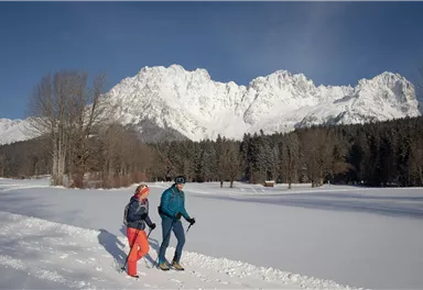
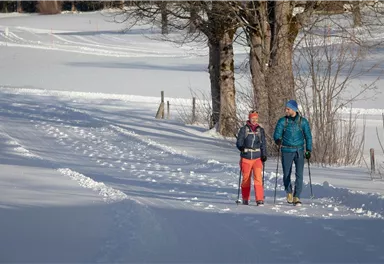
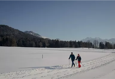
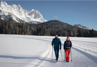
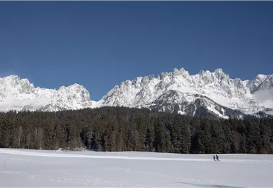
Picturesque circular hiking trail on the sunny side of Going in unspoilt nature - over snow fields with fantastic views of Going aht the Wilder Kaiser.
4,80 km
80 m
01:45 h
Route
4,80 km
80 m
01:45 h
844 m
Starting Point
Hiking starting point Going center (former tourist information Going) (764 m)
End Point
Hiking starting point Going center (former tourist information Going) (764 m)
What to do in an emergency? Call emergency number
140 - Mountain Rescue (Bergrettung)
112 - European Emergency Number
133 - Police
144 - Ambulance
Many routes have rescue points at the hiking signs, which can be used as a clear location identification in an emergency.
The Alpine Club provides tips for optimal preparation for mountain hiking.
SOS-EU-Alp App
The SOS EU ALP app allows you to determine your location (x,y coordinates) via your smartphone. In an emergency, this location data can be sent directly to the responsible control center (Tyrol, South Tyrol or Bavaria).
Important Information
Description
In the middle of the Rettweg settlement, there is a turn-off on the right which you follow until you reach a specially prepared winter trail. Snow-covered trees accompany you through the valley until you take the path uphill to the right and arrive at the Goinger sun plateau around the district ‘Schwendterdörfl’. Enjoy the peace and quiet with a marvellous view of the Wilder...
Best Season
Jan
Feb
Mar
Apr
May
Jun
Jul
Aug
Sep
Oct
Nov
Dec
Skill Level
Endurance
Family-friendly
Loop tour
More information at: www.wilderkaiser.info/mobility
Heading from St. Johann on the B178 road, take the first exit to Going and drive through the town until you see the Tourist Information Office and the hiking starting point on the left-hand side after crossing the bridge.
- Enjoy the marvellous view and the proximity of the Wilder Kaiser.
- The s'Kaiser Ladl is a self-service shop and is open daily from 07:00 a.m. until 10:00 p.m.


Current Weather
Today
2026-05-17
Morning
1 °C
Afternoon
5 °C
Evening
4 °C
Tomorrow
2026-05-18
Morning
6 °C
Afternoon
8 °C
Evening
5 °C
Tuesday
2026-05-19
Morning
2 °C
Afternoon
5 °C
Evening
6 °C
Wednesday
2026-05-20
Morning
5 °C
Afternoon
8 °C
Evening
7 °C
Thursday
2026-05-21
Morning
7 °C
Afternoon
10 °C
Evening
9 °C
Friday
2026-05-22
Morning
9 °C
Afternoon
12 °C
Evening
11 °C
Saturday
2026-05-23
Morning
11 °C
Afternoon
14 °C
Evening
12 °C
Sunday
2026-05-24
Morning
11 °C
Afternoon
13 °C
Evening
12 °C
Monday
2026-05-25
Morning
11 °C
Afternoon
14 °C
Evening
13 °C
Tuesday
2026-05-26
Morning
12 °C
Afternoon
15 °C
Evening
12 °C
Wednesday
2026-05-27
Morning
10 °C
Afternoon
13 °C
Evening
12 °C
Thursday
2026-05-28
Morning
11 °C
Afternoon
15 °C
Evening
13 °C
Friday
2026-05-29
Morning
11 °C
Afternoon
13 °C
Evening
12 °C
Saturday
2026-05-30
Morning
11 °C
Afternoon
13 °C
Evening
12 °C
Last updated at 05/17/2026, 02:00 AM
Contact
Contact
You have questions? We are happy to assist you.


