Oops, tour not found!

We are sorry, your requested page is not available. You can start a new search on this page!

0 Routes and tours

Bergdoktor e-bike tour “From the village square via the doctor’s practice to the Gruberhof”

Bergdoktor e-bike tour “From the village square via the doctor’s practice to the Gruberhof”

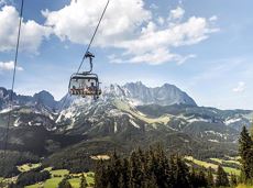
Going church square - Bergdoktor practice Ellmau and Gruberhof Söll. This e-bike tour gives you a chance to enjoy the magnificent mountain panorama at the foot of the Wilder Kaiser and takes you past the three main filming locations of the “Der Bergdoktor” (The Mountain Doctor) TV series.

Going church square

Going church square

Cycling

Intermediate

51,0 km

990 Elevation gain

Schattseittrail

Schattseittrail
Schattseittrail
Schattseittrail

The Schattseit trail, mystical and refreshing in equal measure, is a section of the infamous Kaisermarathon, probably the toughest mountain marathon in the Alps.

Tourismus Info, Söll

Tourismus Info, Söll

Jogging

Easy

12,8 km

330 Elevation gain

Hartkaiserweg trail Ellmau

Hartkaiserweg trail Ellmau

Ellmau village park - Hartkaiserbahn valley station - Bergschenke - Rübezahlalm - Jägerhütte - Hartkaiser summit station

Hiking starting point Tourist Info, Ellmau (800 m)

Hartkaiser summit station, Ellmau (1,555 m)

Jogging

Intermediate

8,2 km

720 Elevation gain

Gentle snowshoe hike in the valley in Going

Gentle snowshoe hike in the valley in Going

Savour the wonder of the winter landscape – experience the winter magic for yourself by crunching through the pristine snow with your snowshoes. Enjoy unique impressions and experiences as you explore the white winter splendour and take in the spectacular view over the surrounding mountain scenery.

Church square, Going (769 m)

Church square, Going (769 m)

Hiking

Easy

1:30 h

2,9 km

110 Elevation gain

November Sun route

November Sun route
November Sun route
November Sun route

This tour is rich in variety and includes slabs, water grooves, as well as a strong overhang and a traverse with an undercling passage.

Number of rope lengths5

Access time1,5

Alpine climbing route

Multi-rope length difficulty levels7-

Hintere Goinger Halt summit tour

Hintere Goinger Halt summit tour

The Hintere Goinger Halt (2,193 m) is considered to be the easiest summit to reach in the Wilder Kaiser.

Hiking starting point Wochenbrunner Alm, Ellmau (1,085 m)

Hiking starting point Wochenbrunner Alm, Ellmau (1,085 m)

Hiking

Difficult

6:30 h

8,9 km

1090 Elevation gain

Schwendter Sonnenplateau circular winter hiking route

Schwendter Sonnenplateau circular winter hiking route

Picturesque circular route on the sunny side of Going in unspoilt natural surroundings through snow-covered fields offering wonderful views of Going and the Wilder Kaiser region.

Hiking starting point Going center (former tourist information Going) (764 m)

Hiking starting point Going center (former tourist information Going) (764 m)

Hiking

Easy

1:45 h

4,8 km

80 Elevation gain

Village tour Going

Village tour Going
Village tour Going
Village tour Going

Discover the most natural place at the Wilder Kaiser.

Hiking starting point Going center (former tourist information Going) (764 m)

Hiking starting point Going center (former tourist information Going) (764 m)

Hiking

Easy

1:15 h

4,2 km

60 Elevation gain

Prama circular hiking route

Prama circular hiking route

Easier and more level circular walk through the sunny district of Prama for walkers or families with pushchairs.

Hiking starting point Going center (former tourist information Going) (764 m)

Hiking starting point Going center (former tourist information Going) (764 m)

Hiking

Easy

1:00 h

3,9 km

60 Elevation gain

Hochlechen circular route

Hochlechen circular route

Old path - now renovated and featuring a pleasant series of ascents and descents.

Hiking starting point Bergbahn, Söll (725 m)

Hiking starting point Bergbahn, Söll (725 m)

Hiking

Intermediate

4:30 h

13,5 km

470 Elevation gain

SkiWelt Panoramic Trail

SkiWelt Panoramic Trail

The highlight for everyone who loves hiking for pleasure - lush Alpine meadows, sparkling mountain lakes and delightful food in the Kitzbühel Alps. And the Bergbahnen Wilder Kaiser - Brixental summer cable cars make the ascent and descent easy.

Astberg, Going

Hochsöll

Hiking

Easy

6:45 h

20,0 km

720 Elevation gain

Prama circular winter hiking route

Prama circular winter hiking route

Sunny walk over snowfields with enchanting landscape. An easy and enjoyable circuit in Going for the whole family.

Hiking starting point Going center (former tourist information Going) (764 m)

Hiking starting point Going center (former tourist information Going) (764 m)

Hiking

Easy

3:00 h

7,9 km

80 Elevation gain

War memorial circular route

War memorial circular route

This pleasant circular walk takes you to Söll’s war memorial in a beautiful section of forest.

Hiking starting point Tourist Info, Söll (689 m)

Hiking starting point Tourist Info, Söll (689 m)

Hiking

Easy

0:30 h

2,1 km

10 Elevation gain

Natural playground Rehbachklamm

Natural playground Rehbachklamm

Hikers, young and old alike, will find in this wild romantic gorge natural playgrounds such as bridges and balancing beams by streams and ponds.

Hiking starting point Tourist Info, Scheffau (738 m)

Hiking starting point Tourist Info, Scheffau (738 m)

Hiking

Easy

1:15 h

3,5 km

130 Elevation gain

Winter-Rehbach tour

Winter-Rehbach tour
Winter-Rehbach tour
Winter-Rehbach tour

Enjoy snowy forests and nature in winter.

Hiking starting point Tourist Info, Scheffau (738 m)

Hiking starting point Tourist Info, Scheffau (738 m)

Hiking

Easy

1:45 h

3,8 km

170 Elevation gain

Treffauer & Tuxeck summit tour

Treffauer & Tuxeck summit tour

Two very demanding, fantastic lookout peaks on the Wilder Kaiser, which are not to be underestimated.

Hiking starting point Wegscheid, Scheffau (883 m)

Hiking starting point Wegscheid, Scheffau (883 m)

Hiking

Difficult

9:00 h

11,0 km

1440 Elevation gain