


 Deutsch
 Nederlands
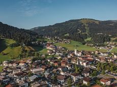
MTB-Tour 364 Walleralm

A short MTB tour to the Walleralm mountain inn, easily combined with other routes.
Parkplatz Pension Maier, Scheffau (925 m)
Parkplatz Walleralm, Söll (685 m)
Cycling
Intermediate
3,3 km
260 Elevation gain
We are sorry, your requested page is not available. You can start a new search on this page!
A short MTB tour to the Walleralm mountain inn, easily combined with other routes.
Parkplatz Pension Maier, Scheffau (925 m)
Parkplatz Walleralm, Söll (685 m)
Cycling
Intermediate
3,3 km
260 Elevation gain

Family hike on Austria’s longest sculpture trail
Hartkaiser summit station, Ellmau (1,555 m)
Rübezahl-Alm, Ellmau (1,174 m)
Hiking
Intermediate
1:00 h
2,5 km
50 Elevation gain

This stage takes hikers to the small town of Kufstein located on the banks of the Inn river – a town which has been celebrated in song and is steeped in history and character. Walkers make their way through the lush and verdant beauty of a pasture paradise with cosy huts and mountain restaurants before stopping for a rest at the Brentenjochhütte hut (delicious “Kiachl” are served every Saturday).
Hintersteiner See
Kufstein
Hiking
Intermediate
4:00 h
12,5 km
160 Elevation gain

A roundhike with family-picnic in a meadow. Tip: bring a pair of binoculars to see the chamois on the rocks.
Hiking starting point Jägerwirt, Scheffau (883 m)
Hiking starting point Jägerwirt, Scheffau (883 m)
Hiking
Intermediate
2:00 h
5,1 km
350 Elevation gain

Intermediate circular hike with breathtaking views on the surrounding mountains. Attention: Trail no 828 is closed due to danger of falling rocks. Detour via path no. 816 and 827 via the Obere Regalm to the Baumgartenköpfl.
Hiking starting point Tannbichl, Going (857 m)
Hiking starting point Tannbichl, Going (857 m)
Hiking
Intermediate
4:45 h
9,8 km
760 Elevation gain

A picturesque mountain hike that leads from the turquoise waters of the most beautiful mountain lake in Tirol up to the rustic Alpine village.
Hiking starting point Seestüberl, Scheffau (890 m)
Hiking starting point Seestüberl, Scheffau (890 m)
Hiking
Intermediate
3:15 h
9,3 km
360 Elevation gain

Past inn, farm and chapel in the Kaiser countryside.
Hiking starting point Going Center (former Tourist informatin Going)
Hiking starting point Going Center (former Tourist informatin Going)
Cross-country skiing
Easy
1,2 km
10 Elevation gain

Short and easy circuit for beginners right next to the village of Söll.
Brunnhof field Söll
Brunnhof field Söll
Cross-country skiing
Easy
0,9 km

Hike from the Kaiserlift mountain station via the Kaindlhütte and Walleralm to Hintersteiner See.
Mountain station Kaiserlift, Kufstein (1256 m)
Hiking starting point Seestüberl, Scheffau (890 m)
Hiking
Intermediate
3:20 h
8,8 km
340 Elevation gain

Experience culinaric highlights for the whole family.
Bergstation Rabennest (1.150 m)
Bergstation Rabennest (1.150 m)
Hiking
Easy
0:40 h
1,7 km
90 Elevation gain

Access time0,08333333333333333
Via ferrata
Difficulty levelD-E
Via ferrara length150,0 m

The Kaiser Marathon - 42 km and 2,300 metres of elevation gain. A welcome challenge for our top athletes!
Söll village centre
Hohe Salve mountain
Jogging
Intermediate
42,0 km
2260 Elevation gain

Access time0,75
Via ferrata
Difficulty levelB-C
Via ferrara length200,0 m

Challenging adventure hike to the Ellmauer Tor
Hiking starting point Wochenbrunner Alm, Ellmau (1,085 m)
Ellmauer Tor, Ellmau (2,001 m)
Hiking
Intermediate
5:00 h
7,7 km
900 Elevation gain

A tour of the main filming locations of the TV series “Der Bergdoktor” (The Mountain Doctor) in Ellmau, with a refreshment stop at the inn used during filming
Hiking starting point Tourist Info, Ellmau (798 m)
Hiking starting point Tourist Info, Ellmau (798 m)
Hiking
Easy
2:15 h
7,5 km
200 Elevation gain

Explore the sunny foot of the Pölven mountain.
Cross-country skiing
Easy
0,9 km

Pleasant hike through forests and across meadows to the sunny plateau of Going and back
Hiking starting point Going center (former tourist information Going) (764 m)
Hiking starting point Going center (former tourist information Going) (764 m)
Hiking
Easy
1:15 h
4,1 km
70 Elevation gain

Kufstein – Brentenjoch – Kaindlhütte
Kaiserlift summit station, Kufstein (1,255 m)
Kaindlhütte, Scheffau (1,293 m)
Hiking
Easy
1:30 h
2,9 km
220 Elevation gain

Approaching from the north, this trail leads through the Steinerne Rinne to the majestic Ellmauer Tor.
Griesner Alm, 988 m
Wochenbrunner Alm, Ellmau (1,085 m)
Hiking
Difficult
5:45 h
8,1 km
1060 Elevation gain

Nice circular hike through Going with visits to numerous chapels.
Hiking starting point Going center (former tourist information Going) (764 m)
Hiking starting point Going center (former tourist information Going) (764 m)
Hiking
Easy
2:45 h
9,3 km
210 Elevation gain
Postkarten circuit Ellmau Ellmau hiking info point – Kapellenpark – Marienkapelle – Ellmau Parish Church
Hiking starting point Tourist Info, Ellmau (800 m)
Hiking starting point Tourist Info, Ellmau (800 m)
Hiking
Easy
0:25 h
1,3 km
40 Elevation gain

2 villages - you fancy quiete and a very rural athmosphere - Scheffau is the place to go, or, you opt for a great variety of gastronomy and restaurants - then Söll is good to go. No matter how, your decision is always superb. The ski hiking route is purely flat, which also means it's great for everybody.
restaurant Oberstegen, Söll
village, Scheffau
Cross-country skiing
Easy
1,4 km
15 Elevation gain

Varied beginner trail round between the Kaiser towns of Ellmau and Going.
Wanderstartplatz Tourismus Info, Ellmau
Wanderstartplatz Tourismus Info, Ellmau
Jogging
Easy
10,2 km
520 Elevation gain

The varied loop takes you on leisurely valley cycle paths as well as a mountain evaluation on the MTB routes 265 and 350 once around the Hohe Salve lookout mountain.
Tourismus Info, Söll
Tour
Cycling
Intermediate
36,5 km
880 Elevation gain
Cozy winter walk through the snowy witch water.
Mountain station gondola Hexenwasser, Söll (1,150 m)
Mountain station gondola Hexenwasser, Söll (1,150 m)
Hiking
Easy
0:30 h
1,2 km
45 Elevation gain

Ellmau hiking info - Gasthof Au - Forstmeile Ellmau
District "Steinerner Tisch", Ellmau
District "Steinerner Tisch", Ellmau
Jogging
Easy
1,9 km
75 Elevation gain

Ellmau hiking info point - Gasthof Au - Ellmauer Hof - Haflingertränke - Auwald - Ellmau hiking info point
Hiking starting point Tourist Info, Ellmau (800 m)
Hiking starting point Tourist Info, Ellmau (800 m)
Jogging
Easy
1:30 h
9,8 km
300 Elevation gain

Snowshoe hike via the Kaiseralmen with starting and finishing at the Gasthof Jägerwirt.
Gasthof Jägerwirt, Scheffau (883 m)
Gasthof Jägerwirt, Scheffau (883 m)
Hiking
Intermediate
3:15 h
4,8 km
250 Elevation gain

Picture-postcard panoramic scenery to Hintersteiner See lake, a natural gem.
Villag Center, Söll (689 m)
Hintersteiner See Lake, Scheffau (889 m)
Cycling
Intermediate
9,4 km
430 Elevation gain

On the north side up to the Ellmauer Halt summit 2,344 m.
Access time4,5
Via ferrata
Difficulty levelB-C
Via ferrara length2000,0 m

Difficult piste tour via the downhill, route no. 40a to Hochsöll Hexenwasser mountain station & further on via the Keat downhill route no. 43 to the Keat alpine pastures.
Cable Car Söll, ski touring car park
Mountain station, Hexenwasser gondola or Keat Almen
Ski tour
Difficult
1:30 h
4,0 km
762 Elevation gain

Gruttenhütte - Kaiser-Hochalm - Steiner-Hochalm - Hinterschießling Alm - Rehbachklamm - Scheffau, Dorf
Gruttenhütte, Ellmau (1,620 m)
Scheffau village (889 m)
Hiking
Intermediate
4:30 h
11,4 km
190 Elevation gain

The best hiking routes from village centre Scheffau to Lake Hinterstein.
Community Hall, Scheffau (740 m)
Hintersteiner See, Scheffau (890 m)
Hiking
Intermediate
1:30 h
4,5 km
240 Elevation gain

Enjoy winter silence and an imperial panorama in Söll.
parking area Ahornsee, Söll (693 m)
parking area Ahornsee, Söll (693 m)
Cross-country skiing
Intermediate
5,3 km
80 Elevation gain

The best seat in the house for a view of the Wilder Kaiser!
Tourist Information Office, Going (766 m)
Tourist Information Office, Going (766 m)
Cycling
Intermediate
2:00 h
7,5 km
350 Elevation gain

Pleasant high-altitude walk taking in the mountain and Astbergsee lake - the mirror of the Wilder Kaiser!
Blattlalm, Going (1,246 m)
Blattlalm, Going (1,246 m)
Hiking
Easy
0:40 h
1,7 km
80 Elevation gain

Number of rope lengths6
Access time2,0
Alpine climbing route
Multi-rope length difficulty levels6+

A classic style trail connects the villages of Söll and Scheffau for cross-country skiing in winter.
Parkplatz Ahornsee, Söll (693 m)
village, Scheffau
Cross-country skiing
Intermediate
5,5 km
65 Elevation gain

Ellmau village park - Hartkaiserbahn valley station - Bergschenke - Rübezahlalm - Jägerhütte - Hartkaiser summit station
Hiking starting point Tourist Info, Ellmau (800 m)
Hartkaiser summit station, Ellmau (1,555 m)
Jogging
Intermediate
8,2 km
720 Elevation gain

Picturesque circular route on the sunny side of Going in unspoilt natural surroundings through snow-covered fields offering wonderful views of Going and the Wilder Kaiser region.
Hiking starting point Going center (former tourist information Going) (764 m)
Hiking starting point Going center (former tourist information Going) (764 m)
Hiking
Easy
1:45 h
4,8 km
80 Elevation gain