

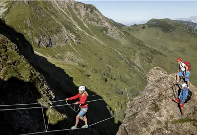
Via ferrata
Via ferrata Marokka Fieberbrunn
Closed
200,00 m


Route
200,00 m
What to do in an emergency? Call emergency number
140 - Mountain Rescue (Bergrettung)
112 - European Emergency Number
133 - Police
144 - Ambulance
Many routes have rescue points at the hiking signs, which can be used as a clear location identification in an emergency.
The Alpine Club provides tips for optimal preparation for mountain hiking.
SOS-EU-Alp App
The SOS EU ALP app allows you to determine your location (x,y coordinates) via your smartphone. In an emergency, this location data can be sent directly to the responsible control center (Tyrol, South Tyrol or Bavaria).
Description
Best Season
Jan
Feb
Mar
Apr
May
Jun
Jul
Aug
Sep
Oct
Nov
Dec
Climbing time (guideline)
2,0
Exposure N
Altitude difference via ferrata
130
Walk time to entry point (guideline)
0,75
Walking time descent (guideline)
0,75
By train: free train connection from Wörgl to Hochfilzen (regional trains) with guest card. Fieberbrunn railway station. Walking time to bus stop Fieberbrunn Rosenegg Steig B direction Bergbahn approx. 10 min.
Current Weather
Today
2026-05-22
Morning
9 °C
Afternoon
14 °C
Evening
13 °C
Tomorrow
2026-05-23
Morning
13 °C
Afternoon
16 °C
Evening
15 °C
Sunday
2026-05-24
Morning
14 °C
Afternoon
17 °C
Evening
16 °C
Monday
2026-05-25
Morning
15 °C
Afternoon
18 °C
Evening
17 °C
Tuesday
2026-05-26
Morning
16 °C
Afternoon
18 °C
Evening
17 °C
Wednesday
2026-05-27
Morning
14 °C
Afternoon
16 °C
Evening
13 °C
Thursday
2026-05-28
Morning
10 °C
Afternoon
13 °C
Evening
11 °C
Friday
2026-05-29
Morning
10 °C
Afternoon
13 °C
Evening
12 °C
Saturday
2026-05-30
Morning
11 °C
Afternoon
14 °C
Evening
12 °C
Sunday
2026-05-31
Morning
11 °C
Afternoon
14 °C
Evening
12 °C
Monday
2026-06-01
Morning
12 °C
Afternoon
13 °C
Evening
11 °C
Tuesday
2026-06-02
Morning
11 °C
Afternoon
14 °C
Evening
12 °C
Wednesday
2026-06-03
Morning
12 °C
Afternoon
12 °C
Evening
11 °C
Thursday
2026-06-04
Morning
11 °C
Afternoon
12 °C
Evening
11 °C
Last updated at 05/22/2026, 02:00 PM
Contact
Contact
You have questions? We are happy to assist you.


