


 Deutsch
 Nederlands
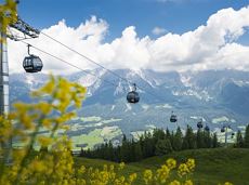
Drei-Käse-Hochtour route

There are 3 steep rises which are moderable with e-bikes.
Cable car valley station, Söll (725 m)
Au Hoch-Alm, Söll (1.600 m)
Cycling
Intermediate
8,9 km
860 Elevation gain
We are sorry, your requested page is not available. You can start a new search on this page!
There are 3 steep rises which are moderable with e-bikes.
Cable car valley station, Söll (725 m)
Au Hoch-Alm, Söll (1.600 m)
Cycling
Intermediate
8,9 km
860 Elevation gain

Gaudeamushütte - Ellmauer Tor - Klammlweg - Gruttenhütte
Gaudeamushütte, Going (1,263 m)
Gruttenhütte, Ellmau (1,620 m)
Hiking
Intermediate
4:45 h
5,9 km
990 Elevation gain

Family hike on Austria’s longest sculpture trail
Hartkaiser summit station, Ellmau (1,555 m)
Rübezahl-Alm, Ellmau (1,174 m)
Hiking
Intermediate
1:00 h
2,5 km
50 Elevation gain

Hike to the Gruttenhütte with great views to the Ellmauer Halt and the entire region.
Hiking starting point Tourist Info, Scheffau (738 m)
Gruttenhütte, Ellmau (1,620 m)
Hiking
Intermediate
6:30 h
16,4 km
990 Elevation gain

A unique hike to the highest mountain hut in the Wilder Kaiser region featuring a panoramic view.
Hiking starting point Going center (former tourist information Going) (764 m)
Hiking starting point Going center (former tourist information Going) (764 m)
Hiking
Intermediate
5:45 h
14,2 km
860 Elevation gain

Ellmau Tourist Information Office - football pitch - Ellmauer Hof - KaiserBad - Hausbach farms - Ellmau Tourist Information Office
Tourist Information Office, Ellmau (820 m)
Tourist Information Office, Ellmau (820 m)
Cycling
Easy
8,2 km
110 Elevation gain

Head through well-shaded forests of green to reach the Ellmau Stone Circle. This is a place with a special energy, making it an inviting option for taking some time to relax.
Hiking starting point Wochenbrunner Alm, Ellmau (1,085 m)
Hiking starting point Wochenbrunner Alm, Ellmau (1,085 m)
Hiking
Intermediate
1:00 h
2,4 km
120 Elevation gain

A relaxing hike towards the village center.
Hiking starting point Alpenschlössl, Söll (762 m)
Hiking starting point Alpenschlössl Söll (762 m)
Hiking
Easy
0:55 h
3,2 km
20 Elevation gain

Comfortable round with a magnificent view of the Hohe Salve.
Mountain station gondola Hexenwasser, Söll (1,150 m)
Mountain station gondola Hexenwasser, Söll (1,150 m)
Hiking
Easy
0:35 h
1,8 km
50 Elevation gain

Exciting adventure stations for family tobogganing on the Hohe Salve.
Cable car valley station, Söll (725 m)
Cable car valley station, Söll (725 m)
Tobogganing
Easy
4,0 km

Cozy winter walk through the snowy "Hexenwasser" and amazing views of the Hohe Salve.
Mountain station gondola Hexenwasser, Söll (1,150 m)
Mountain station gondola Hexenwasser, Söll (1,150 m)
Hiking
0:50 h
2,0 km
70 Elevation gain

Ellmau hiking info - Church - Gasthof Au - Forstmeile Ellmau
Hiking starting point Tourist Info, Ellmau (800 m)
Hiking starting point Tourist Info, Ellmau (800 m)
Jogging
Easy
5,5 km
150 Elevation gain

Cozy winter tour in Hochsöll with lift support, refreshments and view to the Hohe Salve.
Mountain station gondola Hexenwasser, Söll (1,150 m)
Mountain station gondola Hexenwasser, Söll (1,150 m)
Hiking
1:30 h
3,2 km
100 Elevation gain

With the Söller Zehner (1st competition in the Tour de Tirol) the circuit is run three times!
Hiking starting point Tourist Info, Söll (689 m)
Hiking starting point Tourist Info, Söll (689 m)
Jogging
Easy
3,3 km
80 Elevation gain
 Open
OpenAccess time0,16666666666666666
Via ferrata
Difficulty levelB-C
Via ferrara length200,0 m
Hartkaiserbahn summit station - Ellmis Zauberwald - Tanzbodensee lake - Hartkaiserbahn summit station
Hartkaiser summit station, Ellmau (1,555 m)
Hartkaiser summit station, Ellmau (1,555 m)
Jogging
Easy
3,4 km
120 Elevation gain

Gruttenhütte - Kaiser-Hochalm - Steiner-Hochalm - Hinterschießling Alm - Rehbachklamm - Scheffau, Dorf
Gruttenhütte, Ellmau (1,620 m)
Scheffau village (889 m)
Hiking
Intermediate
4:30 h
11,4 km
190 Elevation gain

Short circular walk at the snow-white Brandstadl mountain with panorama view.
Brandstadlbahn summit station, Scheffau (1,643 m)
Brandstadlbahn summit station, Scheffau (1,643 m)
Hiking
0:30 h
1,3 km
40 Elevation gain
 Open
OpenThe short via ferrata is ideal for beginners.
Access time0,9166666666666666
Via ferrata
Difficulty levelB-C
Via ferrara length50,0 m

Details about the Kaiserkrone Trail - Trailrunning Event at: www.kaiserkrone.run
Start & Finish - village center of Scheffau (732 m), address: Dorf 45, 6351 Scheffau
Start & Finish - village center of Scheffau (732 m), address: Dorf 45, 6351 Scheffau
Jogging
Difficult
56,0 km
3640 Elevation gain

Experience culinaric highlights for the whole family.
Bergstation Rabennest (1.150 m)
Bergstation Rabennest (1.150 m)
Hiking
Easy
0:40 h
1,7 km
90 Elevation gain

Is it about the journey or the destination? Well, one of the destinations of this stage is definitely the Hintersteiner See lake and its views. Surrounded by stunning mountain vistas, dwarf pine scrubland and beech forests, the lake is one of the cleanest and most beautiful mountain lakes in Tirol. The private pristine gem covers 56 hectares and measures 36 metres at its deepest point. With this picture-perfect backdrop, hikers will complete the remaining distance to the Kaindlhütte hut in no time.
Gaudeamushütte
Hintersteiner See
Hiking
Intermediate
6:30 h
15,1 km
888 Elevation gain

A run during which you can enjoy peace and quiet in the great outdoors.
Starting point Scheffau Tourist Information Office (752 m)
Starting point Scheffau Tourist Information Office (752 m)
Jogging
Intermediate
6,1 km
260 Elevation gain

Refreshing walk through the Kneipp circuit and adventures in the Rehbachklamm gorge
Hiking starting point Tourist Info, Scheffau (738 m)
Hiking starting point Tourist Info, Scheffau (738 m)
Hiking
Intermediate
2:00 h
7,1 km
330 Elevation gain

Looping the village of Söll, the sight seeing hike!
Hiking starting point Tourist Info, Söll (689 m)
Hiking starting point Tourist Info, Söll (689 m)
Hiking
Easy
1:00 h
3,7 km
50 Elevation gain

From the flowery village to the water jewel of the Alps.
Hiking starting point Franzlhof, Söll (703 m)
Seestüberl restaurant, Hintersteiner See, Scheffau (890 m)
Hiking
Intermediate
3:15 h
9,5 km
460 Elevation gain

34 magnificent routes with a fantastic panoramic view of the summits.
Route number34
Access time1,5
Sport climbing

Sunny walk over snow fields with a magical winter landscape. An easy and enjoyable circuit in Going for the whole family.
Hiking starting point Going center (former tourist information Going) (764 m)
Hiking starting point Going center (former tourist information Going) (764 m)
Hiking
3:00 h
7,9 km
80 Elevation gain

A roundhike with family-picnic in a meadow. Tip: bring a pair of binoculars to see the chamois on the rocks.
Hiking starting point Jägerwirt, Scheffau (883 m)
Hiking starting point Jägerwirt, Scheffau (883 m)
Hiking
Intermediate
2:00 h
5,1 km
350 Elevation gain

By bike through the culinary region Wilder Kaiser.
anywhere along the tour
anywhere along the tour
Cycling
Intermediate
38,3 km
560 Elevation gain

A challenging circular mountainbike tour with plenty of welcoming refreshment stops.
Village Center, Söll (703 m)
Village Center, Söll (703 m)
Cycling
Intermediate
28,5 km
950 Elevation gain

Embark on a sunny cross-country safari in the snowfields around the Sölllandl.
Spar super market Söll
Spar super market Söll
Cross-country skiing
Intermediate
5,9 km
70 Elevation gain

A demanding mountain tour with some ferrata passages up to the highest summit in the Wilder Kaiser (2,344 m).
Hiking starting point Wochenbrunner Alm, Ellmau (1,085 m)
Hiking starting point Wochenbrunner Alm, Ellmau (1,085 m)
Hiking
Difficult
7:30 h
9,3 km
1250 Elevation gain

A winter hiking route connects the villages of Söll and Scheffau.
Hiking starting point Tourist Info, Scheffau (737 m)
Hiking starting point Tourist Info, Söll (689 m)
Hiking
2:45 h
7,1 km
70 Elevation gain
 Open
OpenAccess time0,75
Via ferrata
Difficulty levelB-C
Via ferrara length200,0 m

The Sunnseit circuit lives up to its name - this sunny circular hike leads through a varied landscape with fantastic views of Söll, the Wilder Kaiser, the Hohe Salve and the Pölven massif.
Hiking starting point Franzlhof, Söll (703 m)
Hiking starting point Franzlhof, Söll (703 m)
Hiking
Easy
2:15 h
7,3 km
180 Elevation gain

A circuit around the mountain that the locals love for its great view.
Hiking starting point Franzlhof, Söll (703 m)
Hiking starting point Franzlhof, Söll (703 m)
Hiking
Intermediate
6:00 h
17,8 km
670 Elevation gain

Experience impressive low and panoramic views in the unique rocky scenery of the legendary "Wild Castle", as this area is known according to legend thanks to its many turrets, peaks, hollows and balconies.
Wochenbrunner Alm, Ellmau (1.085 m)
Wochenbrunner Alm, Ellmau (1.085 m)
Hiking
Difficult
4:15 h
6,3 km
710 Elevation gain
 Open
OpenAccess time0,08333333333333333
Via ferrata
Difficulty levelA/B
Via ferrara length180,0 m

Gruttenhütte - Kaiser-Hochalm - Steiner-Hochalm - Jägersteig - Walleralm - Hochegg - Kaindlhütte
Gruttenhütte, Ellmau (1,620 m)
Hintersteiner See, Scheffau (889 m)
Hiking
Intermediate
5:30 h
13,5 km
560 Elevation gain