


 Deutsch
 Nederlands
Marketplace bike tour

By bike through the culinary region Wilder Kaiser.
anywhere along the tour
anywhere along the tour
Cycling
Intermediate
38,3 km
560 Elevation gain
We are sorry, your requested page is not available. You can start a new search on this page!
By bike through the culinary region Wilder Kaiser.
anywhere along the tour
anywhere along the tour
Cycling
Intermediate
38,3 km
560 Elevation gain
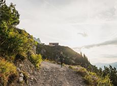
Gruttenhütte - Kaiser-Hochalm - Steiner-Hochalm - Jägersteig - Walleralm - Hochegg - Kaindlhütte
Gruttenhütte, Ellmau (1,620 m)
Hintersteiner See, Scheffau (889 m)
Hiking
Intermediate
5:30 h
13,5 km
560 Elevation gain

The Kaiser Marathon - 42 km and 2,300 metres of elevation gain. A welcome challenge for our top athletes!
Söll village centre
Hohe Salve mountain
Jogging
Intermediate
42,0 km
2260 Elevation gain

Difficult piste tour via the downhill, route no. 40a to Hochsöll Hexenwasser mountain station & further on via the Keat downhill route no. 43 to the Keat alpine pastures.
Cable Car Söll, ski touring car park
Mountain station, Hexenwasser gondola or Keat Almen
Ski tour
Difficult
1:30 h
4,0 km
762 Elevation gain

Two very demanding, fantastic lookout peaks on the Wilder Kaiser, which are not to be underestimated.
Hiking starting point Wegscheid, Scheffau (883 m)
Hiking starting point Wegscheid, Scheffau (883 m)
Hiking
Difficult
9:00 h
11,0 km
1440 Elevation gain
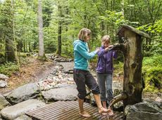
Refreshing walk through the Kneipp facilities and adventures in the Rehbachklamm gorge
Hiking starting point Tourist Info, Scheffau (738 m)
Hiking starting point Tourist Info, Scheffau (738 m)
Hiking
Intermediate
2:00 h
7,1 km
330 Elevation gain

Number of rope lengths4
Access time2,0
Alpine climbing route
Multi-rope length difficulty levels7-
Ellmau hiking info point - Wimm - Riesen - Biedringer Alm - Biedringer Bauernhöfe - Ellmauer Kaiserbad - Ellmau hiking info point
Hiking starting point Tourist Info, Ellmau (800 m)
Hiking starting point Tourist Info, Ellmau (800 m)
Jogging
Easy
9,8 km
400 Elevation gain

A short MTB tour to the Walleralm mountain inn, easily combined with other routes.
Parkplatz Pension Maier, Scheffau (925 m)
Parkplatz Walleralm, Söll (685 m)
Cycling
Intermediate
3,3 km
260 Elevation gain

Walk through the forest, along the river, back to the village.
Hiking starting point Tourist Info, Söll (689 m)
Hiking starting point Tourist Info, Söll (689 m)
Hiking
Easy
1:45 h
6,3 km
90 Elevation gain

A beautiful tour around the Kalkstein mountain and Pillersee lake.
Tourist Info, Going (764 m)
Tourist Info, Going (764 m)
Cycling
Intermediate
66,9 km
550 Elevation gain

Sunny walk over snowfields with enchanting landscape. An easy and enjoyable circuit in Going for the whole family.
Hiking starting point Going center (former tourist information Going) (764 m)
Hiking starting point Going center (former tourist information Going) (764 m)
Hiking
Easy
3:00 h
7,9 km
80 Elevation gain

Gentle walking or running course in Ellmau
Hiking starting point Tourist Info, Ellmau (800 m)
Hiking starting point Tourist Info, Ellmau (800 m)
Jogging
Easy
0:20 h
3,0 km
54 Elevation gain

The best hiking routes from village centre Scheffau to Lake Hinterstein.
Community Hall, Scheffau (740 m)
Hintersteiner See, Scheffau (890 m)
Hiking
Intermediate
1:30 h
4,5 km
240 Elevation gain

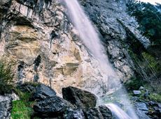
Short hike to the waterfall in the Breuergraben along the Schwarzache.
Brandstadlbahn valley station, Scheffau (681 m)
Brandstadlbahn valley station, Scheffau (681 m)
Hiking
Easy
1:00 h
3,0 km
150 Elevation gain

The Pramarunde circuit - a scenically beautiful circuit at all times of the year
Tourist Information Office, Going (766 m)
Tourist Information Office, Going (766 m)
Jogging
Easy
0:30 h
4,4 km
70 Elevation gain

Experience impressive low and panoramic views in the unique rocky scenery of the legendary "Wild Castle", as this area is known according to legend thanks to its many turrets, peaks, hollows and balconies.
Wochenbrunner Alm, Ellmau (1.085 m)
Wochenbrunner Alm, Ellmau (1.085 m)
Hiking
Difficult
3:45 h
6,3 km
630 Elevation gain

Explore the village Scheffau on a circuit run
Starting point Scheffau Tourist Information Office (752 m)
Starting point Scheffau Tourist Information Office (752 m)
Jogging
Easy
5,6 km
120 Elevation gain

Off the beaten track up to the Köpfing farmhouse. “Der Bergdoktor” (The Mountain Doctor) is a famous German-Austrian TV series, which is produced in the Wilder Kaiser region.
Bergdoktor parking lot, Söll
Bergdoktor parking lot, Söll
Hiking
Easy
3:00 h
8,4 km
370 Elevation gain

Extended walk through the landscape of Scheffau and Söll
Hiking starting point Tourist Info, Scheffau (738 m)
Hiking starting point Tourist Info, Scheffau (738 m)
Hiking
Easy
3:30 h
8,8 km
210 Elevation gain
A gentle walk to ancient farmsteads with a refreshment stop in a welcoming inn.
Hiking starting point Tourist Info, Scheffau (738 m)
Hiking starting point Tourist Info, Scheffau (738 m)
Hiking
Easy
1:30 h
3,8 km
80 Elevation gain

Snowshoe hike via the Kaiseralmen with starting and finishing at the Gasthof Jägerwirt.
Gasthof Jägerwirt, Scheffau (883 m)
Gasthof Jägerwirt, Scheffau (883 m)
Hiking
Intermediate
3:15 h
4,8 km
250 Elevation gain

Moderate tour to the Schleier Waterfall, a great outdoor experience.
Tourist Info, Going (764 m)
Tourist Info, Going (764 m)
Cycling
Intermediate
6,6 km
410 Elevation gain

A hike on varied paths around the Achleitberg.
Hiking starting point Tourist Info, Scheffau (738 m)
Hiking starting point Tourist Info, Scheffau (738 m)
Hiking
Intermediate
5:45 h
18,0 km
540 Elevation gain

Number of rope lengths12
Access time2,0
Alpine climbing route
Multi-rope length difficulty levels6+ (6-/A0)
Mountain tour to the extreme climbers’ training rock and spectacle of nature with refreshment stop at the Graspoint-Niederalm.
Hiking starting point Hüttling, Going (820 m)
Hiking starting point Hüttling, Going (820 m)
Hiking
Intermediate
3:00 h
5,5 km
520 Elevation gain

Ellmau Tourist Information Office - football pitch - Ellmauer Hof - KaiserBad - Hausbach farms - Ellmau Tourist Information Office
Tourist Information Office, Ellmau (820 m)
Tourist Information Office, Ellmau (820 m)
Cycling
Easy
8,2 km
110 Elevation gain

Nice circular hike through Going with visits to numerous chapels.
Hiking starting point Going center (former tourist information Going) (764 m)
Hiking starting point Going center (former tourist information Going) (764 m)
Hiking
Easy
2:45 h
9,3 km
210 Elevation gain

With the Söller Zehner (1st competition in the Tour de Tirol) the circuit is run three times!
Hiking starting point Tourist Info, Söll (689 m)
Hiking starting point Tourist Info, Söll (689 m)
Jogging
Easy
3,3 km
80 Elevation gain

Savour the wonder of the winter landscape – experience the winter magic for yourself by crunching through the pristine snow with your snowshoes. Enjoy unique impressions and experiences as you explore the white winter splendour and take in the spectacular view over the surrounding mountain scenery.
Church square, Going (769 m)
Church square, Going (769 m)
Hiking
Easy
1:30 h
2,9 km
110 Elevation gain

Approaching from the north, this trail leads through the Steinerne Rinne to the majestic Ellmauer Tor.
Griesner Alm, 988 m
Wochenbrunner Alm, Ellmau (1,085 m)
Hiking
Difficult
5:45 h
8,1 km
1060 Elevation gain

A classic amongst the via ferratas on the Wilder Kaiser massif – ideal as a 2-day tour.
Access time3,5
Via ferrata
Difficulty levelD
Via ferrara length675,0 m
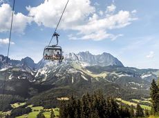
The highlight for everyone who loves hiking for pleasure - lush Alpine meadows, sparkling mountain lakes and delightful food in the Kitzbühel Alps. And the Bergbahnen Wilder Kaiser - Brixental summer cable cars make the ascent and descent easy.
Astberg, Going
Hochsöll
Hiking
Easy
6:45 h
20,0 km
720 Elevation gain

The best seat in the house for a view of the Wilder Kaiser!
Hiking starting point Going center (former tourist information Going) (764 m)
Hiking starting point Going center (former tourist information Going) (764 m)
Hiking
Easy
2:15 h
5,8 km
290 Elevation gain

Cross-country skiing
Easy
1,0 km

Stripsenjochhaus – Eggersteig – Steinerne Rinne – Ellmauer Tor – Jubiläumssteig – Gruttenhütte
Stripsenjochhaus, St. Johann in Tirol (1,577 m)
Gaudeamushütte, Going (1,263 m)
Hiking
Difficult
5:00 h
6,3 km
590 Elevation gain
Hike via four mountain huts Rübezahl-Alm, Jägerhütte and Hochschwendt.
Hiking starting point Tourist Info, Ellmau (800 m)
Hiking starting point Tourist Info, Ellmau (800 m)
Hiking
Easy
6:15 h
14,0 km
600 Elevation gain

Grey skies and rain are no excuse: keen climbers have plenty of opportunities to push their boundaries even indoors.
Climbing room
A beautiful easy hike at the foot of the Wilder Kaiser
Hiking starting point Tourist Info, Ellmau (800 m)
Hiking starting point Tourist Info, Ellmau (800 m)
Hiking
Easy
1:45 h
5,9 km
60 Elevation gain

This tour is rich in variety and includes slabs, water grooves, as well as a strong overhang and a traverse with an undercling passage.
Number of rope lengths5
Access time1,5
Alpine climbing route
Multi-rope length difficulty levels7-