


 Deutsch
 Nederlands
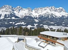
Bichlloipe

Cross-country skiing on an isolated plateau, surrounded by forest and winter meadows.
Cross-country skiing
Easy
1,3 km
30 Elevation gain
We are sorry, your requested page is not available. You can start a new search on this page!
Cross-country skiing on an isolated plateau, surrounded by forest and winter meadows.
Cross-country skiing
Easy
1,3 km
30 Elevation gain
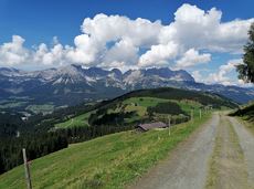
A must for hikers in Söll - local history and culinary delights on the sunny side.
Hiking starting point Franzlhof, Söll (703 m)
Hiking starting point Franzlhof, Söll (703 m)
Hiking
Easy
4:00 h
12,0 km
420 Elevation gain

Demanding mountain tour to the Kleines Törl pass, the little "brother" of the Ellmauer Tor in the Ostkaiser.
Hiking starting point Tannbichl, Going (855 m)
Hiking starting point Tannbichl, Going (855 m)
Hiking
Difficult
8:00 h
12,0 km
1260 Elevation gain

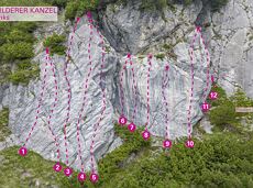
This is a very well secured sport climbing route in excellent rock conditions.
Number of rope lengths10
Access time2,0
Alpine climbing route
Multi-rope length difficulty levels8+

A short winter walk on Hartkaiser hrough Ellmi's magical world.
Hiking starting point Tourist Info, Ellmau (800 m)
Hiking starting point Tourist Info, Ellmau (800 m)
Hiking
Easy
0:30 h
1,0 km
25 Elevation gain

Difficult piste tour via the downhill, route no. 40a to Hochsöll Hexenwasser mountain station & further on via the Keat downhill route no. 43 to the Keat alpine pastures.
Cable Car Söll, ski touring car park
Mountain station, Hexenwasser gondola or Keat Almen
Ski tour
Difficult
1:30 h
4,0 km
762 Elevation gain

Along with the Murmeltierfelsen and Gamsfelsen, there are a total of 17 climbing routes of difficulty levels 3 to 6b+ near the Gaudeamushütte mountain hut.
Route number19
Access time1,0
Sport climbing

Picturesque circular route on the sunny side of Going in unspoilt natural surroundings through snow-covered fields offering wonderful views of Going and the Wilder Kaiser region.
Hiking starting point Going center (former tourist information Going) (764 m)
Hiking starting point Going center (former tourist information Going) (764 m)
Hiking
Easy
1:45 h
4,8 km
80 Elevation gain

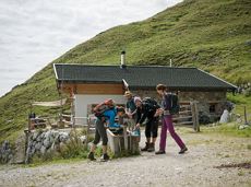
Wochenbrunner Alm – Gruttenhühtte
Hiking starting point Wochenbrunner Alm, Ellmau (1,085 m)
Gaudeamushütte, Going (1,263 m)
Hiking
Intermediate
1:45 h
2,6 km
530 Elevation gain

Number of rope lengths5
Access time2,0
Alpine climbing route
Multi-rope length difficulty levels7+
34 magnificent routes with a fantastic panoramic view of the summits.
Route number34
Access time1,5
Sport climbing
Over hill and dale through idyllic nature up to the Rauhen Kopf.
Astberg Bergstation
Astberg Bergstation
Hiking
Intermediate
4:45 h
13,1 km
620 Elevation gain

Enjoy winter silence and an imperial panorama in Söll.
parking area Ahornsee, Söll (693 m)
parking area Ahornsee, Söll (693 m)
Cross-country skiing
Intermediate
5,3 km
80 Elevation gain

From Hochsöll (Hexenwasser theme park) and Filzalmsee lake to Brixen im Thale.
Hexenwasser theme park Söll Hohe Salve
Brixen im Thale valley station
Cycling
Intermediate
9,3 km
200 Elevation gain

The Kaiser Marathon - 42 km and 2,300 metres of elevation gain. A welcome challenge for our top athletes!
Söll village centre
Hohe Salve mountain
Jogging
Intermediate
42,0 km
2260 Elevation gain

Very demanding round tour to the two eastern peaks in the Wilder Kaiser.
Hiking starting point Tannbichl, Going (857 m)
Hiking starting point Tannbichl, Going (857 m)
Hiking
Difficult
9:00 h
13,0 km
1570 Elevation gain

Access time0,16666666666666666
Via ferrata
Difficulty levelB-C
Via ferrara length0,2 m

Hartkaiserbahn summit station - Ellmis Zauberwald - Tanzbodensee lake - Hartkaiserbahn summit station
Hartkaiser summit station, Ellmau (1,555 m)
Hartkaiser summit station, Ellmau (1,555 m)
Jogging
Easy
3,4 km
120 Elevation gain

Winter hike with picturesque views of the Wilder Kaiser to the 'Wolfsegg' plateau
Hiking starting point Going center (former tourist information Going) (764 m)
Hiking starting point Going center (former tourist information Going) (764 m)
Hiking
Easy
1:30 h
4,0 km
65 Elevation gain

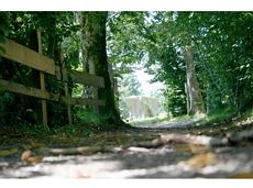
Ancient path of the romans - a better stroll.
Hiking starting point Tourist Info, Söll (689 m)
Hiking starting point Tourist Info, Söll (689 m)
Hiking
Easy
1:00 h
3,0 km
55 Elevation gain
Sturdy boots will help keep your ankles and feet happy on this hike, full of the best things Tirol has to offer: well-maintained trails, wildflowers galore and waterfalls beckon the adventurous hiker ready for a strenuous climb with breathtaking views of lofty Wilder Kaiser Mountain Range as your reward. The nature reserve’s landscape will win you over with its diverse beauty. The pasture regions are covered with soft grassy meadows, and hikers are greeted by lofty Wilder Kaiser Mountain Range with rugged Maukspitze, Ackerlspitze, Regalpspitze and Törlspitze Peaks, all “Two-Thousanders” that average 2,000 metres altitude. Trailhead is Rummlerhof Inn, northwest of the village centre of St. Johann. After a successful first segment, why not take a rest at Gaudeamus Hut, raise your glass and sing: “Gaudeamus igitur – Let us be happy!” For many hikers this is far enough, contentment has already set in. Adventurous souls continue on the trail that works its way up across Klamml Gorge to Grutten Hut, which entails another 400 metres of climbing.
Rummlerhof, St.Johann in Tirol
Gaudeamushütte
Hiking
Intermediate
5:00 h
13,0 km
1060 Elevation gain

From the Bergdoktorhaus to the Rübezahl-Alm mountain hut and the Carved Figures path to Ellmi’s Zauberwelt.
Hiking starting point Tourist Info, Ellmau (800 m)
Hiking starting point Tourist Info, Ellmau (800 m)
Hiking
Easy
5:30 h
15,8 km
730 Elevation gain
An ascent that is rewarded with refreshments. Back to the valley with the toboggan, the lift or on foot.
Village centre, Ellmau (800 m)
Astbergbahn, Going (804 m)
Hiking
Easy
2:45 h
5,8 km
460 Elevation gain

Cross-country trail with track for classic and free-style (skating)
Cross-country skiing
Intermediate
0,5 km
10 Elevation gain

Looping the village of Söll, the sight seeing hike!
Hiking starting point Tourist Info, Söll (689 m)
Hiking starting point Tourist Info, Söll (689 m)
Hiking
Easy
1:00 h
3,7 km
50 Elevation gain

Going, Hüttling - Schleierwasserfall - Obere Regalm - Baumgartenköpfl (Bergsteigergrab) - Gaudeamushütte - Ellmauer Tor - Hintere Goinger Halt - Jubiläumssteig - Gruttenhütte - Kaiser-Hochalm - Steiner-Hochalm - Hinterschießling Alm - Rehbachklamm - Scheffau, Dorf
Hiking starting point Hüttling, Going (820 m)
Scheffau village (738 m)
Hiking
Difficult
14:00 h
24,6 km
2060 Elevation gain

Cross-country skiing
Easy
1,0 km

The panoramic Scheffauer is the last high peak in the west at 2,111 m above sea level.
Hiking starting point Bärnstatt, Scheffau (920 m)
Hiking starting point Bärnstatt, Scheffau (920 m)
Hiking
Difficult
7:00 h
7,9 km
1180 Elevation gain

Moorland hike suitable for children. The elf will help you discover the special inhabitants of the moor.
Römerhof, St. Johann (769 m)
Römerhof, St. Johann (769 m)
Hiking
Easy
1:30 h
4,3 km
100 Elevation gain

Picture-book cross-country skiing through the farm village with the mountain very close.
Hiking starting point Going Center (former Tourist informatin Going)
Hiking starting point Going Center (former Tourist informatin Going)
Cross-country skiing
Easy
3,9 km
60 Elevation gain

This tour is rich in variety and includes slabs, water grooves, as well as a strong overhang and a traverse with an undercling passage.
Number of rope lengths5
Access time1,5
Alpine climbing route
Multi-rope length difficulty levels7-

A hike on varied paths around the Achleitberg.
Hiking starting point Tourist Info, Scheffau (738 m)
Hiking starting point Tourist Info, Scheffau (738 m)
Hiking
Intermediate
5:45 h
18,0 km
540 Elevation gain

Number of rope lengths14
Access time2,0
Alpine climbing route
Multi-rope length difficulty levels6+

It’s up and away to a popular inn in Söll.
Hiking starting point Tourist Info, Söll (689 m)
Stallhäusl, Söll (972 m)
Cycling
Intermediate
6,1 km
310 Elevation gain
Quietness, strength and with easy breathing steadily closer to the Wilder Kaiser. You can return on foot or by bus.
Hiking starting point Bergbahn, Söll (724 m)
Gasthof Bocking, Söll (665 m)
Hiking
Easy
1:45 h
5,5 km
100 Elevation gain

Off the beaten track up to the Köpfing farmhouse. “Der Bergdoktor” (The Mountain Doctor) is a famous German-Austrian TV series, which is produced in the Wilder Kaiser region.
Bergdoktor parking lot, Söll
Bergdoktor parking lot, Söll
Hiking
Easy
3:00 h
8,4 km
370 Elevation gain

A scenic circuit past Gieringer Weiher pond, Schwarzsee lake and Going bathing lake.
Tourist Info, Going (764 m)
Tourist Info, Going (764 m)
Cycling
Intermediate
40,1 km
460 Elevation gain

A walk that lets you experience the Brandstadl mountain and leads you to Jochstubnsee lake.
Brandstadlbahn valley station, Scheffau (681 m)
Brandstadlbahn valley station, Scheffau (681 m)
Hiking
Easy
4:45 h
12,7 km
1130 Elevation gain

Access time0,16666666666666666
Via ferrata
Difficulty levelB-C
Via ferrara length100,0 m

Ellmau hiking info - Gasthof Au - Forstmeile Ellmau
District "Steinerner Tisch", Ellmau
District "Steinerner Tisch", Ellmau
Jogging
Easy
1,9 km
75 Elevation gain