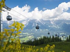
Gruttenhütte via Klammlweg
The most adventurous route to the highest hut on the Wilder Kaiser.
Wochenbrunner Alm, Ellmau (1,085 m)
Hiking
Intermediate
3:15 h
5,5 km
550 Elevation gain
We are sorry, your requested page is not available. You can start a new search on this page!
The most adventurous route to the highest hut on the Wilder Kaiser.
Wochenbrunner Alm, Ellmau (1,085 m)
Hiking
Intermediate
3:15 h
5,5 km
550 Elevation gain
Shady hike with idyllic resting places and views from the Zillertaler Alpen to the Inn valley.
Hiking starting point Alpenschlössl, Söll (762 m)
Hiking
Easy
3:30 h
9,5 km
480 Elevation gain
An extensive exploration of the “Moor & more”. Exciting puzzle tour with Rocky through the Kaiserwald forest is sure to be lots of fun, even for older children.
Hiking starting point Hüttling, Going (820 m)
Hiking
Easy
3:00 h
8,0 km
380 Elevation gain
A picturesque mountain hike that leads from the turquoise waters of the most beautiful mountain lake in Tirol up to the rustic Alpine village.
Hiking starting point Seestüberl, Scheffau (890 m)
Hiking
Intermediate
3:15 h
9,3 km
360 Elevation gain
A circular route full of experiences that leads from the Seebachgraben gorge to the Wilder-Kaiser-Steig trail - discover one of the most beautiful parts of Scheffau!
Hiking starting point Tourist Info, Scheffau (738 m)
Hiking
Intermediate
7:00 h
19,6 km
1140 Elevation gain
Varied and challenging loop over the Scheffauer summit.
Kaindlhütte, Scheffau (1,293 m)
Scheffauer (2,111 m)
Hiking
Difficult
8:30 h
13,0 km
1400 Elevation gain
Round tour through Scheffau with panoramic views, refreshment by the stream and slowing down in the forest.
Hiking starting point Tourist Info, Scheffau (738 m)
Hiking
Easy
1:15 h
4,3 km
90 Elevation gain
Hike to the Gruttenhütte with great views to the Ellmauer Halt and the entire region.
Hiking starting point Tourist Info, Scheffau (738 m)
Gruttenhütte, Ellmau (1,620 m)
Hiking
Intermediate
6:30 h
16,4 km
990 Elevation gain
Circuit tour with breathtaking panorama
Astberg Bergstation
Astberg Bergstation
Hiking
Easy
1:20 h
4,1 km
140 Elevation gain
Number of rope lengths9
Access time2,0
Alpine climbing route
Multi-rope length difficulty levels5
There are 3 steep rises which are moderable with e-bikes.
Cable car valley station, Söll (725 m)
Au Hoch-Alm, Söll (1.600 m)
Cycling
Intermediate
8,9 km
860 Elevation gain
Going, Hüttling – Graspoint-Niederalm – Obere Regalm – Brennender Palven – Gaudeamushütte – Klamml – Gruttenhütte
Hiking starting point Hüttling, Going (820 m)
Gaudeamushütte, Going (1,263 m) / Gruttenhütte, Ellmau (1,620 m)
Hiking
Intermediate
4:30 h
8,0 km
1120 Elevation gain
Through the winter forest to the wildlife park at the Wochenbrunner Alm.
Hiking starting point Tourist Info, Ellmau (800 m)
Hiking
3:30 h
9,0 km
300 Elevation gain
Across snow-covered meadows along the Going 'sunny side' (Sonnseite).
Bathing lake, Going (742 m)
Hiking
1:30 h
3,9 km
60 Elevation gain
More than 190 sport climbing routes, difficulty levels 3 to 9a+
Route number191
Access time0,6666666666666666
Sport climbing
A beautiful easy hike at the foot of the Wilder Kaiser
Hiking starting point Tourist Info, Ellmau (800 m)
Hiking
Easy
1:45 h
5,9 km
60 Elevation gain
Cozy winter tour in Hochsöll with lift support, refreshments and view to the Hohe Salve.
Mountain station gondola Hexenwasser, Söll (1,150 m)
Hiking
1:30 h
3,2 km
100 Elevation gain
Short hike to the waterfall in the Breuergraben along the Schwarzache.
Brandstadlbahn valley station, Scheffau (681 m)
Hiking
Easy
1:00 h
3,0 km
150 Elevation gain
A demanding mountain tour with some ferrata passages up to the highest summit in the Wilder Kaiser (2,344 m).
Hiking starting point Wochenbrunner Alm, Ellmau (1,085 m)
Hiking
Difficult
7:30 h
9,3 km
1250 Elevation gain
The panoramic Scheffauer is the last high peak in the west at 2,111 m above sea level.
Hiking starting point Bärnstatt, Scheffau (920 m)
Hiking
Difficult
7:00 h
7,9 km
1180 Elevation gain
Picturesque circular hiking trail on the sunny side of Going in unspoilt nature - over snow fields with fantastic views of Going aht the Wilder Kaiser.
Hiking starting point Going center (former tourist information Going) (764 m)
Hiking
1:45 h
4,8 km
80 Elevation gain
Sports ground, Söll (687 m)
Jogging
Easy
8,0 km
100 Elevation gain
Pull on your walking boots and join us on a hike across Tirol! The first stage of the Eagle Walk provides a truly spectacular start to what is set to be an unforgettable journey from east to west. We begin our adventure in the Kaiser Mountains with their craggy grey peaks towering above lush green meadows. Some of the most famous mountains in this part of Tirol include the Maukspitze, Ackerlspitze, Regalpspitze and Törlspitze, all of which are over 2,000 metres high. The hike begins at the Gasthaus Rummlerhof, a guesthouse to the north-west of the centre of St. Johann. Upon arrival at your destination, the Gaudeamushütte, you can raise your glass and to a successful day and sing: "Gaudeamus igitur - Let us be happy!". Alternatively, why not add an extra challenge and take on the 400 vertical metres up to the Gruttenhütte?
Rummlerhof, St.Johann in Tirol
Gaudeamushütte
Hiking
Intermediate
5:00 h
13,0 km
1060 Elevation gain
Along the Going Sonnseite where you can breathe in fresh winter air.
Bathing lake, Going (742 m)
Cross-country skiing
Intermediate
7,7 km
110 Elevation gain
A must for hikers in Söll - local history and culinary delights on the sunny side.
Hiking starting point Franzlhof, Söll (703 m)
Hiking
Intermediate
3:45 h
11,0 km
420 Elevation gain
Bike to the Hexenwasser theme park and Hochsöll.
Village Center, Söll (689 m)
Hexenwasser theme park, Hochsöll (1,150 m)
Cycling
Intermediate
5,1 km
480 Elevation gain
Looping the village of Söll, the sight seeing hike!
Hiking starting point Tourist Info, Söll (689 m)
Hiking
Easy
1:00 h
3,7 km
50 Elevation gain
Enjoy unspoilt views of the Sölllandl region from snow-covered fields.
Hiking starting point Franzlhof, Söll (703 m)
Hiking
2:15 h
5,8 km
100 Elevation gain
Winter hike with picturesque views of the Wilder Kaiser to the 'Wolfsegg' plateau
Hiking starting point Going center (former tourist information Going) (764 m)
Hiking
1:30 h
4,0 km
65 Elevation gain
With the Söller Zehner (1st competition in the Tour de Tirol) the circuit is run three times!
Hiking starting point Tourist Info, Söll (689 m)
Jogging
Easy
3,3 km
80 Elevation gain
Off the beaten track up to the Köpfing farmhouse. “Der Bergdoktor” (The Mountain Doctor) is a famous German-Austrian TV series, which is produced in the Wilder Kaiser region.
Bergdoktor parking lot, Söll
Hiking
Easy
3:00 h
8,4 km
370 Elevation gain
Ellmau Tourist Information Office - golf course - Wochenbrunner Alm
Tourist Information Office, Ellmau (800 m)
Wochenbrunner Alm, Ellmau (1,085 m)
Cycling
Intermediate
4,8 km
260 Elevation gain
Themed hiking route with a trail full of natural experiences alongside the refreshing water.
Hiking starting point Tourist Info, Scheffau (738 m)
Hiking
Intermediate
2:30 h
7,2 km
300 Elevation gain
Is it about the journey or the destination? Well, one of the destinations of this stage is definitely the Hintersteiner See lake and its views. Surrounded by stunning mountain vistas, dwarf pine scrubland and beech forests, the lake is one of the cleanest and most beautiful mountain lakes in Tirol. The private pristine gem covers 56 hectares and measures 36 metres at its deepest point. With this picture-perfect backdrop, hikers will complete the remaining distance to the Kaindlhütte hut in no time.
Gaudeamushütte
Hintersteiner See
Hiking
Intermediate
6:30 h
15,1 km
888 Elevation gain
This is a very well secured sport climbing route in excellent rock conditions.
Number of rope lengths10
Access time2,0
Alpine climbing route
Multi-rope length difficulty levels8+
Bike tour to the idyllically situated Obere Regalm with a magnificent view.
Tourist Info, Going (764 m)
Cycling
Intermediate
7,3 km
580 Elevation gain
Ideal circuit for beginners to start exercising
Tourist Information Office, Going (766 m)
Jogging
Easy
0:20 h
3,1 km
75 Elevation gain
Number of rope lengths8
Access time2,0
Alpine climbing route
Multi-rope length difficulty levels8-
34 magnificent routes with a fantastic panoramic view of the summits.
Route number34
Access time1,5
Sport climbing
Peace and strength, slow down and take a deep breath.
Ahornsee car park, Söll (693 m)
Hiking
4:45 h
12,0 km
220 Elevation gain