


 Deutsch
 Nederlands
Connection Blattlloipe-Aschauerloipe

Cross-country skiing
Easy
1,0 km
We are sorry, your requested page is not available. You can start a new search on this page!
Cross-country skiing
Easy
1,0 km

Approaching from the north, this trail leads through the Steinerne Rinne to the majestic Ellmauer Tor.
Griesner Alm, 988 m
Wochenbrunner Alm, Ellmau (1,085 m)
Hiking
Difficult
5:45 h
8,1 km
1060 Elevation gain

Ellmau hiking info point - Gasthof Au - Ellmauer Hof - Haflingertränke - Auwald - Ellmau hiking info point
Hiking starting point Tourist Info, Ellmau (800 m)
Hiking starting point Tourist Info, Ellmau (800 m)
Jogging
Easy
1:30 h
9,8 km
300 Elevation gain

Atmospheric forest walk along the snow-white creek.
Hiking starting point Tourist Info, Scheffau (738 m)
Hiking starting point Tourist Info, Scheffau (738 m)
Hiking
Intermediate
2:00 h
4,2 km
160 Elevation gain

More than 190 sport climbing routes, difficulty levels 3 to 9a+
Route number191
Access time0,6666666666666666
Sport climbing

Pure adrenaline is the motto of the Pölven trail on the third day of the Tour de Tirol
Hiking starting point Tourist Info, Söll (689 m)
Hiking starting point Tourist Info, Söll (689 m)
Jogging
Intermediate
24,2 km
1260 Elevation gain

This pleasant circular walk takes you to Söll’s war memorial in a beautiful section of forest.
Hiking starting point Tourist Info, Söll (689 m)
Hiking starting point Tourist Info, Söll (689 m)
Hiking
Easy
0:30 h
2,1 km
10 Elevation gain

Access time0,75
Via ferrata
Difficulty levelB-C
Via ferrara length200,0 m

Sunny walk over snowfields with enchanting landscape. An easy and enjoyable circuit in Going for the whole family.
Hiking starting point Going center (former tourist information Going) (764 m)
Hiking starting point Going center (former tourist information Going) (764 m)
Hiking
Easy
3:00 h
7,9 km
80 Elevation gain

A moderately challenging panoramic circuit around the Astberg mountain.
Tourist Info, Going (764 m)
Tourist Info, Going (764 m)
Cycling
Intermediate
15,3 km
480 Elevation gain

Explore the sunny foot of the Pölven mountain.
Cross-country skiing
Easy
0,9 km

Scenic and varied circular hike.
Hiking starting point Going center (former tourist information Going) (764 m)
Hiking starting point Going center (former tourist information Going) (764 m)
Hiking
Intermediate
4:00 h
11,0 km
500 Elevation gain

Number of rope lengths3
Access time2,0
Alpine climbing route
Multi-rope length difficulty levels7-

From Going to the Astberg with a small altitude loop & impressive panoramic view.
Hiking starting point Going center (former tourist information Going) (764 m)
Hiking starting point Going center (former tourist information Going) (764 m)
Hiking
Easy
3:30 h
8,6 km
560 Elevation gain

Calling bike fans of all ability levels! The Kaiser circular cycling route is an 80-kilometre bike route through the spectacular scenery of the Kaisergebirge mountain range. An excellent network of well-signposted trails (a mix of asphalt and gravel paths) leads past idyllic nature, breathtaking panoramas and cultural sights. For relaxing moments in between stages, cool lakes and local restaurants invite you to linger and enjoy.
anywhere along the tour
anywhere along the tour
Cycling
Intermediate
83,0 km
700 Elevation gain

A demanding mountain tour with some ferrata passages up to the highest summit in the Wilder Kaiser (2,344 m).
Hiking starting point Wochenbrunner Alm, Ellmau (1,085 m)
Hiking starting point Wochenbrunner Alm, Ellmau (1,085 m)
Hiking
Difficult
7:30 h
9,3 km
1250 Elevation gain

Enjoy the scenic area of the Hohe Salve where the Söll waters originate.
Exit Keat chairlift, Söll (1,533 m)
Exit Keat chairlift, Söll (1,533 m)
Hiking
Intermediate
3:45 h
10,3 km
530 Elevation gain

This familyfriendly hike leads you along the panoramic trail from the Brandstadl mountain in Scheffau to the Hartkaiser mountain in Ellmau.
Brandstadlbahn mountain station, Scheffau (1,650 m) or Hartkaiserbahn mountain station, Ellmau (1.550 m)
Brandstadlbahn mountain station, Scheffau (1,650 m) or Hartkaiserbahn mountain station, Ellmau (1.550 m)
Hiking
Easy
1:50 h
6,0 km
170 Elevation gain

A tour for experienced bikers in the Kaiser's Alpine pasture area.
Community Hall, Scheffau (740 m)
Community Hall, Scheffau (740 m)
Cycling
Difficult
21,3 km
690 Elevation gain

This is a very well secured sport climbing route in excellent rock conditions.
Number of rope lengths10
Access time2,0
Alpine climbing route
Multi-rope length difficulty levels8+

Number of rope lengths12
Access time2,0
Alpine climbing route
Multi-rope length difficulty levels3+

Round tour through Scheffau with vitalising stations for refreshment and relaxation.
Hiking starting point Tourist Info, Scheffau (738 m)
Hiking starting point Tourist Info, Scheffau (738 m)
Hiking
Easy
1:15 h
4,3 km
90 Elevation gain
Hikers exploring Tirol on foot will feel as free as a bird. The eagle walk is one of the 'Great Walks' of Tyrol chosen by a jury. They offer hikers the chance to get away from it all, discover the beauty of nature and experience a true adventure in the Alps.
St. Johann in Tirol
Arlbergpass
Hiking
Difficult
413,0 km
31000 Elevation gain

Over snow-covered meadows along the Goinger Sonnseite
Bathing lake, Going (742 m)
Bathing lake, Going (742 m)
Hiking
Easy
1:30 h
3,9 km
60 Elevation gain

A tour of the main filming locations of the TV series “Der Bergdoktor” (The Mountain Doctor) in Ellmau, with a refreshment stop at the inn used during filming
Hiking starting point Tourist Info, Ellmau (798 m)
Hiking starting point Tourist Info, Ellmau (798 m)
Hiking
Easy
2:15 h
7,5 km
200 Elevation gain

Access time2,0
Via ferrata
Difficulty levelB-C
Via ferrara length200,0 m

Going, Hüttling - Schleierwasserfall - Obere Regalm - Baumgartenköpfl (Bergsteigergrab) - Gaudeamushütte - Ellmauer Tor - Hintere Goinger Halt - Jubiläumssteig - Gruttenhütte - Kaiser-Hochalm - Steiner-Hochalm - Hinterschießling Alm - Rehbachklamm - Scheffau, Dorf
Hiking starting point Hüttling, Going (820 m)
Scheffau village (738 m)
Hiking
Difficult
14:00 h
24,6 km
2060 Elevation gain

Hiking trail no. 8 to the Hausberg via the Marienkapelle (St Mary’s Chapel)
Hiking starting point Tourist Information Office, Ellmau (798 m)
Brenner Alm, Ellmau (1,236 m)
Hiking
Easy
1:30 h
3,5 km
500 Elevation gain

This well-secured sport climbing route features interesting lines in prime rock.
Number of rope lengths9
Access time2,0
Alpine climbing route
Multi-rope length difficulty levels8+

Past inn, farm and chapel in the Kaiser countryside.
Hiking starting point Going Center (former Tourist informatin Going)
Hiking starting point Going Center (former Tourist informatin Going)
Cross-country skiing
Easy
1,2 km
10 Elevation gain

A tour of the main filming locations of the TV series “Der Bergdoktor” (The Mountain Doctor) in Ellmau and Going, with a refreshment stop at the inn used during filming
Hiking info point, Tourist Info Ellmau (800 m)
Hiking info point, Tourist Info Ellmau (800 m)
Hiking
Easy
3:15 h
11,4 km
180 Elevation gain

A circuit around the mountain that the locals love for its great view.
Hiking starting point Franzlhof, Söll (703 m)
Hiking starting point Franzlhof, Söll (703 m)
Hiking
Intermediate
6:00 h
17,8 km
670 Elevation gain

Hike from the Kaiserlift mountain station via the Kaindlhütte and Walleralm to Hintersteiner See.
Mountain station Kaiserlift, Kufstein (1256 m)
Hiking starting point Seestüberl, Scheffau (890 m)
Hiking
Intermediate
3:20 h
8,8 km
340 Elevation gain

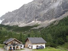
Is it about the journey or the destination? Well, one of the destinations of this stage is definitely the Hintersteiner See lake and its views. Surrounded by stunning mountain vistas, dwarf pine scrubland and beech forests, the lake is one of the cleanest and most beautiful mountain lakes in Tirol. The private pristine gem covers 56 hectares and measures 36 metres at its deepest point. With this picture-perfect backdrop, hikers will complete the remaining distance to the Kaindlhütte hut in no time.
Gaudeamushütte
Hintersteiner See
Hiking
Intermediate
6:30 h
15,1 km
888 Elevation gain

The Schattseit trail, mystical and refreshing in equal measure, is a section of the infamous Kaisermarathon, probably the toughest mountain marathon in the Alps.
Tourismus Info, Söll
Tourismus Info, Söll
Jogging
Easy
12,8 km
330 Elevation gain

Hikers, young and old alike, will find in this wild romantic gorge natural playgrounds such as bridges and balancing beams by streams and ponds.
Hiking starting point Tourist Info, Scheffau (738 m)
Hiking starting point Tourist Info, Scheffau (738 m)
Hiking
Easy
1:15 h
3,5 km
130 Elevation gain

Family roundtrip through the Rebachklamm to the Seilabodenkreuz, via the Kaiseralm and the Jägerwirt back to the center of Scheffau.
Community Hall, Scheffau (740 m)
Community Hall, Scheffau (740 m)
Hiking
Intermediate
3:15 h
9,7 km
510 Elevation gain

This 3-part Via Ferrata features a rope bridge and an extremely difficult exit option.
Via ferrata
Length160,0 m

Cross-country skiing and hiking route through a delightful winter landscape via the Auwald and Niederachen districts.
Cross-country skiing
Easy
3,6 km
10 Elevation gain

"Enjoyable" winter hike with a cozy stop and a fantastic panorama.
Hiking starting point Tourist Info, Ellmau (800 m)
Hiking starting point Tourist Info, Ellmau (800 m)
Hiking
Easy
4:30 h
10,5 km
370 Elevation gain