


 Deutsch
 Nederlands
Sonnbichl circular route

Ideal tour for starters and high temperatures.
Hiking starting point Franzlhof, Söll (703 m)
Hiking starting point Franzlhof, Söll (703 m)
Hiking
Easy
0:45 h
2,4 km
50 Elevation gain
Featuring fantastic panoramic views, experience the Wilder Kaiser region and its diverse landscape along numerous mountain trails of intermediate difficulty. Afterwards, reflect on the day’s events at rustic mountain huts offering delicious food and drink.
Featuring fantastic panoramic views, experience the Wilder Kaiser region and its diverse landscape along numerous mountain trails of intermediate difficulty. Afterwards, reflect on the day’s events at rustic mountain huts offering delicious food and drink.
Ideal tour for starters and high temperatures.
Hiking starting point Franzlhof, Söll (703 m)
Hiking starting point Franzlhof, Söll (703 m)
Hiking
Easy
0:45 h
2,4 km
50 Elevation gain
 Closed
Moderately difficult ascent route along the ski route 80c/d to the Hartkaiser.
Hartkaiserbahn valley station, Ellmau (824 m)
Hartkaiserbahn mountain station, Ellmau (1.524 m)
Ski tour
Intermediate
2:30 h
4,2 km
700 Elevation gain

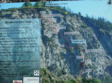
60-metre high rock dome – the Mecca for extreme climbers
Route number226
Access time1:15 h
Sport climbing

The Hintere Goinger Halt (2,193 m) is considered to be the easiest summit to reach in the Wilder Kaiser.
Hiking starting point Wochenbrunner Alm, Ellmau (1,085 m)
Hiking starting point Wochenbrunner Alm, Ellmau (1,085 m)
Hiking
Difficult
6:30 h
8,9 km
1090 Elevation gain

Varied round tour with many refreshments and wonderful views
Tourist Information Office, Scheffau (737 m)
Tourist Information Office, Scheffau (737 m)
Cycling
Intermediate
23,6 km
660 Elevation gain

Bike tour of medium difficulty between Hexenwasser theme park and Filzalmsee.
Tourist Information Office, Söll (703 m)
Filzalmsee
Cycling
Intermediate
8,8 km
680 Elevation gain

Explore small places with farms, forests and views of the valley between Scheffau and Ellmau.
Hiking starting point Tourist Info, Scheffau (737 m)
Hiking starting point Tourist Info, Scheffau (737 m)
Hiking
Easy
2:45 h
8,5 km
270 Elevation gain
 Partially open
Themed hiking route with a trail full of natural experiences alongside the refreshing water.
Hiking starting point Tourist Info, Scheffau (738 m)
Hiking starting point Tourist Info, Scheffau (738 m)
Hiking
Intermediate
2:30 h
7,2 km
300 Elevation gain

This pleasant circular walk takes you to Söll’s war memorial in a beautiful section of forest.
Hiking starting point Tourist Info, Söll (689 m)
Hiking starting point Tourist Info, Söll (689 m)
Hiking
Easy
0:30 h
2,1 km
10 Elevation gain

The largest bouldering hall in the Tirolean Unterland region.
Climbing room
Via ferrata

The highlight for everyone who loves hiking for pleasure - lush Alpine meadows, sparkling mountain lakes and delightful food in the Kitzbühel Alps. And the Bergbahnen Wilder Kaiser - Brixental summer cable cars make the ascent and descent easy.
Astberg, Going
Hochsöll
Hiking
Easy
6:45 h
20,0 km
720 Elevation gain

Strength is born of calmness – and the summit cross of the Brandstadl is no exception
Cable car valley station, Söll (725 m)
Cable car valley station, Söll (725 m)
Hiking
Intermediate
3:00 h
5,6 km
910 Elevation gain

Short hike from Jägerwirt to the Kaiseralm with great mountain views.
Hiking starting point Jägerwirt, Scheffau (883 m)
Hiking starting point Jägerwirt, Scheffau (883 m)
Hiking
Easy
1:45 h
5,0 km
250 Elevation gain

Intermediate circular hike with breathtaking views on the surrounding mountains. Attention: Trail no 828 is closed due to danger of falling rocks. Detour via path no. 816 and 827 via the Obere Regalm to the Baumgartenköpfl.
Hiking starting point Tannbichl, Going (857 m)
Hiking starting point Tannbichl, Going (857 m)
Hiking
Intermediate
4:45 h
9,8 km
760 Elevation gain

On the north side up to the Ellmauer Halt summit 2,344 m.
Access time4:30 h
Via ferrata
Difficulty levelB-C
Via ferrara length2000,0 m

Going, Hüttling - Schleierwasserfall - Obere Regalm - Baumgartenköpfl (Bergsteigergrab) - Gaudeamushütte - Ellmauer Tor - Hintere Goinger Halt - Jubiläumssteig - Gruttenhütte - Kaiser-Hochalm - Steiner-Hochalm - Hinterschießling Alm - Rehbachklamm - Scheffau, Dorf
Hiking starting point Hüttling, Going (820 m)
Scheffau village (738 m)
Hiking
Difficult
14:00 h
24,6 km
2060 Elevation gain

Number of rope lengths5
Access time2:00 h
Alpine climbing route
Multi-rope length difficulty levels7+

Enjoy unspoilt views of the Sölllandl region from snow-covered fields.
Hiking starting point Franzlhof, Söll (703 m)
Hiking starting point Franzlhof, Söll (703 m)
Hiking
2:15 h
5,8 km
100 Elevation gain

Alpine pasture circular hiking route with a breathtaking view over Scheffau!
Hiking starting point Tourist Info, Scheffau (738 m)
Hiking starting point Tourist Info, Scheffau (738 m)
Hiking
Intermediate
5:15 h
12,9 km
800 Elevation gain

Stripsenjochhaus - Griesner Alm - Griesenau
Stripsenjochhaus (1,577 m)
Griesenau, Kirchdorf (719 m)
Hiking
Intermediate
3:00 h
7,9 km

A demanding mountain tour with some ferrata passages up to the highest summit in the Wilder Kaiser (2,344 m).
Hiking starting point Wochenbrunner Alm, Ellmau (1,085 m)
Hiking starting point Wochenbrunner Alm, Ellmau (1,085 m)
Hiking
Difficult
7:30 h
9,3 km
1250 Elevation gain

Savour the wonder of the winter landscape – experience the winter magic for yourself by crunching through the pristine snow with your snowshoes. Enjoy unique impressions and experiences as you explore the white winter splendour and take in the spectacular view over the surrounding mountain scenery.
Church square, Going (769 m)
Church square, Going (769 m)
Hiking
1:30 h
2,9 km
110 Elevation gain

Baumgartenköpfl (Bergsteigergrab) – Wilder-Kaiser-Steig – Jubiläumssteig – Gruttenhütte
Brennender Palven (1,572 m)
Gruttenhütte, Ellmau (1,620 m)
Hiking
Difficult
2:30 h
3,3 km
410 Elevation gain
 Closed
Access time0:45 h
Via ferrata
Difficulty levelB-C
Via ferrara length200,0 m

With the Söller Zehner (1st competition in the Tour de Tirol) the circuit is run three times!
Hiking starting point Tourist Info, Söll (689 m)
Hiking starting point Tourist Info, Söll (689 m)
Jogging
Easy
3,3 km
80 Elevation gain

Ellmau village park - Hartkaiserbahn valley station - Bergschenke - Rübezahlalm - Jägerhütte - Hartkaiser summit station
Hiking starting point Tourist Info, Ellmau (800 m)
Hartkaiser summit station, Ellmau (1,555 m)
Jogging
Intermediate
8,2 km
720 Elevation gain
Hikers exploring Tirol on foot will feel as free as a bird. The eagle walk is one of the 'Great Walks' of Tyrol chosen by a jury. They offer hikers the chance to get away from it all, discover the beauty of nature and experience a true adventure in the Alps.
St. Johann in Tirol
Arlbergpass
Hiking
Difficult
426,0 km
30000 Elevation gain

A circular route full of experiences that leads from the Seebachgraben gorge to the Wilder-Kaiser-Steig trail - discover one of the most beautiful parts of Scheffau!
Hiking starting point Tourist Info, Scheffau (738 m)
Hiking starting point Tourist Info, Scheffau (738 m)
Hiking
Intermediate
7:00 h
19,6 km
1140 Elevation gain

The viewpoint mountain of the locals, steep and fascinating.
Hiking starting point Alpenschlössl, Söll (762 m)
Hiking starting point Alpenschlössl, Söll (762 m)
Hiking
Intermediate
5:00 h
10,4 km
790 Elevation gain

Snowshoe hike via the Kaiseralmen with starting and finishing at the Gasthof Jägerwirt.
Gasthof Jägerwirt, Scheffau (883 m)
Gasthof Jägerwirt, Scheffau (883 m)
Hiking
3:15 h
4,8 km
250 Elevation gain

A tour for experienced bikers in the Kaiser's Alpine pasture area.
Community Hall, Scheffau (740 m)
Community Hall, Scheffau (740 m)
Cycling
Difficult
21,3 km
690 Elevation gain

A roundhike with family-picnic in a meadow. Tip: bring a pair of binoculars to see the chamois on the rocks.
Hiking starting point Jägerwirt, Scheffau (883 m)
Hiking starting point Jägerwirt, Scheffau (883 m)
Hiking
Intermediate
2:00 h
5,1 km
350 Elevation gain

A varied circular cycling route around hohe Salve mountain with plenty of refreshment stops.
anywhere along the tour
anywhere along the tour
Cycling
Intermediate
62,0 km
650 Elevation gain

Short, crisp connection between the Blattlloipe and the Schwendterloipe.
Cross-country skiing
Intermediate
0,5 km
30 Elevation gain

Number of rope lengths11
Access time1:30 h
Alpine climbing route
Multi-rope length difficulty levels8

Leisurely hike through forest and across meadows to the sunny plateau of Going and back
Hiking starting point Going center (former tourist information Going) (764 m)
Hiking starting point Going center (former tourist information Going) (764 m)
Hiking
Easy
1:15 h
4,1 km
70 Elevation gain

Off the beaten track up to the Köpfing farmhouse. “Der Bergdoktor” (The Mountain Doctor) is a famous German-Austrian TV series, which is produced in the Wilder Kaiser region.
Bergdoktor parking lot, Söll
Bergdoktor parking lot, Söll
Hiking
Easy
3:00 h
8,4 km
370 Elevation gain

The Kaiserkrone Trail is a trail running event with several competitions that lead around the Wilder Kaiser mountain massif. More about the event at: www.kaiserkrone.run
Start & Finish - village center of Scheffau (732 m), address: Dorf 45, 6351 Scheffau
Start & Finish - village center of Scheffau (732 m), address: Dorf 45, 6351 Scheffau
Jogging
Intermediate
20,7 km
1290 Elevation gain

A winter hiking route connects the villages of Söll and Scheffau.
Hiking starting point Tourist Info, Scheffau (737 m)
Hiking starting point Tourist Info, Söll (689 m)
Hiking
2:45 h
7,1 km
70 Elevation gain
Featuring fantastic panoramic views, experience the Wilder Kaiser region and its diverse landscape along numerous mountain trails of intermediate difficulty. Afterwards, reflect on the day’s events at rustic mountain huts offering delicious food and drink.
Ideal tour for starters and high temperatures.
Hiking starting point Franzlhof, Söll (703 m)
Hiking starting point Franzlhof, Söll (703 m)
Hiking
Easy
0:45 h
2,4 km
50 Elevation gain
ClosedModerately difficult ascent route along the ski route 80c/d to the Hartkaiser.
Hartkaiserbahn valley station, Ellmau (824 m)
Hartkaiserbahn mountain station, Ellmau (1.524 m)
Ski tour
Intermediate
2:30 h
4,2 km
700 Elevation gain
60-metre high rock dome – the Mecca for extreme climbers
Route number226
Access time1:15 h
Sport climbing
The Hintere Goinger Halt (2,193 m) is considered to be the easiest summit to reach in the Wilder Kaiser.
Hiking starting point Wochenbrunner Alm, Ellmau (1,085 m)
Hiking starting point Wochenbrunner Alm, Ellmau (1,085 m)
Hiking
Difficult
6:30 h
8,9 km
1090 Elevation gain
Varied round tour with many refreshments and wonderful views
Tourist Information Office, Scheffau (737 m)
Tourist Information Office, Scheffau (737 m)
Cycling
Intermediate
23,6 km
660 Elevation gain
Bike tour of medium difficulty between Hexenwasser theme park and Filzalmsee.
Tourist Information Office, Söll (703 m)
Filzalmsee
Cycling
Intermediate
8,8 km
680 Elevation gain
Explore small places with farms, forests and views of the valley between Scheffau and Ellmau.
Hiking starting point Tourist Info, Scheffau (737 m)
Hiking starting point Tourist Info, Scheffau (737 m)
Hiking
Easy
2:45 h
8,5 km
270 Elevation gain
Partially openThemed hiking route with a trail full of natural experiences alongside the refreshing water.
Hiking starting point Tourist Info, Scheffau (738 m)
Hiking starting point Tourist Info, Scheffau (738 m)
Hiking
Intermediate
2:30 h
7,2 km
300 Elevation gain
This pleasant circular walk takes you to Söll’s war memorial in a beautiful section of forest.
Hiking starting point Tourist Info, Söll (689 m)
Hiking starting point Tourist Info, Söll (689 m)
Hiking
Easy
0:30 h
2,1 km
10 Elevation gain
The largest bouldering hall in the Tirolean Unterland region.
Climbing room
Via ferrata
The highlight for everyone who loves hiking for pleasure - lush Alpine meadows, sparkling mountain lakes and delightful food in the Kitzbühel Alps. And the Bergbahnen Wilder Kaiser - Brixental summer cable cars make the ascent and descent easy.
Astberg, Going
Hochsöll
Hiking
Easy
6:45 h
20,0 km
720 Elevation gain
Strength is born of calmness – and the summit cross of the Brandstadl is no exception
Cable car valley station, Söll (725 m)
Cable car valley station, Söll (725 m)
Hiking
Intermediate
3:00 h
5,6 km
910 Elevation gain
Short hike from Jägerwirt to the Kaiseralm with great mountain views.
Hiking starting point Jägerwirt, Scheffau (883 m)
Hiking starting point Jägerwirt, Scheffau (883 m)
Hiking
Easy
1:45 h
5,0 km
250 Elevation gain
Intermediate circular hike with breathtaking views on the surrounding mountains. Attention: Trail no 828 is closed due to danger of falling rocks. Detour via path no. 816 and 827 via the Obere Regalm to the Baumgartenköpfl.
Hiking starting point Tannbichl, Going (857 m)
Hiking starting point Tannbichl, Going (857 m)
Hiking
Intermediate
4:45 h
9,8 km
760 Elevation gain
On the north side up to the Ellmauer Halt summit 2,344 m.
Access time4:30 h
Via ferrata
Difficulty levelB-C
Via ferrara length2000,0 m
Going, Hüttling - Schleierwasserfall - Obere Regalm - Baumgartenköpfl (Bergsteigergrab) - Gaudeamushütte - Ellmauer Tor - Hintere Goinger Halt - Jubiläumssteig - Gruttenhütte - Kaiser-Hochalm - Steiner-Hochalm - Hinterschießling Alm - Rehbachklamm - Scheffau, Dorf
Hiking starting point Hüttling, Going (820 m)
Scheffau village (738 m)
Hiking
Difficult
14:00 h
24,6 km
2060 Elevation gain
Number of rope lengths5
Access time2:00 h
Alpine climbing route
Multi-rope length difficulty levels7+
Enjoy unspoilt views of the Sölllandl region from snow-covered fields.
Hiking starting point Franzlhof, Söll (703 m)
Hiking starting point Franzlhof, Söll (703 m)
Hiking
2:15 h
5,8 km
100 Elevation gain
Alpine pasture circular hiking route with a breathtaking view over Scheffau!
Hiking starting point Tourist Info, Scheffau (738 m)
Hiking starting point Tourist Info, Scheffau (738 m)
Hiking
Intermediate
5:15 h
12,9 km
800 Elevation gain
Stripsenjochhaus - Griesner Alm - Griesenau
Stripsenjochhaus (1,577 m)
Griesenau, Kirchdorf (719 m)
Hiking
Intermediate
3:00 h
7,9 km
A demanding mountain tour with some ferrata passages up to the highest summit in the Wilder Kaiser (2,344 m).
Hiking starting point Wochenbrunner Alm, Ellmau (1,085 m)
Hiking starting point Wochenbrunner Alm, Ellmau (1,085 m)
Hiking
Difficult
7:30 h
9,3 km
1250 Elevation gain
Savour the wonder of the winter landscape – experience the winter magic for yourself by crunching through the pristine snow with your snowshoes. Enjoy unique impressions and experiences as you explore the white winter splendour and take in the spectacular view over the surrounding mountain scenery.
Church square, Going (769 m)
Church square, Going (769 m)
Hiking
1:30 h
2,9 km
110 Elevation gain
Baumgartenköpfl (Bergsteigergrab) – Wilder-Kaiser-Steig – Jubiläumssteig – Gruttenhütte
Brennender Palven (1,572 m)
Gruttenhütte, Ellmau (1,620 m)
Hiking
Difficult
2:30 h
3,3 km
410 Elevation gain
ClosedAccess time0:45 h
Via ferrata
Difficulty levelB-C
Via ferrara length200,0 m
With the Söller Zehner (1st competition in the Tour de Tirol) the circuit is run three times!
Hiking starting point Tourist Info, Söll (689 m)
Hiking starting point Tourist Info, Söll (689 m)
Jogging
Easy
3,3 km
80 Elevation gain
Ellmau village park - Hartkaiserbahn valley station - Bergschenke - Rübezahlalm - Jägerhütte - Hartkaiser summit station
Hiking starting point Tourist Info, Ellmau (800 m)
Hartkaiser summit station, Ellmau (1,555 m)
Jogging
Intermediate
8,2 km
720 Elevation gain
Hikers exploring Tirol on foot will feel as free as a bird. The eagle walk is one of the 'Great Walks' of Tyrol chosen by a jury. They offer hikers the chance to get away from it all, discover the beauty of nature and experience a true adventure in the Alps.
St. Johann in Tirol
Arlbergpass
Hiking
Difficult
426,0 km
30000 Elevation gain
A circular route full of experiences that leads from the Seebachgraben gorge to the Wilder-Kaiser-Steig trail - discover one of the most beautiful parts of Scheffau!
Hiking starting point Tourist Info, Scheffau (738 m)
Hiking starting point Tourist Info, Scheffau (738 m)
Hiking
Intermediate
7:00 h
19,6 km
1140 Elevation gain
The viewpoint mountain of the locals, steep and fascinating.
Hiking starting point Alpenschlössl, Söll (762 m)
Hiking starting point Alpenschlössl, Söll (762 m)
Hiking
Intermediate
5:00 h
10,4 km
790 Elevation gain
Snowshoe hike via the Kaiseralmen with starting and finishing at the Gasthof Jägerwirt.
Gasthof Jägerwirt, Scheffau (883 m)
Gasthof Jägerwirt, Scheffau (883 m)
Hiking
3:15 h
4,8 km
250 Elevation gain
A tour for experienced bikers in the Kaiser's Alpine pasture area.
Community Hall, Scheffau (740 m)
Community Hall, Scheffau (740 m)
Cycling
Difficult
21,3 km
690 Elevation gain
A roundhike with family-picnic in a meadow. Tip: bring a pair of binoculars to see the chamois on the rocks.
Hiking starting point Jägerwirt, Scheffau (883 m)
Hiking starting point Jägerwirt, Scheffau (883 m)
Hiking
Intermediate
2:00 h
5,1 km
350 Elevation gain
A varied circular cycling route around hohe Salve mountain with plenty of refreshment stops.
anywhere along the tour
anywhere along the tour
Cycling
Intermediate
62,0 km
650 Elevation gain
Short, crisp connection between the Blattlloipe and the Schwendterloipe.
Cross-country skiing
Intermediate
0,5 km
30 Elevation gain
Number of rope lengths11
Access time1:30 h
Alpine climbing route
Multi-rope length difficulty levels8
Leisurely hike through forest and across meadows to the sunny plateau of Going and back
Hiking starting point Going center (former tourist information Going) (764 m)
Hiking starting point Going center (former tourist information Going) (764 m)
Hiking
Easy
1:15 h
4,1 km
70 Elevation gain
Off the beaten track up to the Köpfing farmhouse. “Der Bergdoktor” (The Mountain Doctor) is a famous German-Austrian TV series, which is produced in the Wilder Kaiser region.
Bergdoktor parking lot, Söll
Bergdoktor parking lot, Söll
Hiking
Easy
3:00 h
8,4 km
370 Elevation gain
The Kaiserkrone Trail is a trail running event with several competitions that lead around the Wilder Kaiser mountain massif. More about the event at: www.kaiserkrone.run
Start & Finish - village center of Scheffau (732 m), address: Dorf 45, 6351 Scheffau
Start & Finish - village center of Scheffau (732 m), address: Dorf 45, 6351 Scheffau
Jogging
Intermediate
20,7 km
1290 Elevation gain
A winter hiking route connects the villages of Söll and Scheffau.
Hiking starting point Tourist Info, Scheffau (737 m)
Hiking starting point Tourist Info, Söll (689 m)
Hiking
2:45 h
7,1 km
70 Elevation gain