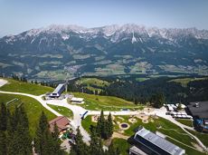
Winter hiking trails

Winter hiking trails

281 Routes and tours

Gentle snowshoe hike in the valley in Going

Gentle snowshoe hike in the valley in Going

Savour the wonder of the winter landscape – experience the winter magic for yourself by crunching through the pristine snow with your snowshoes. Enjoy unique impressions and experiences as you explore the white winter splendour and take in the spectacular view over the surrounding mountain scenery.

Church square, Going (769 m)

Church square, Going (769 m)

Hiking

1:30 h

2,9 km

110 Elevation gain

Ellmau circuit

Ellmau circuit
Ellmau circuit
Ellmau circuit

A beautiful easy hike at the foot of the Wilder Kaiser

Hiking starting point Tourist Info, Ellmau (800 m)

Hiking starting point Tourist Info, Ellmau (800 m)

Hiking

Easy

1:45 h

5,9 km

60 Elevation gain

SkiWelt Panoramic Trail

SkiWelt Panoramic Trail
SkiWelt Panoramic TrailPartially open
SkiWelt Panoramic Trail

The highlight for everyone who loves hiking for pleasure - lush Alpine meadows, sparkling mountain lakes and delightful food in the Kitzbühel Alps. And the Bergbahnen Wilder Kaiser - Brixental summer cable cars make the ascent and descent easy.

Astberg, Going

Hochsöll

Hiking

Easy

6:45 h

20,0 km

720 Elevation gain

Winter walk to Hausberg

Winter walk to Hausberg

An ascent that is rewarded with refreshments. Back to the valley with the toboggan, the lift or on foot.

Village centre, Ellmau (800 m)

Astbergbahn, Going (804 m)

Hiking

2:45 h

5,8 km

460 Elevation gain

Schiessling circuit

Schiessling circuit
Schiessling circuit
Schiessling circuit

Short tour with varied paths and views

Hiking starting point Tourismus Info, Scheffau (737 m)

Hiking starting point Tourismus Info, Scheffau (737 m)

Hiking

Easy

2:00 h

5,8 km

230 Elevation gain

Eagle Walk Tirol

Eagle Walk Tirol
Eagle Walk Tirol
Eagle Walk Tirol

Hikers exploring Tirol on foot will feel as free as a bird. The eagle walk is one of the 'Great Walks' of Tyrol chosen by a jury. They offer hikers the chance to get away from it all, discover the beauty of nature and experience a true adventure in the Alps.

St. Johann in Tirol

Arlbergpass

Hiking

Difficult

426,0 km

30000 Elevation gain

Hochlechen circular route

Hochlechen circular route

Old path - now renovated and featuring a pleasant series of ascents and descents.

Hiking starting point Bergbahn, Söll (725 m)

Hiking starting point Bergbahn, Söll (725 m)

Hiking

Intermediate

4:30 h

13,5 km

470 Elevation gain

Quellen circular route

Quellen circular route

Enjoy the scenic area of the Hohe Salve where the Söll waters originate.

Exit Keat chairlift, Söll (1,533 m)

Exit Keat chairlift, Söll (1,533 m)

Hiking

Intermediate

3:45 h

10,3 km

530 Elevation gain

Kaiser crag

Kaiser crag
Kaiser crag
Kaiser crag

Along with the Murmeltierfelsen and Gamsfelsen, there are a total of 17 climbing routes of difficulty levels 3 to 6b+ near the Gaudeamushütte mountain hut.

Route number19

Access time1,0

Sport climbing

Hartkaiserweg trail Ellmau

Hartkaiserweg trail Ellmau

Ellmau village park - Hartkaiserbahn valley station - Bergschenke - Rübezahlalm - Jägerhütte - Hartkaiser summit station

Hiking starting point Tourist Info, Ellmau (800 m)

Hartkaiser summit station, Ellmau (1,555 m)

Jogging

Intermediate

8,2 km

720 Elevation gain

Kaiser circular cycling route

Kaiser circular cycling route

Calling bike fans of all ability levels! The Kaiser circular cycling route is an 80-kilometre bike route through the spectacular scenery of the Kaisergebirge mountain range. An excellent network of well-signposted trails (a mix of asphalt and gravel paths) leads past idyllic nature, breathtaking panoramas and cultural sights. For relaxing moments in between stages, cool lakes and local restaurants invite you to linger and enjoy.

anywhere along the tour

anywhere along the tour

Cycling

Intermediate

6:45 h

85,6 km

700 Elevation gain

Hochschwendt circuit

Hochschwendt circuit

This easy family hike takes you via the Bergdoktorhaus to the Berggasthof Hochschwendt mountain inn.

Wanderstartplatz Tourist Info, Ellmau (800m)

Wanderstartplatz Tourist Info, Ellmau (800m)

Hiking

Easy

2:45 h

8,7 km

270 Elevation gain

Bergdoktor wintertour of Ellmau & Going

Bergdoktor wintertour of Ellmau & Going

A tour of the main filming locations of the TV series “Der Bergdoktor” (The Mountain Doctor) in Ellmau and Going, with a refreshment stop at the inn used during filming

Hiking starting point Tourist Info, Ellmau (800 m)

Hiking starting point Tourist Info, Ellmau (800 m)

Hiking

4:15 h

11,4 km

180 Elevation gain

Koller circular route

Koller circular route

Ancient path of the romans - a better stroll.

Hiking starting point Tourist Info, Söll (689 m)

Hiking starting point Tourist Info, Söll (689 m)

Hiking

Easy

1:00 h

3,0 km

55 Elevation gain