

Winter walking
Graspoint-Niederalm winter trail
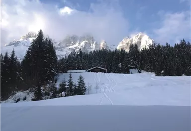
Atmospheric winter hike right into the Wilder Kaiser.
5,70 km
250 m
02:30 h
Route
5,70 km
250 m
02:30 h
981 m
Starting Point
Bathing lake, Going (742 m)
End Point
Graspoint-Niederalm, Going (981 m)
What to do in an emergency? Call emergency number
140 - Mountain Rescue (Bergrettung)
112 - European Emergency Number
133 - Police
144 - Ambulance
Many routes have rescue points at the hiking signs, which can be used as a clear location identification in an emergency.
The Alpine Club provides tips for optimal preparation for mountain hiking.
SOS-EU-Alp App
The SOS EU ALP app allows you to determine your location (x,y coordinates) via your smartphone. In an emergency, this location data can be sent directly to the responsible control center (Tyrol, South Tyrol or Bavaria).
Important Information
Our winter hiking trails across the fields are only open when there is sufficient snow.
Description
This hike starts at the bathing lake car park in Going and takes you a little way up into th emajestic Kaiser mountains. You follow the 'Aschauerweg' road which takes you above the bathing lake Going and gives you a marvellous view of Going. From here you can admire the Kitzbühler Horn.
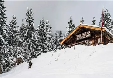
You follow the path and pass traditional, family-run farms. Turn off at the 'Moor & more' junction and continue uphill through the winter forest towards the Graspoint-Niederalm hut (not managed).
On the way, you will pass the impressive Aschinger chapel, which was built from regional fir...
Best Season
Jan
Feb
Mar
Apr
May
Jun
Jul
Aug
Sep
Oct
Nov
Dec
Skill Level
Endurance
Family-friendly
More information at: www.wilderkaiser.info/mobility
Heading from Wörgl or Kufstein on the B178 road, take the Going Prama exit before you reach the Stanglwirt hotel. When you reach the first junction, turn right in the direction of the bathing lake. Keep following the road and make another right turn towards the bathing lake after approx. 400 m. The car park is located on the right-hand side.
Camping and permanent parking is prohibited on this car park.


Current Weather
Today
2026-05-16
Morning
Afternoon
1 °C
Evening
Tomorrow
2026-05-17
Morning
1 °C
Afternoon
5 °C
Evening
4 °C
Monday
2026-05-18
Morning
6 °C
Afternoon
9 °C
Evening
5 °C
Tuesday
2026-05-19
Morning
2 °C
Afternoon
5 °C
Evening
5 °C
Wednesday
2026-05-20
Morning
5 °C
Afternoon
7 °C
Evening
7 °C
Thursday
2026-05-21
Morning
7 °C
Afternoon
10 °C
Evening
9 °C
Friday
2026-05-22
Morning
9 °C
Afternoon
13 °C
Evening
12 °C
Saturday
2026-05-23
Morning
12 °C
Afternoon
14 °C
Evening
13 °C
Sunday
2026-05-24
Morning
12 °C
Afternoon
15 °C
Evening
13 °C
Monday
2026-05-25
Morning
11 °C
Afternoon
14 °C
Evening
12 °C
Tuesday
2026-05-26
Morning
11 °C
Afternoon
14 °C
Evening
13 °C
Wednesday
2026-05-27
Morning
11 °C
Afternoon
13 °C
Evening
12 °C
Thursday
2026-05-28
Morning
10 °C
Afternoon
14 °C
Evening
12 °C
Friday
2026-05-29
Morning
11 °C
Afternoon
14 °C
Evening
12 °C
Last updated at 05/16/2026, 02:00 PM
Contact
Contact
You have questions? We are happy to assist you.


