


 Deutsch
 English
Snowcrystal circuit route

Explore the sunny foot of the Pölven mountain.
Hiking starting point Franzlhof, Söll (703 m)
Hiking starting point Franzlhof, Söll (703 m)
Wandelen
Normaal
2:30 u
6,8 km
100 Hoogtemeters
De door u opgevraagde pagina is niet beschikbaar. U bent welkom om een nieuwe zoekopdracht op deze pagina te starten.
Explore the sunny foot of the Pölven mountain.
Hiking starting point Franzlhof, Söll (703 m)
Hiking starting point Franzlhof, Söll (703 m)
Wandelen
Normaal
2:30 u
6,8 km
100 Hoogtemeters

Short circular walk at the snow-white Brandstadl mountain with panorama view.
Brandstadlbahn summit station, Scheffau (1,643 m)
Brandstadlbahn summit station, Scheffau (1,643 m)
Wandelen
Gemakkelijk
0:30 u
1,3 km
40 Hoogtemeters

Eventful hike for families with a great panoramic view and playgrounds for children.
Brandstadlbahn summit station, Scheffau (1,643 m)
Hexenwasser theme park, Söll (1,150 m)
Wandelen
Normaal
4:00 u
11,0 km
350 Hoogtemeters

More than 190 sport climbing routes, difficulty levels 3 to 9a+
Sportklimmen

This tour is rich in variety and includes slabs, water grooves, as well as a strong overhang and a traverse with an undercling passage.
Alpine klimroutes

Peace and strength, slow down and take a deep breath.
Ahornsee car park, Söll (693 m)
Ahornsee car park, Söll (693 m)
Wandelen
Normaal
4:45 u
12,0 km
220 Hoogtemeters

Approaching from the north, this trail leads through the Steinerne Rinne to the majestic Ellmauer Tor.
Griesner Alm, 988 m
Wochenbrunner Alm, Ellmau (1,085 m)
Wandelen
Moeilijk
5:45 u
8,1 km
1060 Hoogtemeters

Historical route pleasant to walk for everyone.
Hiking starting point Tourist Info, Söll (689 m)
Hiking starting point Tourist Info, Söll (689 m)
Wandelen
Gemakkelijk
1:00 u
3,0 km
40 Hoogtemeters

Dizzying experience via snack stations to the waterfall via unmanaged alpine pastures to the Hexenwasser. Return to the valley by cable car or on foot.
Hiking starting point Bergbahn, Söll (725 m)
Hiking starting point Bergbahn, Söll (725 m)
Wandelen
Normaal
2:00 u
5,6 km
500 Hoogtemeters

Bike tour of medium difficulty between Hexenwasser theme park and Filzalmsee.
Tourist Information Office, Söll (703 m)
Filzalmsee
Fietsen
Normaal
8,8 km
680 Hoogtemeters

A roundhike with family-picnic in a meadow. Tip: bring a pair of binoculars to see the chamois on the rocks.
Hiking starting point Jägerwirt, Scheffau (883 m)
Hiking starting point Jägerwirt, Scheffau (883 m)
Wandelen
Normaal
2:00 u
5,1 km
350 Hoogtemeters

Stripsenjochhaus – Eggersteig – Steinerne Rinne – Ellmauer Tor – Jubiläumssteig – Gruttenhütte
Stripsenjochhaus, St. Johann in Tirol (1,577 m)
Gaudeamushütte, Going (1,263 m)
Wandelen
Moeilijk
5:00 u
6,3 km
590 Hoogtemeters

Up for a wild witch’s ride? Day and night: off you go!
Cable car valley station, Söll (725 m)
Cable car valley station, Söll (725 m)
Rodelen
Normaal
3,0 km

A picturesque mountain hike that leads from the turquoise waters of the most beautiful mountain lake in Tirol up to the rustic Alpine village.
Hiking starting point Seestüberl, Scheffau (890 m)
Hiking starting point Seestüberl, Scheffau (890 m)
Wandelen
Normaal
3:15 u
9,3 km
360 Hoogtemeters

Gaudeamushütte - Ellmauer Tor - Klammlweg - Gruttenhütte
Gaudeamushütte, Going (1,263 m)
Gruttenhütte, Ellmau (1,620 m)
Wandelen
Normaal
4:45 u
5,9 km
990 Hoogtemeters

Calling bike fans of all ability levels! The Kaiser circular cycling route is an 80-kilometre bike route through the spectacular scenery of the Kaisergebirge mountain range. An excellent network of well-signposted trails (a mix of asphalt and gravel paths) leads past idyllic nature, breathtaking panoramas and cultural sights. For relaxing moments in between stages, cool lakes and local restaurants invite you to linger and enjoy.
anywhere along the tour
anywhere along the tour
Fietsen
Normaal
83,0 km
700 Hoogtemeters

Pure adrenaline is the motto of the Pölven trail on the third day of the Tour de Tirol
Hiking starting point Tourist Info, Söll (689 m)
Hiking starting point Tourist Info, Söll (689 m)
Hardlopen
Normaal
22,8 km
1110 Hoogtemeters

Via ferrata

Alpine klimroutes

Hike from the Kaiserlift mountain station via the Kaindlhütte and Walleralm to Hintersteiner See.
Mountain station Kaiserlift, Kufstein (1256 m)
Hiking starting point Seestüberl, Scheffau (890 m)
Wandelen
Normaal
3:20 u
8,8 km
340 Hoogtemeters

Very demanding round tour to the two eastern peaks in the Wilder Kaiser.
Hiking starting point Tannbichl, Going (857 m)
Hiking starting point Tannbichl, Going (857 m)
Wandelen
Moeilijk
9:00 u
13,0 km
1570 Hoogtemeters

This familyfriendly hike leads you along the panoramic trail from the Brandstadl mountain in Scheffau to the Hartkaiser mountain in Ellmau.
Brandstadlbahn mountain station, Scheffau (1,650 m) or Hartkaiserbahn mountain station, Ellmau (1.550 m)
Brandstadlbahn mountain station, Scheffau (1,650 m) or Hartkaiserbahn mountain station, Ellmau (1.550 m)
Wandelen
Gemakkelijk
1:50 u
6,0 km
170 Hoogtemeters

Langlaufen
Gemakkelijk
1,0 km

From Hochsöll (Hexenwasser theme park) and Filzalmsee lake to Brixen im Thale.
Hexenwasser theme park Söll Hohe Salve
Brixen im Thale valley station
Fietsen
Normaal
9,3 km
200 Hoogtemeters

Picturesque circular route on the sunny side of Going in unspoilt natural surroundings through snow-covered fields offering wonderful views of Going and the Wilder Kaiser region.
Hiking starting point Going center (former tourist information Going) (764 m)
Hiking starting point Going center (former tourist information Going) (764 m)
Wandelen
Gemakkelijk
1:45 u
4,8 km
80 Hoogtemeters

From Going to the Astberg with a small altitude loop & impressive panoramic view.
Hiking starting point Going center (former tourist information Going) (764 m)
Hiking starting point Going center (former tourist information Going) (764 m)
Wandelen
Gemakkelijk
3:30 u
8,6 km
560 Hoogtemeters

A demanding mountain tour with some ferrata passages up to the highest summit in the Wilder Kaiser (2,344 m).
Hiking starting point Wochenbrunner Alm, Ellmau (1,085 m)
Hiking starting point Wochenbrunner Alm, Ellmau (1,085 m)
Wandelen
Moeilijk
7:30 u
9,3 km
1250 Hoogtemeters

A challenging circular mountainbike tour with plenty of welcoming refreshment stops.
Village Center, Söll (703 m)
Village Center, Söll (703 m)
Fietsen
Normaal
28,5 km
950 Hoogtemeters

The largest bouldering hall in the Tirolean Unterland region.
Kletterhalle

A circular route full of experiences that leads from the Seebachgraben gorge to the Wilder-Kaiser-Steig trail - discover one of the most beautiful parts of Scheffau!
Hiking starting point Tourist Info, Scheffau (738 m)
Hiking starting point Tourist Info, Scheffau (738 m)
Wandelen
Normaal
7:00 u
19,6 km
1140 Hoogtemeters

A short winter walk on Hartkaiser hrough Ellmi's magical world.
Hiking starting point Tourist Info, Ellmau (800 m)
Hiking starting point Tourist Info, Ellmau (800 m)
Wandelen
Gemakkelijk
0:30 u
1,0 km
25 Hoogtemeters

Pleasant circular hiking trail through forests and meadows to the romantically situated moor lake.
Hiking starting point Franzlhof, Söll (703 m)
Hiking starting point Franzlhof, Söll (703 m)
Wandelen
Normaal
2:00 u
5,7 km
240 Hoogtemeters

Round tour through Scheffau with vitalising stations for refreshment and relaxation.
Hiking starting point Tourist Info, Scheffau (738 m)
Hiking starting point Tourist Info, Scheffau (738 m)
Wandelen
Gemakkelijk
1:15 u
4,3 km
90 Hoogtemeters

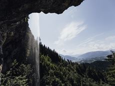
Fork 823/826 – via waterfall – Veitskirche – Steiner-Hochalm
Fork on the Wilder-Kaiser-Steig 823/826 (1,405 m)
Steiner-Hochalm, Scheffau (1,257 m)
Wandelen
Normaal
2:30 u
3,8 km
360 Hoogtemeters

Along the Going Sonnseite where you can breathe in fresh winter air.
Bathing lake, Going (742 m)
Bathing lake, Going (742 m)
Langlaufen
Normaal
7,7 km
110 Hoogtemeters
Going, Hüttling - Schleierwasserfall - Obere Regalm - Baumgartenköpfl (Bergsteigergrab) - Gaudeamushütte
Hiking starting point Hüttling, Going (820 m)
Gaudeamushütte, Going (1,263 m)
Wandelen
Normaal
4:00 u
7,3 km
860 Hoogtemeters

Comfortable round with a magnificent view of the Hohe Salve.
Mountain station gondola Hexenwasser, Söll (1,150 m)
Mountain station gondola Hexenwasser, Söll (1,150 m)
Wandelen
Gemakkelijk
0:35 u
1,8 km
50 Hoogtemeters

Alpine klimroutes

It’s up and away to a popular inn in Söll.
Hiking starting point Tourist Info, Söll (689 m)
Stallhäusl, Söll (972 m)
Fietsen
Normaal
6,1 km
310 Hoogtemeters

Ellmau village park - Hartkaiserbahn valley station - Bergschenke - Rübezahlalm - Jägerhütte - Hartkaiser summit station
Hiking starting point Tourist Info, Ellmau (800 m)
Hartkaiser summit station, Ellmau (1,555 m)
Hardlopen
Normaal
8,2 km
720 Hoogtemeters