


 Deutsch
 English
Whisky & Cigarettes route

This is a very well secured sport climbing route in excellent rock conditions.
Alpine klimroutes
De door u opgevraagde pagina is niet beschikbaar. U bent welkom om een nieuwe zoekopdracht op deze pagina te starten.
This is a very well secured sport climbing route in excellent rock conditions.
Alpine klimroutes

A running circuit from Scheffau towards Ellmau via the Auwald district.
Starting point Scheffau Tourist Information Office (752 m)
Starting point Scheffau Tourist Information Office (752 m)
Hardlopen
Gemakkelijk
7,7 km
180 Hoogtemeters

Pleasant circular hiking trail through forests and meadows to the romantically situated moor lake.
Hiking starting point Franzlhof, Söll (703 m)
Hiking starting point Franzlhof, Söll (703 m)
Wandelen
Normaal
2:00 u
5,7 km
240 Hoogtemeters
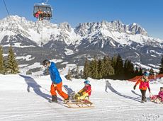
A mountain with lots of tobogganing options and good refreshment stops.
Astbergbahn Talstation, Going (805 m)
Astbergbahn Talstation, Going (805 m)
Rodelen
Normaal
3,2 km

Short hike to the waterfall in the Breuergraben along the Schwarzache.
Brandstadlbahn valley station, Scheffau (681 m)
Brandstadlbahn valley station, Scheffau (681 m)
Wandelen
Gemakkelijk
1:00 u
3,0 km
150 Hoogtemeters

Enjoy the scenic area of the Hohe Salve where the Söll waters originate.
Exit Keat chairlift, Söll (1,533 m)
Exit Keat chairlift, Söll (1,533 m)
Wandelen
Normaal
3:45 u
10,3 km
530 Hoogtemeters

Hikers, young and old alike, will find in this wild romantic gorge natural playgrounds such as bridges and balancing beams by streams and ponds.
Hiking starting point Tourist Info, Scheffau (738 m)
Hiking starting point Tourist Info, Scheffau (738 m)
Wandelen
Gemakkelijk
1:15 u
3,5 km
130 Hoogtemeters

60-metre high rock dome – the Mecca for extreme climbers
Sportklimmen

A scenic circuit past Gieringer Weiher pond, Schwarzsee lake and Going bathing lake.
Tourist Info, Going (764 m)
Tourist Info, Going (764 m)
Fietsen
Normaal
40,1 km
460 Hoogtemeters

Stripsenjochhaus - Griesner Alm - Griesenau
Stripsenjochhaus (1,577 m)
Griesenau, Kirchdorf (719 m)
Wandelen
Normaal
3:00 u
7,9 km

Pleasant hike through forests and across meadows to the sunny plateau of Going and back
Hiking starting point Going center (former tourist information Going) (764 m)
Hiking starting point Going center (former tourist information Going) (764 m)
Wandelen
Gemakkelijk
1:15 u
4,1 km
70 Hoogtemeters

Picturesque circular route on the sunny side of Going in unspoilt natural surroundings through snow-covered fields offering wonderful views of Going and the Wilder Kaiser region.
Hiking starting point Going center (former tourist information Going) (764 m)
Hiking starting point Going center (former tourist information Going) (764 m)
Wandelen
Gemakkelijk
1:45 u
4,8 km
80 Hoogtemeters

Varied and challenging loop over the Scheffauer summit.
Kaindlhütte, Scheffau (1,293 m)
Scheffauer (2,111 m)
Wandelen
Moeilijk
8:30 u
13,0 km
1400 Hoogtemeters

Wonderful winter hike on the sunny side of the valley and easy return to the starting point by bus.
Hiking starting point Tourist Information Office, Ellmau (800 m)
Hiking starting point Tourist Information Office, Scheffau (737 m)
Wandelen
Gemakkelijk
2:15 u
6,1 km
40 Hoogtemeters

mountain station Salvistabahn / Kleine Salve
Middle station Salvistabahn Itter
Wandelen
Normaal
2:45 u
7,4 km
360 Hoogtemeters

Bike to the Hexenwasser theme park and Hochsöll.
Village Center, Söll (689 m)
Hexenwasser theme park, Hochsöll (1,150 m)
Fietsen
Normaal
5,1 km
480 Hoogtemeters

Peace and strength, slow down and take a deep breath.
Ahornsee car park, Söll (693 m)
Ahornsee car park, Söll (693 m)
Wandelen
Normaal
4:45 u
12,0 km
220 Hoogtemeters

Hike from the centre of Ellmau, along trail no. 14, through the "Spatlahner gorge" up to the Wochenbrunner Alm.
Hiking starting point Tourist Information Office, Ellmau (800 m)
Hiking starting point Tourist Information Office, Ellmau (800 m)
Wandelen
Gemakkelijk
1:30 u
4,4 km
285 Hoogtemeters

Via ferrata
Comfortable winter round with a magnificent view of the Hohe Salve.
Mountain station gondola Hexenwasser, Söll (1,150 m)
Mountain station gondola Hexenwasser, Söll (1,150 m)
Wandelen
Gemakkelijk
0:45 u
1,8 km
50 Hoogtemeters

Pure adrenaline is the motto of the Pölven trail on the third day of the Tour de Tirol
Hiking starting point Tourist Info, Söll (689 m)
Hiking starting point Tourist Info, Söll (689 m)
Hardlopen
Normaal
22,8 km
1110 Hoogtemeters

Going, Hüttling - Schleierwasserfall - Obere Regalm - Baumgartenköpfl (Bergsteigergrab) - Gaudeamushütte - Ellmauer Tor - Hintere Goinger Halt - Jubiläumssteig - Gruttenhütte - Kaiser-Hochalm - Steiner-Hochalm - Hinterschießling Alm - Rehbachklamm - Scheffau, Dorf
Hiking starting point Hüttling, Going (820 m)
Scheffau village (738 m)
Wandelen
Moeilijk
14:00 u
24,6 km
2060 Hoogtemeters

Explore the sunny foot of the Pölven mountain.
Hiking starting point Franzlhof, Söll (703 m)
Hiking starting point Franzlhof, Söll (703 m)
Wandelen
Normaal
2:30 u
6,8 km
100 Hoogtemeters

Hiking trail no. 8 to the Hausberg via the Marienkapelle (St Mary’s Chapel)
Hiking starting point Tourist Information Office, Ellmau (798 m)
Brenner Alm, Ellmau (1,236 m)
Wandelen
Gemakkelijk
1:30 u
3,5 km
500 Hoogtemeters

Via ferrata
A must for hikers in Söll - local history and culinary delights on the sunny side.
Hiking starting point Franzlhof, Söll (703 m)
Hiking starting point Franzlhof, Söll (703 m)
Wandelen
Gemakkelijk
4:00 u
12,0 km
420 Hoogtemeters

Historical route pleasant to walk for everyone.
Hiking starting point Tourist Info, Söll (689 m)
Hiking starting point Tourist Info, Söll (689 m)
Wandelen
Gemakkelijk
1:00 u
3,0 km
40 Hoogtemeters

Gaudeamushütte - Ellmauer Tor - Klammlweg - Gruttenhütte
Gaudeamushütte, Going (1,263 m)
Gruttenhütte, Ellmau (1,620 m)
Wandelen
Normaal
4:45 u
5,9 km
990 Hoogtemeters

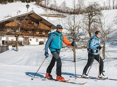
Moderately difficult ascent route along the ski route 80c/d to the Hartkaiser.
Hartkaiserbahn valley station, Ellmau (824 m)
Hartkaiserbahn mountain station, Ellmau (1.524 m)
Skitocht
Normaal
2:30 u
4,2 km
700 Hoogtemeters

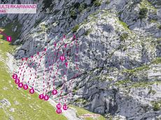
This well-secured sport climbing route features interesting lines in prime rock.
Alpine klimroutes
Easy piste tour via the family descent/moon toboggan run Route 40 (blue) to Hochsöll.
Cable Car Söll, ski touring car park
Mountain station, Hexenwasser gondola
Skitocht
Gemakkelijk
1:30 u
4,3 km
410 Hoogtemeters

Challenging adventure hike to the Ellmauer Tor
Hiking starting point Wochenbrunner Alm, Ellmau (1,085 m)
Ellmauer Tor, Ellmau (2,001 m)
Wandelen
Normaal
5:00 u
7,7 km
900 Hoogtemeters

Family-friendly, leisurely circular hike around the Astberg mountain
Astberg mountain station, Going (1.251 m)
Astberg mountain station, Going (1.251 m)
Wandelen
Gemakkelijk
0:30 u
1,5 km
80 Hoogtemeters

Short and easy circuit for beginners right next to the village of Söll.
Brunnhof field Söll
Brunnhof field Söll
Langlaufen
Gemakkelijk
0,9 km

Walk through the forest, along the river, back to the village.
Hiking starting point Tourist Info, Söll (689 m)
Hiking starting point Tourist Info, Söll (689 m)
Wandelen
Gemakkelijk
1:45 u
6,3 km
90 Hoogtemeters
31 routes, including 14 multi-pitch.
Sportklimmen

From Hochsöll (Hexenwasser theme park) and Filzalmsee lake to Brixen im Thale.
Hexenwasser theme park Söll Hohe Salve
Brixen im Thale valley station
Fietsen
Normaal
9,3 km
200 Hoogtemeters

Alpine klimroutes

Past inn, farm and chapel in the Kaiser countryside.
Hiking starting point Going Center (former Tourist informatin Going)
Hiking starting point Going Center (former Tourist informatin Going)
Langlaufen
Gemakkelijk
1,2 km
10 Hoogtemeters

Leisurely path of reflection to the St. Anna chapel at Lengau
Parkplatz Liftstation Itter (655 m)
Lengauer Kapelle
Wandelen
Gemakkelijk
1:15 u
3,2 km
270 Hoogtemeters