


 Deutsch
 English
ABS route

Beautiful, Alpine sport climbing with consistent difficulty.
Alpine klimroutes
De door u opgevraagde pagina is niet beschikbaar. U bent welkom om een nieuwe zoekopdracht op deze pagina te starten.
Beautiful, Alpine sport climbing with consistent difficulty.
Alpine klimroutes

Explore the sunny foot of the Pölven mountain.
Langlaufen
Gemakkelijk
0,9 km

Scenic and varied circular hike.
Hiking starting point Going center (former tourist information Going) (764 m)
Hiking starting point Going center (former tourist information Going) (764 m)
Wandelen
Normaal
4:00 u
11,0 km
500 Hoogtemeters

Difficult piste tour via the downhill, route no. 40a to Hochsöll Hexenwasser mountain station & further on via the Keat downhill route no. 43 to the Keat alpine pastures.
Cable Car Söll, ski touring car park
Mountain station, Hexenwasser gondola or Keat Almen
Skitocht
Moeilijk
1:30 u
4,0 km
762 Hoogtemeters

Climb to the best viewpoint in the mountains, where the Wilder Kaiser is within touching distance.
Hiking starting point Going center (former tourist information Going) (764 m)
Hiking starting point Going center (former tourist information Going) (764 m)
Wandelen
Normaal
4:30 u
10,7 km
360 Hoogtemeters

Crystal-clear mountain lake and magnificent views of the Wilder Kaiser’s western summits
Hintersteiner See, Scheffau (890 m)
Hintersteiner See, Scheffau (890 m)
Wandelen
Gemakkelijk
1:30 u
5,2 km
130 Hoogtemeters
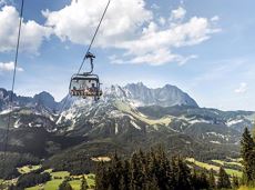
The highlight for everyone who loves hiking for pleasure - lush Alpine meadows, sparkling mountain lakes and delightful food in the Kitzbühel Alps. And the Bergbahnen Wilder Kaiser - Brixental summer cable cars make the ascent and descent easy.
Astberg, Going
Hochsöll
Wandelen
Gemakkelijk
6:45 u
20,0 km
720 Hoogtemeters

Via ferrata

An adventure hike from Ellmau village centre to the Wochenbrunner Alm mountain hut from where you can enjoy stunning views and the Ellmau Stone Circle.
Hiking starting point Tourist Info, Ellmau (800 m)
Hiking starting point Tourist Info, Ellmau (800 m)
Wandelen
Gemakkelijk
4:30 u
13,5 km
530 Hoogtemeters

The classic on the Steinplatte Waidring was rehabilitated in June 2023 and is a treat for via ferrata fans! The via ferrata "s'Schuastagangl" (C/D) offers wonderful panoramic views, crisp ascents and unforgettable mountain moments. The varied tour leads through steep rock faces and slippery passages up to the summit of the Waidringer Steinplatte (1,848m). Strength for steeper ascents and courage for ladder passages and the "Knieschloderer" variant with airy steps and a rope bridge are required!
Via ferrata

Approaching from the north, this trail leads through the Steinerne Rinne to the majestic Ellmauer Tor.
Griesner Alm, 988 m
Wochenbrunner Alm, Ellmau (1,085 m)
Wandelen
Moeilijk
5:45 u
8,1 km
1060 Hoogtemeters

This stage takes hikers to the small town of Kufstein located on the banks of the Inn river – a town which has been celebrated in song and is steeped in history and character. Walkers make their way through the lush and verdant beauty of a pasture paradise with cosy huts and mountain restaurants before stopping for a rest at the Brentenjochhütte hut (delicious “Kiachl” are served every Saturday).
Hintersteiner See
Kufstein
Wandelen
Normaal
4:00 u
12,5 km
160 Hoogtemeters

Strength is born of calmness – and the summit cross of the Brandstadl is no exception
Cable car valley station, Söll (725 m)
Cable car valley station, Söll (725 m)
Wandelen
Normaal
3:00 u
5,6 km
910 Hoogtemeters

Ellmau village park - Hartkaiserbahn valley station - Bergschenke - Rübezahlalm - Jägerhütte - Hartkaiser summit station
Hiking starting point Tourist Info, Ellmau (800 m)
Hartkaiser summit station, Ellmau (1,555 m)
Hardlopen
Normaal
8,2 km
720 Hoogtemeters
This short and easy valley circuit takes you around the village of Going am Wilden Kaiser and past the bathing lake, a delightful spot to cool off in fine weather.
Hiking starting point Going center (former tourist information Going) (764 m)
Hiking starting point Going center (former tourist information Going) (764 m)
Wandelen
Gemakkelijk
1:00 u
6,4 km
110 Hoogtemeters

By bike through the culinary region Wilder Kaiser.
anywhere along the tour
anywhere along the tour
Fietsen
Normaal
38,3 km
560 Hoogtemeters

There are 3 steep rises which are moderable with e-bikes.
Cable car valley station, Söll (725 m)
Au Hoch-Alm, Söll (1.600 m)
Fietsen
Normaal
8,9 km
860 Hoogtemeters

Culinary tour on the Hohe Salve
Bergstation Rabennest (1.150 m)
Bergstation Rabennest (1.150 m)
Wandelen
Gemakkelijk
1:30 u
4,0 km
160 Hoogtemeters

Hiking trail no. 8 to the Hausberg via the Marienkapelle (St Mary’s Chapel)
Hiking starting point Tourist Information Office, Ellmau (798 m)
Brenner Alm, Ellmau (1,236 m)
Wandelen
Gemakkelijk
1:30 u
3,5 km
500 Hoogtemeters
Hike via four mountain huts Rübezahl-Alm, Jägerhütte and Hochschwendt.
Hiking starting point Tourist Info, Ellmau (800 m)
Hiking starting point Tourist Info, Ellmau (800 m)
Wandelen
Gemakkelijk
6:15 u
14,0 km
600 Hoogtemeters

An extensive exploration of “Moor & more”. The puzzle tour in the Wilder Kaiser forest is sure to be lots of fun, even for older children.
Hiking starting point Hüttling, Going (820 m)
Hiking starting point Hüttling, Going (820 m)
Wandelen
Gemakkelijk
3:00 u
8,0 km
380 Hoogtemeters

Going, Hüttling – Graspoint-Niederalm – Obere Regalm – Brennender Palven – Gaudeamushütte – Klamml – Gruttenhütte
Hiking starting point Hüttling, Going (820 m)
Gaudeamushütte, Going (1,263 m) / Gruttenhütte, Ellmau (1,620 m)
Wandelen
Normaal
4:30 u
8,0 km
1120 Hoogtemeters

Ideal circuit for beginners to start exercising
Tourist Information Office, Going (766 m)
Tourist Information Office, Going (766 m)
Hardlopen
Gemakkelijk
0:20 u
3,1 km
75 Hoogtemeters

Via ferrata

A beautiful tour around the Kalkstein mountain and Pillersee lake.
Tourist Info, Going (764 m)
Tourist Info, Going (764 m)
Fietsen
Normaal
66,9 km
550 Hoogtemeters

Moderately difficult ascent route along the ski route 80c/d to the Hartkaiser.
Hartkaiserbahn valley station, Ellmau (824 m)
Hartkaiserbahn mountain station, Ellmau (1.524 m)
Skitocht
Normaal
2:30 u
4,2 km
700 Hoogtemeters

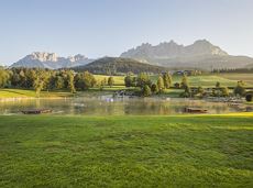
Picture-postcard panoramic scenery to Hintersteiner See lake, a natural gem.
Villag Center, Söll (689 m)
Hintersteiner See Lake, Scheffau (889 m)
Fietsen
Normaal
9,4 km
430 Hoogtemeters

Alpine klimroutes

The best seat in the house for a view of the Wilder Kaiser!
Hiking starting point Going center (former tourist information Going) (764 m)
Hiking starting point Going center (former tourist information Going) (764 m)
Wandelen
Gemakkelijk
2:15 u
5,8 km
290 Hoogtemeters

More than 190 sport climbing routes, difficulty levels 3 to 9a+
Sportklimmen

Explore the village Scheffau on a circuit run
Starting point Scheffau Tourist Information Office (752 m)
Starting point Scheffau Tourist Information Office (752 m)
Hardlopen
Gemakkelijk
5,6 km
120 Hoogtemeters

The largest bouldering hall in the Tirolean Unterland region.
Kletterhalle

Past inn, farm and chapel in the Kaiser countryside.
Hiking starting point Going Center (former Tourist informatin Going)
Hiking starting point Going Center (former Tourist informatin Going)
Langlaufen
Gemakkelijk
1,2 km
10 Hoogtemeters
Going, Hüttling - Schleierwasserfall - Obere Regalm - Baumgartenköpfl (Bergsteigergrab) - Gaudeamushütte
Hiking starting point Hüttling, Going (820 m)
Gaudeamushütte, Going (1,263 m)
Wandelen
Normaal
4:00 u
7,3 km
860 Hoogtemeters

Grey skies and rain are no excuse: keen climbers have plenty of opportunities to push their boundaries even indoors.
Kletterhalle

Ellmau hiking info - Gasthof Au - Forstmeile Ellmau
District "Steinerner Tisch", Ellmau
District "Steinerner Tisch", Ellmau
Hardlopen
Gemakkelijk
1,9 km
75 Hoogtemeters

The heart of the tour is the deep, wonderful-to-climb chimney, which lends the tour an Alpine character.
Alpine klimroutes
Hikers exploring Tirol on foot will feel as free as a bird. The eagle walk is one of the 'Great Walks' of Tyrol chosen by a jury. They offer hikers the chance to get away from it all, discover the beauty of nature and experience a true adventure in the Alps.
St. Johann in Tirol
Arlbergpass
Wandelen
Moeilijk
413,0 km
31000 Hoogtemeters

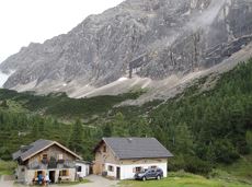
Hike to the Gaudeamushütte mountain hut by the Wilder Kaiser
Wochenbrunner Alm, Ellmau (1,085 m)
Gaudeamushütte, Going (1,263 m)
Wandelen
Gemakkelijk
0:35 u
1,3 km
200 Hoogtemeters

Stripsenjochhaus – Stripsenkopf – Feldberg – Scheibenbichlalmen – Griesenau – Gasteig
Stripsenjochhaus, St. Johann in Tirol (1,577 m)
Gasteig (750 m)
Wandelen
Normaal
6:30 u
16,1 km
640 Hoogtemeters