


 Deutsch
 English
Cross-country skiing and hiking route Sonnbichl/Dorfbichl

Explore the sunny foot of the Pölven mountain.
Langlaufen
Gemakkelijk
0,9 km
De door u opgevraagde pagina is niet beschikbaar. U bent welkom om een nieuwe zoekopdracht op deze pagina te starten.
Explore the sunny foot of the Pölven mountain.
Langlaufen
Gemakkelijk
0,9 km
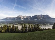
Embark on a sunny cross-country safari in the snowfields around the Sölllandl.
Spar super market Söll
Spar super market Söll
Langlaufen
Normaal
5,9 km
70 Hoogtemeters

Varied and challenging loop over the Scheffauer summit.
Kaindlhütte, Scheffau (1,293 m)
Scheffauer (2,111 m)
Wandelen
Moeilijk
8:30 u
13,0 km
1400 Hoogtemeters

Via ferrata

Baumgartenköpfl (Bergsteigergrab) – Wilder-Kaiser-Steig – Jubiläumssteig – Gruttenhütte
Brennender Palven (1,572 m)
Gruttenhütte, Ellmau (1,620 m)
Wandelen
Moeilijk
2:30 u
3,3 km
410 Hoogtemeters
Circular cycling route for leisure bikers between the four villages of the Kaiser region.
anywhere along the tour
anywhere along the tour
Fietsen
Normaal
38,5 km
550 Hoogtemeters

Difficulty D + spectacular two-rope bridge
Via ferrata

Pure adrenaline is the motto of the Pölven trail on the third day of the Tour de Tirol
Hiking starting point Tourist Info, Söll (689 m)
Hiking starting point Tourist Info, Söll (689 m)
Hardlopen
Normaal
22,8 km
1110 Hoogtemeters

Alpine klimroutes

A tour of the main filming locations of the TV series “Der Bergdoktor” (The Mountain Doctor) in Ellmau and Going, with a refreshment stop at the inn used during filming
Hiking starting point Tourist Info, Ellmau (800 m)
Hiking starting point Tourist Info, Ellmau (800 m)
Wandelen
Gemakkelijk
4:15 u
11,4 km
180 Hoogtemeters

Ellmau hiking info point - Gasthof Au - Ellmauer Hof - Haflingertränke - Auwald - Ellmau hiking info point
Hiking starting point Tourist Info, Ellmau (800 m)
Hiking starting point Tourist Info, Ellmau (800 m)
Hardlopen
Gemakkelijk
1:30 u
9,8 km
300 Hoogtemeters

"Enjoyable" winter hike with a cozy stop and a fantastic panorama.
Hiking starting point Tourist Info, Ellmau (800 m)
Hiking starting point Tourist Info, Ellmau (800 m)
Wandelen
Gemakkelijk
4:30 u
10,5 km
370 Hoogtemeters

A run during which you can enjoy peace and quiet in the great outdoors.
Starting point Scheffau Tourist Information Office (752 m)
Starting point Scheffau Tourist Information Office (752 m)
Hardlopen
Normaal
6,1 km
260 Hoogtemeters

Explore the village Scheffau on a circuit run
Starting point Scheffau Tourist Information Office (752 m)
Starting point Scheffau Tourist Information Office (752 m)
Hardlopen
Gemakkelijk
5,6 km
120 Hoogtemeters

Peace and strength, slow down and take a deep breath.
Ahornsee car park, Söll (693 m)
Ahornsee car park, Söll (693 m)
Wandelen
Normaal
4:45 u
12,0 km
220 Hoogtemeters
Following the Stampfangerbach stream on the way to Filzalm lake
Hiking starting point Bergbahn, Söll (725 m)
Hiking starting point Bergbahn, Söll (725 m)
Wandelen
Normaal
3:15 u
9,0 km
620 Hoogtemeters

Wochenbrunner Alm – Gruttenhühtte
Hiking starting point Wochenbrunner Alm, Ellmau (1,085 m)
Gaudeamushütte, Going (1,263 m)
Wandelen
Normaal
1:45 u
2,6 km
530 Hoogtemeters
This short and easy valley circuit takes you around the village of Going am Wilden Kaiser and past the bathing lake, a delightful spot to cool off in fine weather.
Hiking starting point Going center (former tourist information Going) (764 m)
Hiking starting point Going center (former tourist information Going) (764 m)
Wandelen
Gemakkelijk
1:00 u
6,4 km
110 Hoogtemeters

It’s up and away to a popular inn in Söll.
Hiking starting point Tourist Info, Söll (689 m)
Stallhäusl, Söll (972 m)
Fietsen
Normaal
6,1 km
310 Hoogtemeters

The best seat in the house for a view of the Wilder Kaiser!
Hiking starting point Going center (former tourist information Going) (764 m)
Hiking starting point Going center (former tourist information Going) (764 m)
Wandelen
Gemakkelijk
2:15 u
5,8 km
290 Hoogtemeters
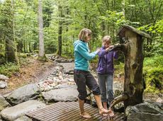
Refreshing walk through the Kneipp facilities and adventures in the Rehbachklamm gorge
Hiking starting point Tourist Info, Scheffau (738 m)
Hiking starting point Tourist Info, Scheffau (738 m)
Wandelen
Normaal
2:00 u
7,1 km
330 Hoogtemeters

This 3-part Via Ferrata features a rope bridge and an extremely difficult exit option.
Via ferrata

This easy family hike takes you via the Bergdoktorhaus to the Berggasthof Hochschwendt mountain inn.
Wanderstartplatz Tourist Info, Ellmau (800m)
Wanderstartplatz Tourist Info, Ellmau (800m)
Wandelen
Gemakkelijk
2:45 u
8,7 km
270 Hoogtemeters

Hike from the centre of Ellmau, along trail no. 14, through the "Spatlahner gorge" up to the Wochenbrunner Alm.
Hiking starting point Tourist Information Office, Ellmau (800 m)
Hiking starting point Tourist Information Office, Ellmau (800 m)
Wandelen
Gemakkelijk
1:30 u
4,4 km
285 Hoogtemeters

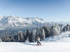
Difficult piste tour via the downhill, route no. 40a to Hochsöll Hexenwasser mountain station & further on via the Keat downhill route no. 43 to the Keat alpine pastures.
Cable Car Söll, ski touring car park
Mountain station, Hexenwasser gondola or Keat Almen
Skitocht
Moeilijk
1:30 u
4,0 km
762 Hoogtemeters

Enjoy winter silence and an imperial panorama in Söll.
parking area Ahornsee, Söll (693 m)
parking area Ahornsee, Söll (693 m)
Langlaufen
Normaal
5,3 km
80 Hoogtemeters

Walk through the forest, along the river, back to the village.
Hiking starting point Tourist Info, Söll (689 m)
Hiking starting point Tourist Info, Söll (689 m)
Wandelen
Gemakkelijk
1:45 u
6,3 km
90 Hoogtemeters

Very demanding round tour to the two eastern peaks in the Wilder Kaiser.
Hiking starting point Tannbichl, Going (857 m)
Hiking starting point Tannbichl, Going (857 m)
Wandelen
Moeilijk
9:00 u
13,0 km
1570 Hoogtemeters

Fork 823/826 – via waterfall – Veitskirche – Steiner-Hochalm
Fork on the Wilder-Kaiser-Steig 823/826 (1,405 m)
Steiner-Hochalm, Scheffau (1,257 m)
Wandelen
Normaal
2:30 u
3,8 km
360 Hoogtemeters

The Kitzbüheler Horn Via Ferrata offers a Magnificent Climbing Adventure for Less Experienced Climbers. Enjoy Spectacular Views and Adrenaline Rushes while being Safe and Secure throughout Your Journey.
Via ferrata
Mittelschwierige Aufstiegsroute entlang der Piste Nr. 80 auf den Hartkaiser.
Hartkaiserbahn Talstation,
Hartkaiserbahn Bergstation, Ellmau (1.520 m)
Skitocht
Normaal
2:00 u
3,5 km
700 Hoogtemeters

The Kaiser Marathon - 42 km and 2,300 metres of elevation gain. A welcome challenge for our top athletes!
Söll village centre
Hohe Salve mountain
Hardlopen
Normaal
42,0 km
2260 Hoogtemeters

Gaudeamushütte - Ellmauer Tor - Klammlweg - Gruttenhütte
Gaudeamushütte, Going (1,263 m)
Gruttenhütte, Ellmau (1,620 m)
Wandelen
Normaal
4:45 u
5,9 km
990 Hoogtemeters

Themed hiking route with a trail full of natural experiences alongside the refreshing water.
Hiking starting point Tourist Info, Scheffau (738 m)
Hiking starting point Tourist Info, Scheffau (738 m)
Wandelen
Normaal
2:30 u
7,2 km
300 Hoogtemeters

Intermediate circular hike with breathtaking views on the surrounding mountains. Attention: Trail no 828 is closed due to danger of falling rocks. Detour via path no. 816 and 827 via the Obere Regalm to the Baumgartenköpfl.
Hiking starting point Tannbichl, Going (857 m)
Hiking starting point Tannbichl, Going (857 m)
Wandelen
Normaal
4:45 u
9,8 km
760 Hoogtemeters

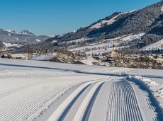
Imperial glide on the sun track
Langlaufen
Gemakkelijk
3,8 km
70 Hoogtemeters

From the Bergdoktorhaus to the Rübezahl-Alm mountain hut and the Carved Figures path to Ellmi’s Zauberwelt.
Hiking starting point Tourist Info, Ellmau (800 m)
Hiking starting point Tourist Info, Ellmau (800 m)
Wandelen
Gemakkelijk
5:30 u
15,8 km
730 Hoogtemeters

Alpine klimroutes

Ideal circuit for beginners to start exercising
Tourist Information Office, Going (766 m)
Tourist Information Office, Going (766 m)
Hardlopen
Gemakkelijk
0:20 u
3,1 km
75 Hoogtemeters
Atmospheric winter hike right into the Wilder Kaiser.
Bathing lake, Going (742 m)
Graspoint-Niederalm, Going (981 m)
Wandelen
Gemakkelijk
2:30 u
5,7 km
250 Hoogtemeters