


 Deutsch
 English
Path of reflection

Leisurely path of reflection to the St. Anna chapel at Lengau
Parkplatz Liftstation Itter (655 m)
Lengauer Kapelle
Wandelen
Gemakkelijk
1:15 u
3,2 km
270 Hoogtemeters
De door u opgevraagde pagina is niet beschikbaar. U bent welkom om een nieuwe zoekopdracht op deze pagina te starten.
Leisurely path of reflection to the St. Anna chapel at Lengau
Parkplatz Liftstation Itter (655 m)
Lengauer Kapelle
Wandelen
Gemakkelijk
1:15 u
3,2 km
270 Hoogtemeters

Experience culinaric highlights for the whole family.
Bergstation Rabennest (1.150 m)
Bergstation Rabennest (1.150 m)
Wandelen
Gemakkelijk
0:40 u
1,7 km
90 Hoogtemeters

Above Lake Reintal in Kramsach. Easy to reach, perfect infrastructure (parking, lake for bathing, restaurants, buses) and short access route; indescribably beautiful views over the lakes and the Lower Inn Valley. For experienced climbers!
Via ferrata

Gentle cycle tour from Wörgl via Söll, Scheffau, Ellmau and Going to St. Johann or vice versa!
Wörgl (511 m)
St. Johann (660 m)
Fietsen
Normaal
38,2 km
450 Hoogtemeters

Enjoy unspoilt views of the Sölllandl region from snow-covered fields.
Hiking starting point Franzlhof, Söll (703 m)
Hiking starting point Franzlhof, Söll (703 m)
Wandelen
Gemakkelijk
2:15 u
5,8 km
100 Hoogtemeters

circuit tour with breathtaking panorama
Astberg Bergstation
Astberg Bergstation
Wandelen
Gemakkelijk
1:20 u
4,1 km
140 Hoogtemeters
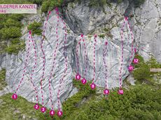
34 magnificent routes with a fantastic panoramic view of the summits.
Sportklimmen

Looping the village of Söll, the sight seeing hike!
Hiking starting point Tourist Info, Söll (689 m)
Hiking starting point Tourist Info, Söll (689 m)
Wandelen
Gemakkelijk
1:00 u
3,7 km
50 Hoogtemeters

Picture-postcard panoramic scenery to Hintersteiner See lake, a natural gem.
Villag Center, Söll (689 m)
Hintersteiner See Lake, Scheffau (889 m)
Fietsen
Normaal
9,4 km
430 Hoogtemeters

Via ferrata

Hartkaiserbahn summit station - Ellmis Zauberwald - Tanzbodensee lake - Hartkaiserbahn summit station
Hartkaiser summit station, Ellmau (1,555 m)
Hartkaiser summit station, Ellmau (1,555 m)
Hardlopen
Gemakkelijk
3,4 km
120 Hoogtemeters

Alpine klimroutes

Snowshoe hike via the Kaiseralmen with starting and finishing at the Gasthof Jägerwirt.
Gasthof Jägerwirt, Scheffau (883 m)
Gasthof Jägerwirt, Scheffau (883 m)
Wandelen
Normaal
3:15 u
4,8 km
250 Hoogtemeters

Family-friendly, leisurely circular hike around the Astberg mountain
Astberg mountain station, Going (1.251 m)
Astberg mountain station, Going (1.251 m)
Wandelen
Gemakkelijk
0:30 u
1,5 km
80 Hoogtemeters

From the flowery village to the water jewel of the Alps.
Hiking starting point Franzlhof, Söll (703 m)
Seestüberl restaurant, Hintersteiner See, Scheffau (890 m)
Wandelen
Normaal
3:15 u
9,5 km
460 Hoogtemeters

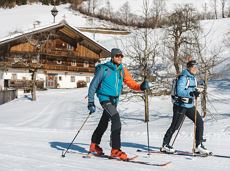
Cross-country skiing and hiking route through a delightful winter landscape via the Auwald and Niederachen districts.
Langlaufen
Gemakkelijk
3,6 km
10 Hoogtemeters

Beautiful, Alpine sport climbing with consistent difficulty.
Alpine klimroutes

Cozy winter tour in Hochsöll with lift support, refreshments and view to the Hohe Salve.
Mountain station gondola Hexenwasser, Söll (1,150 m)
Mountain station gondola Hexenwasser, Söll (1,150 m)
Wandelen
Gemakkelijk
1:30 u
3,2 km
100 Hoogtemeters
Hike via four mountain huts Rübezahl-Alm, Jägerhütte and Hochschwendt.
Hiking starting point Tourist Info, Ellmau (800 m)
Hiking starting point Tourist Info, Ellmau (800 m)
Wandelen
Gemakkelijk
6:15 u
14,0 km
600 Hoogtemeters

A picturesque mountain hike that leads from the turquoise waters of the most beautiful mountain lake in Tirol up to the rustic Alpine village.
Hiking starting point Seestüberl, Scheffau (890 m)
Hiking starting point Seestüberl, Scheffau (890 m)
Wandelen
Normaal
3:15 u
9,3 km
360 Hoogtemeters
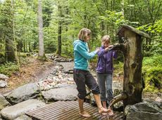
Refreshing walk through the Kneipp facilities and adventures in the Rehbachklamm gorge
Hiking starting point Tourist Info, Scheffau (738 m)
Hiking starting point Tourist Info, Scheffau (738 m)
Wandelen
Normaal
2:00 u
7,1 km
330 Hoogtemeters

A circular route full of experiences that leads from the Seebachgraben gorge to the Wilder-Kaiser-Steig trail - discover one of the most beautiful parts of Scheffau!
Hiking starting point Tourist Info, Scheffau (738 m)
Hiking starting point Tourist Info, Scheffau (738 m)
Wandelen
Normaal
7:00 u
19,6 km
1140 Hoogtemeters

Following the Stampfangerbach stream on the way to Filzalm lake
Hiking starting point Bergbahn, Söll (725 m)
Hiking starting point Bergbahn, Söll (725 m)
Wandelen
Normaal
3:15 u
9,0 km
620 Hoogtemeters

A wonderful tour up to the Astberg lake via the Hollenauer Cross with dream views
Astbergbahn valley station, Going (805 m)
Astbergsee, Going (1.251m)
Wandelen
Gemakkelijk
3,0 km
465 Hoogtemeters

All routes of the competitions Kaiserkrone Trail - the imperial trail running event in Scheffau am Wilden Kaiser!
Hardlopen
Moeilijk
115,0 km
8460 Hoogtemeters

Exciting round trip for adults and children through the Rehbach gorge.
Hiking starting point Tourist Info, Scheffau (738 m)
Hiking starting point Tourist Info, Scheffau (738 m)
Wandelen
Normaal
2:00 u
5,5 km
280 Hoogtemeters

This pleasant circular walk takes you to Söll’s war memorial in a beautiful section of forest.
Hiking starting point Tourist Info, Söll (689 m)
Hiking starting point Tourist Info, Söll (689 m)
Wandelen
Gemakkelijk
0:30 u
2,1 km
10 Hoogtemeters
Mittelschwierige Aufstiegsroute entlang der Piste Nr. 80 auf den Hartkaiser.
Hartkaiserbahn Talstation,
Hartkaiserbahn Bergstation, Ellmau (1.520 m)
Skitocht
Normaal
2:00 u
3,5 km
700 Hoogtemeters
Easy piste tour via the family descent/moon toboggan run Route 40 (blue) to Hochsöll.
Cable Car Söll, ski touring car park
Mountain station, Hexenwasser gondola
Skitocht
Gemakkelijk
1:30 u
4,3 km
410 Hoogtemeters

Via ferrata

Very demanding round tour to the two eastern peaks in the Wilder Kaiser.
Hiking starting point Tannbichl, Going (857 m)
Hiking starting point Tannbichl, Going (857 m)
Wandelen
Moeilijk
9:00 u
13,0 km
1570 Hoogtemeters

Hike from the Kaiserlift mountain station via the Kaindlhütte and Walleralm to Hintersteiner See.
Mountain station Kaiserlift, Kufstein (1256 m)
Hiking starting point Seestüberl, Scheffau (890 m)
Wandelen
Normaal
3:20 u
8,8 km
340 Hoogtemeters

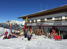
Exciting adventure stations for family tobogganing on the Hohe Salve.
Cable car valley station, Söll (725 m)
Cable car valley station, Söll (725 m)
Rodelen
Gemakkelijk
4,0 km

Two very demanding, fantastic lookout peaks on the Wilder Kaiser, which are not to be underestimated.
Hiking starting point Wegscheid, Scheffau (883 m)
Hiking starting point Wegscheid, Scheffau (883 m)
Wandelen
Moeilijk
9:00 u
11,0 km
1440 Hoogtemeters
This short and easy valley circuit takes you around the village of Going am Wilden Kaiser and past the bathing lake, a delightful spot to cool off in fine weather.
Hiking starting point Going center (former tourist information Going) (764 m)
Hiking starting point Going center (former tourist information Going) (764 m)
Wandelen
Gemakkelijk
1:00 u
6,4 km
110 Hoogtemeters
Going, Hüttling - Schleierwasserfall - Obere Regalm - Baumgartenköpfl (Bergsteigergrab) - Gaudeamushütte
Hiking starting point Hüttling, Going (820 m)
Gaudeamushütte, Going (1,263 m)
Wandelen
Normaal
4:00 u
7,3 km
860 Hoogtemeters
Cozy winter walk through the snowy witch water.
Mountain station gondola Hexenwasser, Söll (1,150 m)
Mountain station gondola Hexenwasser, Söll (1,150 m)
Wandelen
Gemakkelijk
0:30 u
1,2 km
45 Hoogtemeters

A wild and romantic walk through the Kaiserwald forest with its wildlife park and cosy, traditional Tirolean parlour.
Hiking starting point Tourist Info, Ellmau (800 m)
Hiking starting point Tourist Info, Ellmau (800 m)
Wandelen
Normaal
3:30 u
9,0 km
300 Hoogtemeters

Varied round tour with many refreshments and wonderful views
Tourist Information Office, Scheffau (737 m)
Tourist Information Office, Scheffau (737 m)
Fietsen
Normaal
23,6 km
660 Hoogtemeters

A hike on varied paths around the Achleitberg.
Hiking starting point Tourist Info, Scheffau (738 m)
Hiking starting point Tourist Info, Scheffau (738 m)
Wandelen
Normaal
5:45 u
18,0 km
540 Hoogtemeters