Hoppala, route niet gevonden

De door u opgevraagde pagina is niet beschikbaar. U bent welkom om een nieuwe zoekopdracht op deze pagina te starten.

0 Routes & tochten

Schattseit trail route

Schattseit trail route

Quietness, strength and with easy breathing steadily closer to the Wilder Kaiser. You can return on foot or by bus.

Hiking starting point Bergbahn, Söll (724 m)

Gasthof Bocking, Söll (665 m)

Wandelen

Gemakkelijk

1:45 u

5,5 km

100 Hoogtemeters

Hartkaiserweg trail Ellmau

Hartkaiserweg trail Ellmau

Ellmau village park - Hartkaiserbahn valley station - Bergschenke - Rübezahlalm - Jägerhütte - Hartkaiser summit station

Hiking starting point Tourist Info, Ellmau (800 m)

Hartkaiser summit station, Ellmau (1,555 m)

Hardlopen

Normaal

8,2 km

720 Hoogtemeters

Kaiser circular cycling route

Kaiser circular cycling route

Calling bike fans of all ability levels! The Kaiser circular cycling route is an 80-kilometre bike route through the spectacular scenery of the Kaisergebirge mountain range. An excellent network of well-signposted trails (a mix of asphalt and gravel paths) leads past idyllic nature, breathtaking panoramas and cultural sights. For relaxing moments in between stages, cool lakes and local restaurants invite you to linger and enjoy.

anywhere along the tour

anywhere along the tour

Fietsen

Normaal

83,0 km

700 Hoogtemeters

Lama circuit Ellmau

Lama circuit Ellmau
Lama circuit Ellmau
Lama circuit Ellmau

Ellmau hiking info point - Gasthof Au - Ellmauer Hof - Haflingertränke - Auwald - Ellmau hiking info point

Hiking starting point Tourist Info, Ellmau (800 m)

Hiking starting point Tourist Info, Ellmau (800 m)

Hardlopen

Gemakkelijk

1:30 u

9,8 km

300 Hoogtemeters

Circuit around Going

Circuit around Going

The circuit around Going is a lengthy and demanding tour with a great variety of different sections.

Tourist Information Office, Going (766 m)

Tourist Information Office, Going (766 m)

Hardlopen

Normaal

1:25 u

11,2 km

280 Hoogtemeters

Kaiserkrone - stage 4

Kaiserkrone - stage 4

Stripsenjochhaus – Stripsenkopf – Feldberg – Scheibenbichlalmen – Griesenau – Gasteig

Stripsenjochhaus, St. Johann in Tirol (1,577 m)

Gasteig (750 m)

Wandelen

Normaal

6:30 u

16,1 km

640 Hoogtemeters

Rehbachklamm

Rehbachklamm
Rehbachklamm
Rehbachklamm

Themed hiking route with a trail full of natural experiences alongside the refreshing water.

Hiking starting point Tourist Info, Scheffau (738 m)

Hiking starting point Tourist Info, Scheffau (738 m)

Wandelen

Normaal

2:30 u

7,2 km

300 Hoogtemeters

Eagle Walk Stage 01: St. Johann in Tirol - Gaudeamushütte

Eagle Walk Stage 01: St. Johann in Tirol - Gaudeamushütte

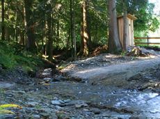
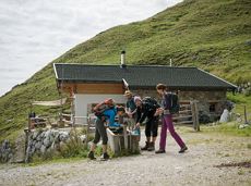
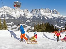
Sturdy boots will help keep your ankles and feet happy on this hike, full of the best things Tirol has to offer: well-maintained trails, wildflowers galore and waterfalls beckon the adventurous hiker ready for a strenuous climb with breathtaking views of lofty Wilder Kaiser Mountain Range as your reward. The nature reserve’s landscape will win you over with its diverse beauty. The pasture regions are covered with soft grassy meadows, and hikers are greeted by lofty Wilder Kaiser Mountain Range with rugged Maukspitze, Ackerlspitze, Regalpspitze and Törlspitze Peaks, all “Two-Thousanders” that average 2,000 metres altitude. Trailhead is Rummlerhof Inn, northwest of the village centre of St. Johann. After a successful first segment, why not take a rest at Gaudeamus Hut, raise your glass and sing: “Gaudeamus igitur – Let us be happy!” For many hikers this is far enough, contentment has already set in. Adventurous souls continue on the trail that works its way up across Klamml Gorge to Grutten Hut, which entails another 400 metres of climbing.

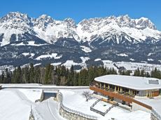
Rummlerhof, St.Johann in Tirol
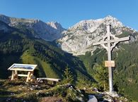
Gaudeamushütte

Wandelen

Normaal

5:00 u

13,0 km

1060 Hoogtemeters

Prama circular winter hiking route

Prama circular winter hiking route

Sunny walk over snowfields with enchanting landscape. An easy and enjoyable circuit in Going for the whole family.

Hiking starting point Going center (former tourist information Going) (764 m)

Hiking starting point Going center (former tourist information Going) (764 m)

Wandelen

Gemakkelijk

3:00 u

7,9 km

80 Hoogtemeters

Bergdoktor circular route Söll

Bergdoktor circular route Söll

Off the beaten track up to the Köpfing farmhouse. “Der Bergdoktor” (The Mountain Doctor) is a famous German-Austrian TV series, which is produced in the Wilder Kaiser region.

Bergdoktor parking lot, Söll

Bergdoktor parking lot, Söll

Wandelen

Gemakkelijk

3:00 u

8,4 km

370 Hoogtemeters

Sonnseitrunde circuit Ellmau

Sonnseitrunde circuit Ellmau

Ellmau hiking info point - Wimm - Riesen - Biedringer Alm - Biedringer Bauernhöfe - Ellmauer Kaiserbad - Ellmau hiking info point

Hiking starting point Tourist Info, Ellmau (800 m)

Hiking starting point Tourist Info, Ellmau (800 m)

Hardlopen

Gemakkelijk

9,8 km

400 Hoogtemeters

Quellen circular route

Quellen circular route

Enjoy the scenic area of the Hohe Salve where the Söll waters originate.

Exit Keat chairlift, Söll (1,533 m)

Exit Keat chairlift, Söll (1,533 m)

Wandelen

Normaal

3:45 u

10,3 km

530 Hoogtemeters

Hollenauer Kreuz winter hiking route

Hollenauer Kreuz winter hiking route

Climb to the best viewpoint in the mountains, where the Wilder Kaiser is within touching distance.

Hiking starting point Going center (former tourist information Going) (764 m)

Hiking starting point Going center (former tourist information Going) (764 m)

Wandelen

Normaal

4:30 u

10,7 km

360 Hoogtemeters

Kaiser view circular walk

Kaiser view circular walk

Extended walk through the landscape of Scheffau and Söll

Hiking starting point Tourist Info, Scheffau (738 m)

Hiking starting point Tourist Info, Scheffau (738 m)

Wandelen

Gemakkelijk

3:30 u

8,8 km

210 Hoogtemeters

Winter hiking route Hochsöll

Winter hiking route Hochsöll

Cozy winter tour in Hochsöll with lift support, refreshments and view to the Hohe Salve.

Mountain station gondola Hexenwasser, Söll (1,150 m)

Mountain station gondola Hexenwasser, Söll (1,150 m)

Wandelen

Gemakkelijk

1:30 u

3,2 km

100 Hoogtemeters

Lake Reintal via ferrata

Lake Reintal via ferrata

Above Lake Reintal in Kramsach. Easy to reach, perfect infrastructure (parking, lake for bathing, restaurants, buses) and short access route; indescribably beautiful views over the lakes and the Lower Inn Valley. For experienced climbers!

Via ferrata

Jubiläumssteig trail

Jubiläumssteig trail

Experience impressive low and panoramic views in the unique rocky scenery of the legendary "Wild Castle", as this area is known according to legend thanks to its many turrets, peaks, hollows and balconies.

Wochenbrunner Alm, Ellmau (1.085 m)

Wochenbrunner Alm, Ellmau (1.085 m)

Wandelen

Moeilijk

3:45 u

6,3 km

630 Hoogtemeters

Hausberg

Hausberg
Hausberg
Hausberg

An ascent that is rewarded with refreshments. Back to the valley with the toboggan, the lift or on foot.

Village centre, Ellmau (800 m)

Astbergbahn, Going (804 m)

Wandelen

Gemakkelijk

2:45 u

5,8 km

460 Hoogtemeters

Eagle Walk Stage 02: Gaudeamushütte - Kaindlhütte

Eagle Walk Stage 02: Gaudeamushütte - Kaindlhütte

Is it about the journey or the destination? Well, one of the destinations of this stage is definitely the Hintersteiner See lake and its views. Surrounded by stunning mountain vistas, dwarf pine scrubland and beech forests, the lake is one of the cleanest and most beautiful mountain lakes in Tirol. The private pristine gem covers 56 hectares and measures 36 metres at its deepest point. With this picture-perfect backdrop, hikers will complete the remaining distance to the Kaindlhütte hut in no time.

Gaudeamushütte

Hintersteiner See

Wandelen

Normaal

6:30 u

15,1 km

888 Hoogtemeters

Ellmauer Tor

Ellmauer Tor
Ellmauer Tor
Ellmauer Tor

Challenging adventure hike to the Ellmauer Tor

Hiking starting point Wochenbrunner Alm, Ellmau (1,085 m)

Ellmauer Tor, Ellmau (2,001 m)

Wandelen

Normaal

5:00 u

7,7 km

900 Hoogtemeters