


 Deutsch
 English
Fitness parcours "Forstmeile" Ellmau

Ellmau hiking info - Gasthof Au - Forstmeile Ellmau
District "Steinerner Tisch", Ellmau
District "Steinerner Tisch", Ellmau
Hardlopen
Gemakkelijk
1,9 km
75 Hoogtemeters
Ellmau hiking info - Gasthof Au - Forstmeile Ellmau
District "Steinerner Tisch", Ellmau
District "Steinerner Tisch", Ellmau
Hardlopen
Gemakkelijk
1,9 km
75 Hoogtemeters
 Open
OpenVia ferrata

Hikers exploring Tirol on foot will feel as free as a bird. The eagle walk is one of the 'Great Walks' of Tyrol chosen by a jury. They offer hikers the chance to get away from it all, discover the beauty of nature and experience a true adventure in the Alps.
St. Johann in Tirol
Arlbergpass
Wandelen
Moeilijk
426,0 km
30000 Hoogtemeters

Explore Going on the village circular tour and get to knowone or two hidden corners of our quiet, idyllic, artisan village with panoramic views of the Wilder Kaiser from a different angle.
Hiking starting point Going center (former tourist information Going) (764 m)
Hiking starting point Going center (former tourist information Going) (764 m)
Wandelen
Gemakkelijk
1:15 u
4,2 km
60 Hoogtemeters

A beautiful easy hike at the foot of the Wilder Kaiser
Hiking starting point Tourist Info, Ellmau (800 m)
Hiking starting point Tourist Info, Ellmau (800 m)
Wandelen
Gemakkelijk
1:45 u
5,9 km
60 Hoogtemeters

Hike along the sunny side along field paths and settlements from Scheffau to Ellmau..
Hiking starting point, Tourismus Info, Scheffau (737 m)
Bus stop Ellmau Bauhof/Dorf, Ellmau (800 m)
Wandelen
Gemakkelijk
1:30 u
5,7 km
100 Hoogtemeters

A tour of the main filming locations of the TV series “Der Bergdoktor” (The Mountain Doctor) in Ellmau and Going, with a refreshment stop at the inn used during filming
Hiking starting point Tourist Info, Ellmau (800 m)
Hiking starting point Tourist Info, Ellmau (800 m)
Wandelen
4:15 u
11,4 km
180 Hoogtemeters

Approaching from the north, this trail leads through the Steinerne Rinne to the majestic Ellmauer Tor.
Griesner Alm, 988 m
Wochenbrunner Alm, Ellmau (1,085 m)
Wandelen
Moeilijk
5:45 u
8,1 km
1060 Hoogtemeters

Challenging adventure hike to the Ellmauer Tor
Hiking starting point Wochenbrunner Alm, Ellmau (1,085 m)
Ellmauer Tor, Ellmau (2,001 m)
Wandelen
Normaal
5:00 u
7,7 km
900 Hoogtemeters

From the flowery village to the water jewel of the Alps.
Hiking starting point Franzlhof, Söll (703 m)
Seestüberl restaurant, Hintersteiner See, Scheffau (890 m)
Wandelen
Normaal
3:15 u
9,5 km
460 Hoogtemeters
 Open
OpenVia ferrata

Turnoff to Granderalm – Schleier Waterfall – Going, Hüttling
First turnoff after the Granderalm
Hiking starting point Hüttling, Going (820 m)
Wandelen
Normaal
2:00 u
3,1 km
40 Hoogtemeters

Hiking starting point Tourist Info, Scheffau (737 m)
Hiking starting point Tourist Info, Scheffau (737 m)
Wandelen
Gemakkelijk
3:45 u
11,2 km
410 Hoogtemeters

A demanding mountain tour with some ferrata passages up to the highest summit in the Wilder Kaiser (2,344 m).
Hiking starting point Wochenbrunner Alm, Ellmau (1,085 m)
Hiking starting point Wochenbrunner Alm, Ellmau (1,085 m)
Wandelen
Moeilijk
7:30 u
9,3 km
1250 Hoogtemeters

A unique hike to the highest mountain hut in the Wilder Kaiser region featuring a panoramic view.
Hiking starting point Going center (former tourist information Going) (764 m)
Hiking starting point Going center (former tourist information Going) (764 m)
Wandelen
Normaal
5:45 u
14,2 km
860 Hoogtemeters
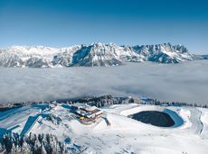
Hartkaiserbahn summit station - Ellmis Zauberwald - Tanzbodensee lake - Hartkaiserbahn summit station
Hartkaiser summit station, Ellmau (1,555 m)
Hartkaiser summit station, Ellmau (1,555 m)
Hardlopen
Gemakkelijk
3,4 km
120 Hoogtemeters

Quietness, strength and with easy breathing steadily closer to the Wilder Kaiser. You can return on foot or by bus.
Hiking starting point Bergbahn, Söll (724 m)
Gasthof Bocking, Söll (665 m)
Wandelen
Gemakkelijk
1:45 u
5,5 km
100 Hoogtemeters

This well-secured sport climbing route features interesting lines in prime rock.
Alpine klimroutes

Varied hike with cosy refreshment stops and a wonderful mountain panorama.
mountain station Salvistabahn / Kleine Salve
Middle station Salvistabahn Itter
Wandelen
Normaal
2:45 u
7,4 km
360 Hoogtemeters

Imperial glide on the sun track
Langlaufen
Gemakkelijk
3,8 km
70 Hoogtemeters

Alpine klimroutes

The best hiking routes from village centre Scheffau to Lake Hinterstein.
Community Hall, Scheffau (740 m)
Hintersteiner See, Scheffau (890 m)
Wandelen
Normaal
1:30 u
4,5 km
240 Hoogtemeters

A challenging circular mountainbike tour with plenty of welcoming refreshment stops.
Village Center, Söll (703 m)
Village Center, Söll (703 m)
Fietsen
Normaal
28,5 km
950 Hoogtemeters

"Enjoyable" winter hike with a cozy stop and a fantastic panorama.
Hiking starting point Tourist Info, Ellmau (800 m)
Hiking starting point Tourist Info, Ellmau (800 m)
Wandelen
4:30 u
10,5 km
370 Hoogtemeters

Hike to the Gruttenhütte with great views to the Ellmauer Halt and the entire region.
Hiking starting point Tourist Info, Scheffau (738 m)
Gruttenhütte, Ellmau (1,620 m)
Wandelen
Normaal
6:30 u
16,4 km
990 Hoogtemeters

Short beginners’ trail - central, easy and crisp!
Langlaufen
Gemakkelijk
1,0 km
A short winter walk on Hartkaiser hrough Ellmi's magical world.
Hiking starting point Tourist Info, Ellmau (800 m)
Hiking starting point Tourist Info, Ellmau (800 m)
Wandelen
0:30 u
1,0 km
25 Hoogtemeters

An extensive exploration of the “Moor & more”. Exciting puzzle tour with Rocky through the Kaiserwald forest is sure to be lots of fun, even for older children.
Hiking starting point Hüttling, Going (820 m)
Hiking starting point Hüttling, Going (820 m)
Wandelen
Gemakkelijk
3:00 u
8,0 km
380 Hoogtemeters

Dizzying experience via snack stations to the waterfall via unmanaged alpine pastures to the Hexenwasser. Return to the valley by cable car or on foot.
Hiking starting point Bergbahn, Söll (725 m)
Hiking starting point Bergbahn, Söll (725 m)
Wandelen
Normaal
2:00 u
5,6 km
500 Hoogtemeters
 Open
OpenDifficulty D - two sections and a spectacular two-rope bridge.
Via ferrata

Themed hiking route with a trail full of natural experiences alongside the refreshing water.
Hiking starting point Tourist Info, Scheffau (738 m)
Hiking starting point Tourist Info, Scheffau (738 m)
Wandelen
Normaal
2:30 u
7,2 km
300 Hoogtemeters

Alpine klimroutes

Strength is born of calmness – and the summit cross of the Brandstadl is no exception
Cable car valley station, Söll (725 m)
Cable car valley station, Söll (725 m)
Wandelen
Normaal
3:00 u
5,6 km
910 Hoogtemeters

Going, Hüttling - Schleierwasserfall - Obere Regalm - Baumgartenköpfl (Bergsteigergrab) - Gaudeamushütte - Ellmauer Tor - Hintere Goinger Halt - Jubiläumssteig - Gruttenhütte - Kaiser-Hochalm - Steiner-Hochalm - Hinterschießling Alm - Rehbachklamm - Scheffau, Dorf
Hiking starting point Hüttling, Going (820 m)
Scheffau village (738 m)
Wandelen
Moeilijk
14:00 u
24,6 km
2060 Hoogtemeters

A nice run around the crystal-clear lake Hintersteiner See.
Starting point Seestüberl, Scheffau (822 m)
Starting point Seestüberl, Scheffau (882 m)
Hardlopen
Gemakkelijk
5,2 km
180 Hoogtemeters

A classic amongst the via ferratas on the Wilder Kaiser massif – ideal as a 2-day tour.
Via ferrata

Imperial glide during the day and at night - on the only night trail.
Langlaufen
Gemakkelijk
1,2 km
30 Hoogtemeters

The Sunnseit circuit lives up to its name - this sunny circular hike leads through a varied landscape with fantastic views of Söll, the Wilder Kaiser, the Hohe Salve and the Pölven massif.
Hiking starting point Franzlhof, Söll (703 m)
Hiking starting point Franzlhof, Söll (703 m)
Wandelen
Gemakkelijk
2:15 u
7,3 km
180 Hoogtemeters

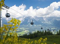
The best seat in the house for a view of the Wilder Kaiser!
Tourist Information Office, Going (766 m)
Tourist Information Office, Going (766 m)
Fietsen
Normaal
2:00 u
7,5 km
350 Hoogtemeters

A walk that lets you experience the Brandstadl mountain and leads you to Jochstubnsee lake.
Brandstadlbahn valley station, Scheffau (681 m)
Brandstadlbahn valley station, Scheffau (681 m)
Wandelen
Gemakkelijk
4:45 u
12,7 km
1130 Hoogtemeters