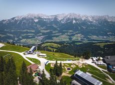
Hoppala, route niet gevonden

De door u opgevraagde pagina is niet beschikbaar. U bent welkom om een nieuwe zoekopdracht op deze pagina te starten.

0 Routes & tochten

Scheffauer summit tour

Scheffauer summit tour

The panoramic Scheffauer is the last high peak in the west at 2,111 m above sea level.

Hiking starting point Bärnstatt, Scheffau (920 m)

Hiking starting point Bärnstatt, Scheffau (920 m)

Wandelen

Moeilijk

7:00 u

7,9 km

1180 Hoogtemeters

Ackerlhütten circular hike

Ackerlhütten circular hike
Gedeeltelijk openAckerlhütten circular hike
Ackerlhütten circular hike

Intermediate circular hike with breathtaking views on the surrounding mountains. Attention: Trail no 828 is closed due to danger of falling rocks. Detour via path no. 816 and 827 via the Obere Regalm to the Baumgartenköpfl.

Hiking starting point Tannbichl, Going (857 m)

Hiking starting point Tannbichl, Going (857 m)

Wandelen

Normaal

4:45 u

9,8 km

760 Hoogtemeters

Winter-Rehbach tour

Winter-Rehbach tour
Winter-Rehbach tour
Winter-Rehbach tour

Enjoy snowy forests and nature in winter.

Hiking starting point Tourist Info, Scheffau (738 m)

Hiking starting point Tourist Info, Scheffau (738 m)

Wandelen

Gemakkelijk

1:45 u

3,8 km

170 Hoogtemeters

Village tour Scheffau

Village tour Scheffau

Round tour through Scheffau with vitalising stations for refreshment and relaxation.

Hiking starting point Tourist Info, Scheffau (738 m)

Hiking starting point Tourist Info, Scheffau (738 m)

Wandelen

Gemakkelijk

1:15 u

4,3 km

90 Hoogtemeters

Kaiserkrone - alternative route crossing through the Ellmauer Tor (Eggersteig trail - Jubiläumssteig trail)

Kaiserkrone - alternative route crossing through the Ellmauer Tor (Eggersteig trail - Jubiläumssteig trail)

Stripsenjochhaus – Eggersteig – Steinerne Rinne – Ellmauer Tor – Jubiläumssteig – Gruttenhütte

Stripsenjochhaus, St. Johann in Tirol (1,577 m)

Gaudeamushütte, Going (1,263 m)

Wandelen

Moeilijk

5:00 u

6,3 km

590 Hoogtemeters

Crystal clear streams

Crystal clear streams

Atmospheric forest walk along the snow-white creek.

Hiking starting point Tourist Info, Scheffau (738 m)

Hiking starting point Tourist Info, Scheffau (738 m)

Wandelen

Normaal

2:00 u

4,2 km

160 Hoogtemeters

Pölvenau circular route

Pölvenau circular route
Gedeeltelijk openPölvenau circular route
Pölvenau circular route

Pleasant circular hiking trail through forests and meadows to the romantically situated moor lake.

Hiking starting point Franzlhof, Söll (703 m)

Hiking starting point Franzlhof, Söll (703 m)

Wandelen

Normaal

2:00 u

5,7 km

240 Hoogtemeters

Bergdoktor e-bike tour “From the village square via the doctor’s practice to the Gruberhof”

Bergdoktor e-bike tour “From the village square via the doctor’s practice to the Gruberhof”

Going church square - Bergdoktor practice Ellmau and Gruberhof Söll. This e-bike tour gives you a chance to enjoy the magnificent mountain panorama at the foot of the Wilder Kaiser and takes you past the three main filming locations of the “Der Bergdoktor” (The Mountain Doctor) TV series.

Going church square

Going church square

Fietsen

Normaal

51,0 km

990 Hoogtemeters

Treffauer & Tuxeck summit tour

Treffauer & Tuxeck summit tour

Two very demanding, fantastic lookout peaks on the Wilder Kaiser, which are not to be underestimated.

Hiking starting point Wegscheid, Scheffau (883 m)

Hiking starting point Wegscheid, Scheffau (883 m)

Wandelen

Moeilijk

9:00 u

11,0 km

1440 Hoogtemeters

Kaiser crag

Kaiser crag
Kaiser crag
Kaiser crag

Along with the Murmeltierfelsen and Gamsfelsen, there are a total of 16 climbing routes of difficulty levels UIAA 3 to 6a+ near the Gaudeamushütte mountain hut.

Sportklimmen

Quellen circular route

Quellen circular route

Enjoy the scenic area of the Hohe Salve where the Söll waters originate.

Exit Keat chairlift, Söll (1,533 m)

Exit Keat chairlift, Söll (1,533 m)

Wandelen

Normaal

3:45 u

10,3 km

530 Hoogtemeters

Kaiserkrone - stage 1

Kaiserkrone - stage 1

Going, Hüttling – Graspoint-Niederalm – Obere Regalm – Brennender Palven – Gaudeamushütte – Klamml – Gruttenhütte

Hiking starting point Hüttling, Going (820 m)

Gaudeamushütte, Going (1,263 m) / Gruttenhütte, Ellmau (1,620 m)

Wandelen

Normaal

4:30 u

8,0 km

1120 Hoogtemeters

Hartkaiser circuit (no. 1 & 3)

Hartkaiser circuit (no. 1 & 3)

From the Bergdoktorhaus to the Rübezahl-Alm mountain hut and the Carved Figures path to Ellmi’s Zauberwelt.

Hiking starting point Tourist Info, Ellmau (800 m)

Hiking starting point Tourist Info, Ellmau (800 m)

Wandelen

Gemakkelijk

5:30 u

15,8 km

730 Hoogtemeters

Schattseitloipe

Schattseitloipe
Schattseitloipe
Schattseitloipe

Enjoy winter silence and an imperial panorama in Söll.

parking area Ahornsee, Söll (693 m)

parking area Ahornsee, Söll (693 m)

Langlaufen

Normaal

5,3 km

80 Hoogtemeters

Bergdoktor tour of Ellmau & Going

Bergdoktor tour of Ellmau & Going

A tour of the main filming locations of the TV series “Der Bergdoktor” (The Mountain Doctor) in Ellmau and Going, with a refreshment stop at the inn used during filming

Hiking info point, Tourist Info Ellmau (800 m)

Hiking info point, Tourist Info Ellmau (800 m)

Wandelen

Gemakkelijk

3:15 u

11,4 km

180 Hoogtemeters