


 Deutsch
 English
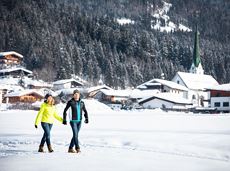
Hiking routes to Lake Hinterstein

The best hiking routes from village centre Scheffau to Lake Hinterstein.
Community Hall, Scheffau (740 m)
Hintersteiner See, Scheffau (890 m)
Wandelen
Normaal
1:30 u
4,5 km
240 Hoogtemeters
De door u opgevraagde pagina is niet beschikbaar. U bent welkom om een nieuwe zoekopdracht op deze pagina te starten.
The best hiking routes from village centre Scheffau to Lake Hinterstein.
Community Hall, Scheffau (740 m)
Hintersteiner See, Scheffau (890 m)
Wandelen
Normaal
1:30 u
4,5 km
240 Hoogtemeters

The Wilder Kaiser always in view.
Ahornsee car park, Söll (693 m)
Hiking starting point Bocking, Söll (670 m)
Wandelen
Gemakkelijk
3:30 u
6,0 km
130 Hoogtemeters

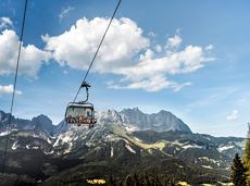
Kufstein – Brentenjoch – Kaindlhütte
Kaiserlift summit station, Kufstein (1,255 m)
Kaindlhütte, Scheffau (1,293 m)
Wandelen
Gemakkelijk
1:30 u
2,9 km
220 Hoogtemeters

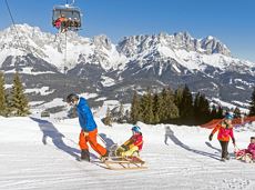
Going, Hüttling – Graspoint-Niederalm – Obere Regalm – Brennender Palven – Gaudeamushütte – Klamml – Gruttenhütte
Hiking starting point Hüttling, Going (820 m)
Gaudeamushütte, Going (1,263 m) / Gruttenhütte, Ellmau (1,620 m)
Wandelen
Normaal
4:30 u
8,0 km
1120 Hoogtemeters

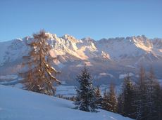
Crystal-clear mountain lake and magnificent views of the Wilder Kaiser’s western summits
Hintersteiner See, Scheffau (890 m)
Hintersteiner See, Scheffau (890 m)
Wandelen
Gemakkelijk
1:30 u
5,2 km
130 Hoogtemeters

Climb to the best viewpoint in the mountains, where the Wilder Kaiser is within touching distance.
Hiking starting point Going center (former tourist information Going) (764 m)
Hiking starting point Going center (former tourist information Going) (764 m)
Wandelen
Normaal
4:30 u
10,7 km
360 Hoogtemeters
Hike via four mountain huts Rübezahl-Alm, Jägerhütte and Hochschwendt.
Hiking starting point Tourist Info, Ellmau (800 m)
Hiking starting point Tourist Info, Ellmau (800 m)
Wandelen
Gemakkelijk
6:15 u
14,0 km
600 Hoogtemeters

Bike tour to the idyllically situated Obere Regalm with a magnificent view.
Tourist Info, Going (764 m)
Tourist Info, Going (764 m)
Fietsen
Normaal
7,3 km
580 Hoogtemeters

Moorland hike suitable for children. The elf will help you discover the special inhabitants of the moor.
Römerhof, St. Johann (769 m)
Römerhof, St. Johann (769 m)
Wandelen
Gemakkelijk
1:30 u
4,3 km
100 Hoogtemeters

Difficult piste tour via the downhill, route no. 40a to Hochsöll Hexenwasser mountain station & further on via the Keat downhill route no. 43 to the Keat alpine pastures.
Cable Car Söll, ski touring car park
Mountain station, Hexenwasser gondola or Keat Almen
Skitocht
Moeilijk
1:30 u
4,0 km
762 Hoogtemeters

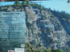
The heart of the tour is the deep, wonderful-to-climb chimney, which lends the tour an Alpine character.
Alpine klimroutes

Going church square - Bergdoktor practice Ellmau and Gruberhof Söll. This e-bike tour gives you a chance to enjoy the magnificent mountain panorama at the foot of the Wilder Kaiser and takes you past the three main filming locations of the “Der Bergdoktor” (The Mountain Doctor) TV series.
Going church square
Going church square
Fietsen
Normaal
51,0 km
990 Hoogtemeters

A circuit around the mountain that the locals love for its great view.
Hiking starting point Franzlhof, Söll (703 m)
Hiking starting point Franzlhof, Söll (703 m)
Wandelen
Normaal
6:00 u
17,8 km
670 Hoogtemeters

Savour the wonder of the winter landscape – experience the winter magic for yourself by crunching through the pristine snow with your snowshoes. Enjoy unique impressions and experiences as you explore the white winter splendour and take in the spectacular view over the surrounding mountain scenery.
Church square, Going (769 m)
Church square, Going (769 m)
Wandelen
Gemakkelijk
1:30 u
2,9 km
110 Hoogtemeters

Pleasant high-altitude walk taking in the mountain and Astbergsee lake - the mirror of the Wilder Kaiser!
Blattlalm, Going (1,246 m)
Blattlalm, Going (1,246 m)
Wandelen
Gemakkelijk
0:40 u
1,7 km
80 Hoogtemeters

Ellmau village park - Hartkaiserbahn valley station - Bergschenke - Rübezahlalm - Jägerhütte - Hartkaiser summit station
Hiking starting point Tourist Info, Ellmau (800 m)
Hartkaiser summit station, Ellmau (1,555 m)
Hardlopen
Normaal
8,2 km
720 Hoogtemeters
Easy piste tour via the family descent/moon toboggan run Route 40 (blue) to Hochsöll.
Cable Car Söll, ski touring car park
Mountain station, Hexenwasser gondola
Skitocht
Gemakkelijk
1:30 u
4,3 km
410 Hoogtemeters
Geöffnet
Via ferrata

This stage takes hikers to the small town of Kufstein located on the banks of the Inn river – a town which has been celebrated in song and is steeped in history and character. Walkers make their way through the lush and verdant beauty of a pasture paradise with cosy huts and mountain restaurants before stopping for a rest at the Brentenjochhütte hut (delicious “Kiachl” are served every Saturday).
Hintersteiner See
Kufstein
Wandelen
Normaal
4:00 u
12,5 km
160 Hoogtemeters
A beautiful easy hike at the foot of the Wilder Kaiser
Hiking starting point Tourist Info, Ellmau (800 m)
Hiking starting point Tourist Info, Ellmau (800 m)
Wandelen
Gemakkelijk
1:45 u
5,9 km
60 Hoogtemeters

Pleasant circular hiking trail through forests and meadows to the romantically situated moor lake.
Hiking starting point Franzlhof, Söll (703 m)
Hiking starting point Franzlhof, Söll (703 m)
Wandelen
Normaal
2:00 u
5,7 km
240 Hoogtemeters

Winter hike with picturesque views of the Wilder Kaiser to the 'Wolfsegg' plateau
Hiking starting point Going center (former tourist information Going) (764 m)
Hiking starting point Going center (former tourist information Going) (764 m)
Wandelen
Gemakkelijk
1:30 u
4,0 km
65 Hoogtemeters

A roundhike with family-picnic in a meadow. Tip: bring a pair of binoculars to see the chamois on the rocks.
Hiking starting point Jägerwirt, Scheffau (883 m)
Hiking starting point Jägerwirt, Scheffau (883 m)
Wandelen
Normaal
2:00 u
5,1 km
350 Hoogtemeters

Via ferrata

Explore the popular path past the TV backdrop on snowshoes.
Cable car valley station, Söll (725 m)
Cable car valley station, Söll (725 m)
Wandelen
Gemakkelijk
4:45 u
7,0 km
350 Hoogtemeters
A gentle walk to ancient farmsteads with a refreshment stop in a welcoming inn.
Hiking starting point Tourist Info, Scheffau (738 m)
Hiking starting point Tourist Info, Scheffau (738 m)
Wandelen
Gemakkelijk
1:30 u
3,8 km
80 Hoogtemeters

Sunny walk over snowfields with enchanting landscape. An easy and enjoyable circuit in Going for the whole family.
Hiking starting point Going center (former tourist information Going) (764 m)
Hiking starting point Going center (former tourist information Going) (764 m)
Wandelen
Gemakkelijk
3:00 u
7,9 km
80 Hoogtemeters
A mountain with lots of tobogganing options and good refreshment stops.
Astbergbahn Talstation, Going (805 m)
Astbergbahn Talstation, Going (805 m)
Rodelen
Normaal
3,2 km

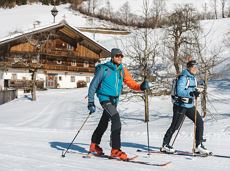
Cross-country trail with track for classic and free-style (skating)
Langlaufen
Normaal
0,5 km
10 Hoogtemeters

A unique hike to the highest mountain hut in the Wilder Kaiser region featuring a panoramic view.
Hiking starting point Going center (former tourist information Going) (764 m)
Hiking starting point Going center (former tourist information Going) (764 m)
Wandelen
Normaal
6:00 u
14,0 km
890 Hoogtemeters

A leisurely circular trail along the sunny side of Ellmau. This is a lovely walk along the picturesque Kaiserloipe with views of the majestic mountains. An easy hike for the whole family.
Hiking starting point Tourist Info, Ellmau (800 m)
Hiking starting point Tourist Info, Ellmau (800 m)
Wandelen
Gemakkelijk
2:00 u
5,8 km
50 Hoogtemeters

Beautiful circular walk around the frozen Lake Hinterstein.
Hiking starting point Seestüberl, Scheffau (890 m)
Hiking starting point Seestüberl, Scheffau (890 m)
Wandelen
Gemakkelijk
2:00 u
5,7 km
70 Hoogtemeters

Beautiful, Alpine sport climbing with consistent difficulty.
Alpine klimroutes

Historical route pleasant to walk for everyone.
Hiking starting point Tourist Info, Söll (689 m)
Hiking starting point Tourist Info, Söll (689 m)
Wandelen
Gemakkelijk
1:00 u
3,0 km
40 Hoogtemeters

Dizzying experience via snack stations to the waterfall via unmanaged alpine pastures to the Hexenwasser. Return to the valley by cable car or on foot.
Hiking starting point Bergbahn, Söll (725 m)
Hiking starting point Bergbahn, Söll (725 m)
Wandelen
Normaal
2:00 u
5,6 km
500 Hoogtemeters

Picturesque circular route on the sunny side of Going in unspoilt natural surroundings through snow-covered fields offering wonderful views of Going and the Wilder Kaiser region.
Hiking starting point Going center (former tourist information Going) (764 m)
Hiking starting point Going center (former tourist information Going) (764 m)
Wandelen
Gemakkelijk
1:45 u
4,8 km
80 Hoogtemeters

Picture-book cross-country skiing through the farm village with the mountain very close.
Hiking starting point Going Center (former Tourist informatin Going)
Hiking starting point Going Center (former Tourist informatin Going)
Langlaufen
Gemakkelijk
3,9 km
60 Hoogtemeters

More than 190 sport climbing routes, difficulty levels 3 to 9a+
Sportklimmen
Family-friendly, leisurely circular hike around the Astberg mountain
Astberg mountain station, Going (1.251 m)
Astberg mountain station, Going (1.251 m)
Wandelen
Gemakkelijk
0:30 u
1,5 km
80 Hoogtemeters

The largest bouldering hall in the Tirolean Unterland region.
Kletterhalle