


 Deutsch
 English
Ellmau circuit
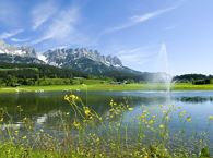
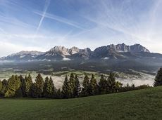
A beautiful easy hike at the foot of the Wilder Kaiser
Hiking starting point Tourist Info, Ellmau (800 m)
Hiking starting point Tourist Info, Ellmau (800 m)
Wandelen
Gemakkelijk
1:45 u
5,9 km
60 Hoogtemeters
De door u opgevraagde pagina is niet beschikbaar. U bent welkom om een nieuwe zoekopdracht op deze pagina te starten.
A beautiful easy hike at the foot of the Wilder Kaiser
Hiking starting point Tourist Info, Ellmau (800 m)
Hiking starting point Tourist Info, Ellmau (800 m)
Wandelen
Gemakkelijk
1:45 u
5,9 km
60 Hoogtemeters
Comfortable winter round with a magnificent view of the Hohe Salve.
Mountain station gondola Hexenwasser, Söll (1,150 m)
Mountain station gondola Hexenwasser, Söll (1,150 m)
Wandelen
Gemakkelijk
0:45 u
1,8 km
50 Hoogtemeters

Demanding mountain tour to the Kleines Törl pass, the little "brother" of the Ellmauer Tor in the Ostkaiser.
Hiking starting point Tannbichl, Going (855 m)
Hiking starting point Tannbichl, Going (855 m)
Wandelen
Moeilijk
8:00 u
12,0 km
1260 Hoogtemeters

Ellmau village park - Hartkaiserbahn valley station - Bergschenke - Rübezahlalm - Jägerhütte - Hartkaiser summit station
Hiking starting point Tourist Info, Ellmau (800 m)
Hartkaiser summit station, Ellmau (1,555 m)
Hardlopen
Normaal
8,2 km
720 Hoogtemeters

Kaindlhütte - Bettlersteig - Anton-Karg-Haus - Hans-Berger-Haus - Stripsenjochhaus
Hintersteiner See, Scheffau (889 m)
Stripsenjochhaus, St. Johann in Tirol (1,577 m)
Wandelen
Normaal
5:00 u
9,3 km
840 Hoogtemeters

A tour of the main filming locations of the TV series “Der Bergdoktor” (The Mountain Doctor) in Ellmau and Going, with a refreshment stop at the inn used during filming
Hiking starting point Tourist Info, Ellmau (800 m)
Hiking starting point Tourist Info, Ellmau (800 m)
Wandelen
Gemakkelijk
4:15 u
11,4 km
180 Hoogtemeters

Along with the Murmeltierfelsen and Gamsfelsen, there are a total of 17 climbing routes of difficulty levels 3 to 6b+ near the Gaudeamushütte mountain hut.
Sportklimmen

A tour for experienced bikers in the Kaiser's Alpine pasture area.
Community Hall, Scheffau (740 m)
Community Hall, Scheffau (740 m)
Fietsen
Moeilijk
21,3 km
690 Hoogtemeters

Two very demanding, fantastic lookout peaks on the Wilder Kaiser, which are not to be underestimated.
Hiking starting point Wegscheid, Scheffau (883 m)
Hiking starting point Wegscheid, Scheffau (883 m)
Wandelen
Moeilijk
9:00 u
11,0 km
1440 Hoogtemeters
A gentle walk to ancient farmsteads with a refreshment stop in a welcoming inn.
Hiking starting point Tourist Info, Scheffau (738 m)
Hiking starting point Tourist Info, Scheffau (738 m)
Wandelen
Gemakkelijk
1:30 u
3,8 km
80 Hoogtemeters

Going church square - Bergdoktor practice Ellmau and Gruberhof Söll. This e-bike tour gives you a chance to enjoy the magnificent mountain panorama at the foot of the Wilder Kaiser and takes you past the three main filming locations of the “Der Bergdoktor” (The Mountain Doctor) TV series.
Going church square
Going church square
Fietsen
Normaal
51,0 km
990 Hoogtemeters

Going, Hüttling - Schleierwasserfall - Obere Regalm - Baumgartenköpfl (Bergsteigergrab) - Gaudeamushütte - Ellmauer Tor - Hintere Goinger Halt - Jubiläumssteig - Gruttenhütte - Kaiser-Hochalm - Steiner-Hochalm - Hinterschießling Alm - Rehbachklamm - Scheffau, Dorf
Hiking starting point Hüttling, Going (820 m)
Scheffau village (738 m)
Wandelen
Moeilijk
14:00 u
24,6 km
2060 Hoogtemeters

Stripsenjochhaus - Griesner Alm - Griesenau
Stripsenjochhaus (1,577 m)
Griesenau, Kirchdorf (719 m)
Wandelen
Normaal
3:00 u
7,9 km

Bike tour to the idyllically situated Obere Regalm with a magnificent view.
Tourist Info, Going (764 m)
Tourist Info, Going (764 m)
Fietsen
Normaal
7,3 km
580 Hoogtemeters

A scenic circuit past Gieringer Weiher pond, Schwarzsee lake and Going bathing lake.
Tourist Info, Going (764 m)
Tourist Info, Going (764 m)
Fietsen
Normaal
40,1 km
460 Hoogtemeters

Crystal-clear mountain lake and magnificent views of the Wilder Kaiser’s western summits
Hintersteiner See, Scheffau (890 m)
Hintersteiner See, Scheffau (890 m)
Wandelen
Gemakkelijk
1:30 u
5,2 km
130 Hoogtemeters

Difficult piste tour via the downhill, route no. 40a to Hochsöll Hexenwasser mountain station & further on via the Keat downhill route no. 43 to the Keat alpine pastures.
Cable Car Söll, ski touring car park
Mountain station, Hexenwasser gondola or Keat Almen
Skitocht
Moeilijk
1:30 u
4,0 km
762 Hoogtemeters

The most adventurous route to the highest hut on the Wilder Kaiser.
Wochenbrunner Alm, Ellmau (1,085 m)
Wochenbrunner Alm, Ellmau (1,085 m)
Wandelen
Normaal
3:15 u
5,5 km
550 Hoogtemeters

A running circuit from Scheffau towards Ellmau via the Auwald district.
Starting point Scheffau Tourist Information Office (752 m)
Starting point Scheffau Tourist Information Office (752 m)
Hardlopen
Gemakkelijk
7,7 km
180 Hoogtemeters

Family-friendly, leisurely circular hike around the Astberg mountain
Astberg mountain station, Going (1.251 m)
Astberg mountain station, Going (1.251 m)
Wandelen
Gemakkelijk
0:30 u
1,5 km
80 Hoogtemeters

Nice circular hike through Going with visits to numerous chapels.
Hiking starting point Going center (former tourist information Going) (764 m)
Hiking starting point Going center (former tourist information Going) (764 m)
Wandelen
Gemakkelijk
2:45 u
9,3 km
210 Hoogtemeters

The Kitzbüheler Horn Via Ferrata offers a Magnificent Climbing Adventure for Less Experienced Climbers. Enjoy Spectacular Views and Adrenaline Rushes while being Safe and Secure throughout Your Journey.
Via ferrata
Gasteig – Wilder-Kaiser-Steig – Ursulablick – Gscheuerkopf – Graspoint-Hochalm – Graspoint-Niederalm – Going, Hüttling
Gasteig (750 m)
Hiking starting point Hüttling, Going (820 m)
Wandelen
Normaal
5:15 u
10,8 km
840 Hoogtemeters

Ellmau Tourist Information Office - golf course - Wochenbrunner Alm
Tourist Information Office, Ellmau (800 m)
Wochenbrunner Alm, Ellmau (1,085 m)
Fietsen
Normaal
4,8 km
260 Hoogtemeters

Pleasant circular hiking trail through forests and meadows to the romantically situated moor lake.
Hiking starting point Franzlhof, Söll (703 m)
Hiking starting point Franzlhof, Söll (703 m)
Wandelen
Normaal
2:00 u
5,7 km
240 Hoogtemeters

Up for a wild witch’s ride? Day and night: off you go!
Cable car valley station, Söll (725 m)
Cable car valley station, Söll (725 m)
Rodelen
Normaal
3,0 km
Circular cycling route for leisure bikers between the four villages of the Kaiser region.
anywhere along the tour
anywhere along the tour
Fietsen
Normaal
38,5 km
550 Hoogtemeters

2 villages - you fancy quiete and a very rural athmosphere - Scheffau is the place to go, or, you opt for a great variety of gastronomy and restaurants - then Söll is good to go. No matter how, your decision is always superb. The ski hiking route is purely flat, which also means it's great for everybody.
restaurant Oberstegen, Söll
village, Scheffau
Langlaufen
Gemakkelijk
1,4 km
15 Hoogtemeters

Hike to the Gaudeamushütte mountain hut by the Wilder Kaiser
Wochenbrunner Alm, Ellmau (1,085 m)
Gaudeamushütte, Going (1,263 m)
Wandelen
Gemakkelijk
0:35 u
1,3 km
200 Hoogtemeters

The heart of the tour is the deep, wonderful-to-climb chimney, which lends the tour an Alpine character.
Alpine klimroutes

An adventure hike from Ellmau village centre to the Wochenbrunner Alm mountain hut from where you can enjoy stunning views and the Ellmau Stone Circle.
Hiking starting point Tourist Info, Ellmau (800 m)
Hiking starting point Tourist Info, Ellmau (800 m)
Wandelen
Gemakkelijk
4:30 u
13,5 km
530 Hoogtemeters

Easy snowshoe hike at the foot of the Wilder Kaiser.
Postbus stop Dorf/Bauhof, Ellmau
Postbus stop Dorf/Bauhof, Ellmau
Wandelen
Gemakkelijk
0:40 u
1,3 km
10 Hoogtemeters
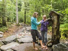
Refreshing walk through the Kneipp facilities and adventures in the Rehbachklamm gorge
Hiking starting point Tourist Info, Scheffau (738 m)
Hiking starting point Tourist Info, Scheffau (738 m)
Wandelen
Normaal
2:00 u
7,1 km
330 Hoogtemeters

Explore the sunny foot of the Pölven mountain.
Langlaufen
Gemakkelijk
0,9 km

More than 190 sport climbing routes, difficulty levels 3 to 9a+
Sportklimmen

Culinary tour on the Hohe Salve
Bergstation Rabennest (1.150 m)
Bergstation Rabennest (1.150 m)
Wandelen
Gemakkelijk
1:30 u
4,0 km
160 Hoogtemeters

From Going to the Astberg with a small altitude loop & impressive panoramic view.
Hiking starting point Going center (former tourist information Going) (764 m)
Hiking starting point Going center (former tourist information Going) (764 m)
Wandelen
Gemakkelijk
3:30 u
8,6 km
560 Hoogtemeters

Via ferrata

Approaching from the north, this trail leads through the Steinerne Rinne to the majestic Ellmauer Tor.
Griesner Alm, 988 m
Wochenbrunner Alm, Ellmau (1,085 m)
Wandelen
Moeilijk
5:45 u
8,1 km
1060 Hoogtemeters
Sturdy boots will help keep your ankles and feet happy on this hike, full of the best things Tirol has to offer: well-maintained trails, wildflowers galore and waterfalls beckon the adventurous hiker ready for a strenuous climb with breathtaking views of lofty Wilder Kaiser Mountain Range as your reward. The nature reserve’s landscape will win you over with its diverse beauty. The pasture regions are covered with soft grassy meadows, and hikers are greeted by lofty Wilder Kaiser Mountain Range with rugged Maukspitze, Ackerlspitze, Regalpspitze and Törlspitze Peaks, all “Two-Thousanders” that average 2,000 metres altitude. Trailhead is Rummlerhof Inn, northwest of the village centre of St. Johann. After a successful first segment, why not take a rest at Gaudeamus Hut, raise your glass and sing: “Gaudeamus igitur – Let us be happy!” For many hikers this is far enough, contentment has already set in. Adventurous souls continue on the trail that works its way up across Klamml Gorge to Grutten Hut, which entails another 400 metres of climbing.
Rummlerhof, St.Johann in Tirol
Gaudeamushütte
Wandelen
Normaal
5:00 u
13,0 km
1060 Hoogtemeters