


 Deutsch
 English
Via ferrata Himmel & Henne Fieberbrunn
Gesloten
Via ferrata
De door u opgevraagde pagina is niet beschikbaar. U bent welkom om een nieuwe zoekopdracht op deze pagina te starten.
Via ferrata
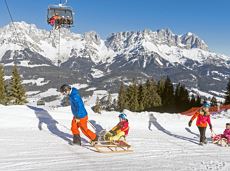
A mountain with lots of tobogganing options and good refreshment stops.
Astbergbahn Talstation, Going (805 m)
Astbergbahn Talstation, Going (805 m)
Rodelen
Normaal
3,2 km
Alpine pasture circular hiking route with a breathtaking view over Scheffau!
Hiking starting point Tourist Info, Scheffau (738 m)
Hiking starting point Tourist Info, Scheffau (738 m)
Wandelen
Normaal
5:15 u
12,9 km
800 Hoogtemeters

Enjoy unspoilt views of the Sölllandl region from snow-covered fields.
Hiking starting point Franzlhof, Söll (703 m)
Hiking starting point Franzlhof, Söll (703 m)
Wandelen
Gemakkelijk
2:15 u
5,8 km
100 Hoogtemeters

Gentle walking or running course in Ellmau
Hiking starting point Tourist Info, Ellmau (800 m)
Hiking starting point Tourist Info, Ellmau (800 m)
Hardlopen
Gemakkelijk
0:20 u
3,0 km
54 Hoogtemeters

Savour the wonder of the winter landscape – experience the winter magic for yourself by crunching through the pristine snow with your snowshoes. Enjoy unique impressions and experiences as you explore the white winter splendour and take in the spectacular view over the surrounding mountain scenery.
Church square, Going (769 m)
Church square, Going (769 m)
Wandelen
Gemakkelijk
1:30 u
2,9 km
110 Hoogtemeters
Ellmau hiking info point - Wimm - Riesen - Biedringer Alm - Biedringer Bauernhöfe - Ellmauer Kaiserbad - Ellmau hiking info point
Hiking starting point Tourist Info, Ellmau (800 m)
Hiking starting point Tourist Info, Ellmau (800 m)
Hardlopen
Gemakkelijk
9,8 km
400 Hoogtemeters

It’s up and away to a popular inn in Söll.
Hiking starting point Tourist Info, Söll (689 m)
Stallhäusl, Söll (972 m)
Fietsen
Normaal
6,1 km
310 Hoogtemeters

Crystal-clear mountain lake and magnificent views of the Wilder Kaiser’s western summits
Hintersteiner See, Scheffau (890 m)
Hintersteiner See, Scheffau (890 m)
Wandelen
Gemakkelijk
1:30 u
5,2 km
130 Hoogtemeters
Hike to the Hexenwasser and get rewarded with a view.
Bergbahn valley station, Söll (724 m)
Bergbahn valley station, Söll (724 m)
Wandelen
Gemakkelijk
3:00 u
7,9 km
410 Hoogtemeters

The most adventurous route to the highest hut on the Wilder Kaiser.
Wochenbrunner Alm, Ellmau (1,085 m)
Wochenbrunner Alm, Ellmau (1,085 m)
Wandelen
Normaal
3:15 u
5,5 km
550 Hoogtemeters

Challenging adventure hike to the Ellmauer Tor
Hiking starting point Wochenbrunner Alm, Ellmau (1,085 m)
Ellmauer Tor, Ellmau (2,001 m)
Wandelen
Normaal
5:00 u
7,7 km
900 Hoogtemeters

A scenic circuit past Gieringer Weiher pond, Schwarzsee lake and Going bathing lake.
Tourist Info, Going (764 m)
Tourist Info, Going (764 m)
Fietsen
Normaal
40,1 km
460 Hoogtemeters

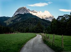
A picturesque mountain hike that leads from the turquoise waters of the most beautiful mountain lake in Tirol up to the rustic Alpine village.
Hiking starting point Seestüberl, Scheffau (890 m)
Hiking starting point Seestüberl, Scheffau (890 m)
Wandelen
Normaal
3:15 u
9,3 km
360 Hoogtemeters

Family hike on Austria’s longest sculpture trail
Hartkaiser summit station, Ellmau (1,555 m)
Rübezahl-Alm, Ellmau (1,174 m)
Wandelen
Normaal
1:00 u
2,5 km
50 Hoogtemeters

Experience impressive low and panoramic views in the unique rocky scenery of the legendary "Wild Castle", as this area is known according to legend thanks to its many turrets, peaks, hollows and balconies.
Wochenbrunner Alm, Ellmau (1.085 m)
Wochenbrunner Alm, Ellmau (1.085 m)
Wandelen
Moeilijk
3:45 u
6,3 km
630 Hoogtemeters
Quietness, strength and with easy breathing steadily closer to the Wilder Kaiser. You can return on foot or by bus.
Hiking starting point Bergbahn, Söll (724 m)
Gasthof Bocking, Söll (665 m)
Wandelen
Gemakkelijk
1:45 u
5,5 km
100 Hoogtemeters

Pure adrenaline is the motto of the Pölven trail on the third day of the Tour de Tirol
Hiking starting point Tourist Info, Söll (689 m)
Hiking starting point Tourist Info, Söll (689 m)
Hardlopen
Normaal
22,8 km
1110 Hoogtemeters

An extensive exploration of “Moor & more”. The puzzle tour in the Wilder Kaiser forest is sure to be lots of fun, even for older children.
Hiking starting point Hüttling, Going (820 m)
Hiking starting point Hüttling, Going (820 m)
Wandelen
Gemakkelijk
3:00 u
8,0 km
380 Hoogtemeters

Following the Stampfangerbach stream on the way to Filzalm lake
Hiking starting point Bergbahn, Söll (725 m)
Hiking starting point Bergbahn, Söll (725 m)
Wandelen
Normaal
3:15 u
9,0 km
620 Hoogtemeters

Peace and strength, slow down and take a deep breath.
Ahornsee car park, Söll (693 m)
Ahornsee car park, Söll (693 m)
Wandelen
Normaal
4:45 u
12,0 km
220 Hoogtemeters

This easy family hike takes you via the Bergdoktorhaus to the Berggasthof Hochschwendt mountain inn.
Wanderstartplatz Tourist Info, Ellmau (800m)
Wanderstartplatz Tourist Info, Ellmau (800m)
Wandelen
Gemakkelijk
2:45 u
8,7 km
270 Hoogtemeters

From Hochsöll (Hexenwasser theme park) and Filzalmsee lake to Brixen im Thale.
Hexenwasser theme park Söll Hohe Salve
Brixen im Thale valley station
Fietsen
Normaal
9,3 km
200 Hoogtemeters

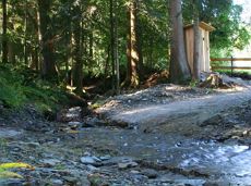
Atmospheric forest walk along the snow-white creek.
Hiking starting point Tourist Info, Scheffau (738 m)
Hiking starting point Tourist Info, Scheffau (738 m)
Wandelen
Normaal
2:00 u
4,2 km
160 Hoogtemeters

An adventure hike from Ellmau village centre to the Wochenbrunner Alm mountain hut from where you can enjoy stunning views and the Ellmau Stone Circle.
Hiking starting point Tourist Info, Ellmau (800 m)
Hiking starting point Tourist Info, Ellmau (800 m)
Wandelen
Gemakkelijk
4:30 u
13,5 km
530 Hoogtemeters

Alpine klimroutes

Intermediate circular hike with breathtaking views on the surrounding mountains. Attention: Trail no 828 is closed due to danger of falling rocks. Detour via path no. 816 and 827 via the Obere Regalm to the Baumgartenköpfl.
Hiking starting point Tannbichl, Going (857 m)
Hiking starting point Tannbichl, Going (857 m)
Wandelen
Normaal
4:45 u
9,8 km
760 Hoogtemeters

A tour of the main filming locations of the TV series “Der Bergdoktor” (The Mountain Doctor) in Ellmau and Going, with a refreshment stop at the inn used during filming
Hiking info point, Tourist Info Ellmau (800 m)
Hiking info point, Tourist Info Ellmau (800 m)
Wandelen
Gemakkelijk
3:15 u
11,4 km
180 Hoogtemeters

This well-secured sport climbing route features interesting lines in prime rock.
Alpine klimroutes
Gasteig – Wilder-Kaiser-Steig – Ursulablick – Gscheuerkopf – Graspoint-Hochalm – Graspoint-Niederalm – Going, Hüttling
Gasteig (750 m)
Hiking starting point Hüttling, Going (820 m)
Wandelen
Normaal
5:15 u
10,8 km
840 Hoogtemeters

Enjoy winter silence and an imperial panorama in Söll.
parking area Ahornsee, Söll (693 m)
parking area Ahornsee, Söll (693 m)
Langlaufen
Normaal
5,3 km
80 Hoogtemeters

Energy trail with seven stations offering refreshing and relaxing experiences.
Hiking starting point Tourist Info, Scheffau (738 m)
Hiking starting point Tourist Info, Scheffau (738 m)
Wandelen
Gemakkelijk
0:45 u
2,3 km
70 Hoogtemeters

Alpine klimroutes

Enjoy snowy forests and nature in winter.
Hiking starting point Tourist Info, Scheffau (738 m)
Hiking starting point Tourist Info, Scheffau (738 m)
Wandelen
Gemakkelijk
1:45 u
3,8 km
170 Hoogtemeters

Picture-postcard panoramic scenery to Hintersteiner See lake, a natural gem.
Villag Center, Söll (689 m)
Hintersteiner See Lake, Scheffau (889 m)
Fietsen
Normaal
9,4 km
430 Hoogtemeters

Hike from the centre of Ellmau, along trail no. 14, through the "Spatlahner gorge" up to the Wochenbrunner Alm.
Hiking starting point Tourist Information Office, Ellmau (800 m)
Hiking starting point Tourist Information Office, Ellmau (800 m)
Wandelen
Gemakkelijk
1:30 u
4,4 km
285 Hoogtemeters

This 3-part Via Ferrata features a rope bridge and an extremely difficult exit option.
Via ferrata

The Kitzbüheler Horn Via Ferrata offers a Magnificent Climbing Adventure for Less Experienced Climbers. Enjoy Spectacular Views and Adrenaline Rushes while being Safe and Secure throughout Your Journey.
Via ferrata

Hartkaiserbahn summit station - Ellmis Zauberwald - Tanzbodensee lake - Hartkaiserbahn summit station
Hartkaiser summit station, Ellmau (1,555 m)
Hartkaiser summit station, Ellmau (1,555 m)
Hardlopen
Gemakkelijk
3,4 km
120 Hoogtemeters

A unique hike to the highest mountain hut in the Wilder Kaiser region featuring a panoramic view.
Hiking starting point Going center (former tourist information Going) (764 m)
Hiking starting point Going center (former tourist information Going) (764 m)
Wandelen
Normaal
6:00 u
14,0 km
890 Hoogtemeters