


 Deutsch
 English
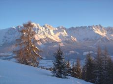
Round the Achleitberg mountain

A hike on varied paths around the Achleitberg.
Hiking starting point Tourist Info, Scheffau (738 m)
Hiking starting point Tourist Info, Scheffau (738 m)
Wandelen
Normaal
5:45 u
18,0 km
540 Hoogtemeters
De door u opgevraagde pagina is niet beschikbaar. U bent welkom om een nieuwe zoekopdracht op deze pagina te starten.
A hike on varied paths around the Achleitberg.
Hiking starting point Tourist Info, Scheffau (738 m)
Hiking starting point Tourist Info, Scheffau (738 m)
Wandelen
Normaal
5:45 u
18,0 km
540 Hoogtemeters

On the north side up to the Ellmauer Halt summit 2,344 m.
Via ferrata

Alpine klimroutes

Old path - now renovated and featuring a pleasant series of ascents and descents.
Hiking starting point Bergbahn, Söll (725 m)
Hiking starting point Bergbahn, Söll (725 m)
Wandelen
Normaal
4:30 u
13,5 km
470 Hoogtemeters

Explore the sunny foot of the Pölven mountain.
Hiking starting point Franzlhof, Söll (703 m)
Hiking starting point Franzlhof, Söll (703 m)
Wandelen
Normaal
2:30 u
6,8 km
100 Hoogtemeters

The Anna Grotto is hidden in the middle of a forest at the very foot of the Wilder Kaiser.
Wochenbrunner Alm, Ellmau (1,085 m)
Wochenbrunner Alm, Ellmau (1,085 m)
Wandelen
Gemakkelijk
0:20 u
0,7 km
50 Hoogtemeters

The short via ferrata is ideal for beginners.
Via ferrata

Comfortable round with a magnificent view of the Hohe Salve.
Mountain station gondola Hexenwasser, Söll (1,150 m)
Mountain station gondola Hexenwasser, Söll (1,150 m)
Wandelen
Gemakkelijk
0:35 u
1,8 km
50 Hoogtemeters

Alpine klimroutes
Hike via four mountain huts Rübezahl-Alm, Jägerhütte and Hochschwendt.
Hiking starting point Tourist Info, Ellmau (800 m)
Hiking starting point Tourist Info, Ellmau (800 m)
Wandelen
Gemakkelijk
6:15 u
14,0 km
600 Hoogtemeters

Up for a wild witch’s ride? Day and night: off you go!
Cable car valley station, Söll (725 m)
Cable car valley station, Söll (725 m)
Rodelen
Normaal
3,0 km

A unique hike to the highest mountain hut in the Wilder Kaiser region featuring a panoramic view.
Hiking starting point Going center (former tourist information Going) (764 m)
Hiking starting point Going center (former tourist information Going) (764 m)
Wandelen
Normaal
6:00 u
14,0 km
890 Hoogtemeters

By bike through the culinary region Wilder Kaiser.
anywhere along the tour
anywhere along the tour
Fietsen
Normaal
38,3 km
560 Hoogtemeters

Calling bike fans of all ability levels! The Kaiser circular cycling route is an 80-kilometre bike route through the spectacular scenery of the Kaisergebirge mountain range. An excellent network of well-signposted trails (a mix of asphalt and gravel paths) leads past idyllic nature, breathtaking panoramas and cultural sights. For relaxing moments in between stages, cool lakes and local restaurants invite you to linger and enjoy.
anywhere along the tour
anywhere along the tour
Fietsen
Normaal
83,0 km
700 Hoogtemeters

Ellmau village park - Hartkaiserbahn valley station - Bergschenke - Rübezahlalm - Jägerhütte - Hartkaiser summit station
Hiking starting point Tourist Info, Ellmau (800 m)
Hartkaiser summit station, Ellmau (1,555 m)
Hardlopen
Normaal
8,2 km
720 Hoogtemeters

This pleasant circular walk takes you to Söll’s war memorial in a beautiful section of forest.
Hiking starting point Tourist Info, Söll (689 m)
Hiking starting point Tourist Info, Söll (689 m)
Wandelen
Gemakkelijk
0:30 u
2,1 km
10 Hoogtemeters

Atmospheric forest walk along the snow-white creek.
Hiking starting point Tourist Info, Scheffau (738 m)
Hiking starting point Tourist Info, Scheffau (738 m)
Wandelen
Normaal
2:00 u
4,2 km
160 Hoogtemeters

Alpine klimroutes

Kaindlhütte - Bettlersteig - Anton-Karg-Haus - Hans-Berger-Haus - Stripsenjochhaus
Hintersteiner See, Scheffau (889 m)
Stripsenjochhaus, St. Johann in Tirol (1,577 m)
Wandelen
Normaal
5:00 u
9,3 km
840 Hoogtemeters

The varied loop takes you on leisurely valley cycle paths as well as a mountain evaluation on the MTB routes 265 and 350 once around the Hohe Salve lookout mountain.
Tourismus Info, Söll
Tour
Fietsen
Normaal
36,5 km
880 Hoogtemeters

Following the Stampfangerbach stream on the way to Filzalm lake
Hiking starting point Bergbahn, Söll (725 m)
Hiking starting point Bergbahn, Söll (725 m)
Wandelen
Normaal
3:15 u
9,0 km
620 Hoogtemeters

Peace and strength, slow down and take a deep breath.
Ahornsee car park, Söll (693 m)
Ahornsee car park, Söll (693 m)
Wandelen
Normaal
4:45 u
12,0 km
220 Hoogtemeters

A picturesque mountain hike that leads from the turquoise waters of the most beautiful mountain lake in Tirol up to the rustic Alpine village.
Hiking starting point Seestüberl, Scheffau (890 m)
Hiking starting point Seestüberl, Scheffau (890 m)
Wandelen
Normaal
3:15 u
9,3 km
360 Hoogtemeters

Stripsenjochhaus – Stripsenkopf – Feldberg – Scheibenbichlalmen – Griesenau – Gasteig
Stripsenjochhaus, St. Johann in Tirol (1,577 m)
Gasteig (750 m)
Wandelen
Normaal
6:30 u
16,1 km
640 Hoogtemeters

This tour is rich in variety and includes slabs, water grooves, as well as a strong overhang and a traverse with an undercling passage.
Alpine klimroutes
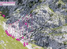
31 routes, including 14 multi-pitch.
Sportklimmen

Hike to the Gruttenhütte with great views to the Ellmauer Halt and the entire region.
Hiking starting point Tourist Info, Scheffau (738 m)
Gruttenhütte, Ellmau (1,620 m)
Wandelen
Normaal
6:30 u
16,4 km
990 Hoogtemeters

Enjoy the scenic area of the Hohe Salve where the Söll waters originate.
Exit Keat chairlift, Söll (1,533 m)
Exit Keat chairlift, Söll (1,533 m)
Wandelen
Normaal
3:45 u
10,3 km
530 Hoogtemeters

Stripsenjochhaus - Griesner Alm - Griesenau
Stripsenjochhaus (1,577 m)
Griesenau, Kirchdorf (719 m)
Wandelen
Normaal
3:00 u
7,9 km

Exciting adventure stations for family tobogganing on the Hohe Salve.
Cable car valley station, Söll (725 m)
Cable car valley station, Söll (725 m)
Rodelen
Gemakkelijk
4,0 km
Alpine pasture circular hiking route with a breathtaking view over Scheffau!
Hiking starting point Tourist Info, Scheffau (738 m)
Hiking starting point Tourist Info, Scheffau (738 m)
Wandelen
Normaal
5:15 u
12,9 km
800 Hoogtemeters

Nice circular hike through Going with visits to numerous chapels.
Hiking starting point Going center (former tourist information Going) (764 m)
Hiking starting point Going center (former tourist information Going) (764 m)
Wandelen
Gemakkelijk
2:45 u
9,3 km
210 Hoogtemeters

Over snow-covered meadows along the Goinger Sonnseite
Bathing lake, Going (742 m)
Bathing lake, Going (742 m)
Wandelen
Gemakkelijk
1:30 u
3,9 km
60 Hoogtemeters

Panoramic circular walk in the Wilder Kaiser leading to the highest mountain hut in the region.
Hiking starting point Tourist Info, Ellmau (800 m)
Hiking starting point Tourist Info, Ellmau (800 m)
Wandelen
Normaal
6:00 u
15,7 km
870 Hoogtemeters

The panoramic Scheffauer is the last high peak in the west at 2,111 m above sea level.
Hiking starting point Bärnstatt, Scheffau (920 m)
Hiking starting point Bärnstatt, Scheffau (920 m)
Wandelen
Moeilijk
7:00 u
7,9 km
1180 Hoogtemeters

A run during which you can enjoy peace and quiet in the great outdoors.
Starting point Scheffau Tourist Information Office (752 m)
Starting point Scheffau Tourist Information Office (752 m)
Hardlopen
Normaal
6,1 km
260 Hoogtemeters
An ascent that is rewarded with refreshments. Back to the valley with the toboggan, the lift or on foot.
Village centre, Ellmau (800 m)
Astbergbahn, Going (804 m)
Wandelen
Gemakkelijk
2:45 u
5,8 km
460 Hoogtemeters

Enjoy unique panoramic views of the impressive mountains from the Biedringer Platte plateau.
Hiking starting point Tourist Info, Ellmau (800 m)
Hiking starting point Tourist Info, Ellmau (800 m)
Wandelen
Gemakkelijk
4:15 u
12,6 km
470 Hoogtemeters

Off the beaten track up to the Köpfing farmhouse. “Der Bergdoktor” (The Mountain Doctor) is a famous German-Austrian TV series, which is produced in the Wilder Kaiser region.
Bergdoktor parking lot, Söll
Bergdoktor parking lot, Söll
Wandelen
Gemakkelijk
3:00 u
8,4 km
370 Hoogtemeters

Turnoff to Granderalm – Schleier Waterfall – Going, Hüttling
First turnoff after the Granderalm
Hiking starting point Hüttling, Going (820 m)
Wandelen
Normaal
2:00 u
3,1 km
40 Hoogtemeters