Hoppala, route niet gevonden

De door u opgevraagde pagina is niet beschikbaar. U bent welkom om een nieuwe zoekopdracht op deze pagina te starten.

0 Routes & tochten

Kaiser circular cycling route

Kaiser circular cycling route

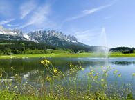
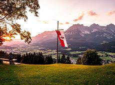
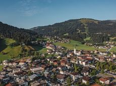
Calling bike fans of all ability levels! The Kaiser circular cycling route is an 80-kilometre bike route through the spectacular scenery of the Kaisergebirge mountain range. An excellent network of well-signposted trails (a mix of asphalt and gravel paths) leads past idyllic nature, breathtaking panoramas and cultural sights. For relaxing moments in between stages, cool lakes and local restaurants invite you to linger and enjoy.

anywhere along the tour

anywhere along the tour

Fietsen

Normaal

83,0 km

700 Hoogtemeters

Schwendt circuit

Schwendt circuit
Schwendt circuit
Schwendt circuit

Pleasant hike through forests and across meadows to the sunny plateau of Going and back

Hiking starting point Going center (former tourist information Going) (764 m)

Hiking starting point Going center (former tourist information Going) (764 m)

Wandelen

Gemakkelijk

1:15 u

4,1 km

70 Hoogtemeters

Schattseitloipe

Schattseitloipe
Schattseitloipe
Schattseitloipe

Enjoy winter silence and an imperial panorama in Söll.

parking area Ahornsee, Söll (693 m)

parking area Ahornsee, Söll (693 m)

Langlaufen

Normaal

5,3 km

80 Hoogtemeters

Ellmau circuit

Ellmau circuit
Ellmau circuit
Ellmau circuit

A beautiful easy hike at the foot of the Wilder Kaiser

Hiking starting point Tourist Info, Ellmau (800 m)

Hiking starting point Tourist Info, Ellmau (800 m)

Wandelen

Gemakkelijk

1:45 u

5,9 km

60 Hoogtemeters

Asten circuit

Asten circuit
Asten circuit
Asten circuit

From Going to the Astberg with a small altitude loop & impressive panoramic view.

Hiking starting point Going center (former tourist information Going) (764 m)

Hiking starting point Going center (former tourist information Going) (764 m)

Wandelen

Gemakkelijk

3:30 u

8,6 km

560 Hoogtemeters

Winter-Rehbach tour

Winter-Rehbach tour
Winter-Rehbach tour
Winter-Rehbach tour

Enjoy snowy forests and nature in winter.

Hiking starting point Tourist Info, Scheffau (738 m)

Hiking starting point Tourist Info, Scheffau (738 m)

Wandelen

Gemakkelijk

1:45 u

3,8 km

170 Hoogtemeters

Ackerlhütten circular hike

Ackerlhütten circular hike

Intermediate circular hike with breathtaking views on the surrounding mountains. Attention: Trail no 828 is closed due to danger of falling rocks. Detour via path no. 816 and 827 via the Obere Regalm to the Baumgartenköpfl.

Hiking starting point Tannbichl, Going (857 m)

Hiking starting point Tannbichl, Going (857 m)

Wandelen

Normaal

4:45 u

9,8 km

760 Hoogtemeters

Ellmau village tour

Ellmau village tour
Ellmau village tour
Ellmau village tour

Postkarten circuit Ellmau Ellmau hiking info point – Kapellenpark – Marienkapelle – Ellmau Parish Church

Hiking starting point Tourist Info, Ellmau (800 m)

Hiking starting point Tourist Info, Ellmau (800 m)

Wandelen

Gemakkelijk

0:25 u

1,3 km

40 Hoogtemeters

Söller village tour

Söller village tour
Söller village tour
Söller village tour

Looping the village of Söll, the sight seeing hike!

Hiking starting point Tourist Info, Söll (689 m)

Hiking starting point Tourist Info, Söll (689 m)

Wandelen

Gemakkelijk

1:00 u

3,7 km

50 Hoogtemeters

Rehbach tour

Rehbach tour
Rehbach tour
Rehbach tour

Exciting round trip for adults and children through the Rehbach gorge.

Hiking starting point Tourist Info, Scheffau (738 m)

Hiking starting point Tourist Info, Scheffau (738 m)

Wandelen

Normaal

2:00 u

5,5 km

280 Hoogtemeters

Pölven circular route

Pölven circular route

A circuit around the mountain that the locals love for its great view.

Hiking starting point Franzlhof, Söll (703 m)

Hiking starting point Franzlhof, Söll (703 m)

Wandelen

Normaal

6:00 u

17,8 km

670 Hoogtemeters

Bergdoktor tour of Ellmau

Bergdoktor tour of Ellmau

A tour of the main filming locations of the TV series “Der Bergdoktor” (The Mountain Doctor) in Ellmau, with a refreshment stop at the inn used during filming

Hiking starting point Tourist Info, Ellmau (798 m)

Hiking starting point Tourist Info, Ellmau (798 m)

Wandelen

Gemakkelijk

2:15 u

7,5 km

200 Hoogtemeters

War memorial circular route

War memorial circular route

This pleasant circular walk takes you to Söll’s war memorial in a beautiful section of forest.

Hiking starting point Tourist Info, Söll (689 m)

Hiking starting point Tourist Info, Söll (689 m)

Wandelen

Gemakkelijk

0:30 u

2,1 km

10 Hoogtemeters

Kleines Törl

Kleines Törl
Kleines Törl
Kleines Törl

Demanding mountain tour to the Kleines Törl pass, the little "brother" of the Ellmauer Tor in the Ostkaiser.

Hiking starting point Tannbichl, Going (855 m)

Hiking starting point Tannbichl, Going (855 m)

Wandelen

Moeilijk

8:00 u

12,0 km

1260 Hoogtemeters

Kaiserkrone - around the Wilder Kaiser in 5 days

Kaiserkrone - around the Wilder Kaiser in 5 days

Wild and free - 5 days of hiking on old paths around the Wilder Kaiser The five-day hike from hut to hut is one of the most beautiful multi-day circular tours in Tirol. It takes mountain walkers along a route of around 58 kilometres, featuring ascents and descents with a difference in altitude of approximately 4,000 metres as they circle around the imposing Wilder Kaiser massif.

Hiking starting point Hüttling, Going (820 m)

Hiking starting point Hüttling, Going (820 m)

Wandelen

Normaal

27 u

57,7 km

4000 Hoogtemeters

Hartkaiserweg trail Ellmau

Hartkaiserweg trail Ellmau

Ellmau village park - Hartkaiserbahn valley station - Bergschenke - Rübezahlalm - Jägerhütte - Hartkaiser summit station

Hiking starting point Tourist Info, Ellmau (800 m)

Hartkaiser summit station, Ellmau (1,555 m)

Hardlopen

Normaal

8,2 km

720 Hoogtemeters

Ellmauer Halt summit tour

Ellmauer Halt summit tour

A demanding mountain tour with some ferrata passages up to the highest summit in the Wilder Kaiser (2,344 m).

Hiking starting point Wochenbrunner Alm, Ellmau (1,085 m)

Hiking starting point Wochenbrunner Alm, Ellmau (1,085 m)

Wandelen

Moeilijk

7:30 u

9,3 km

1250 Hoogtemeters

Hartkaiser circuit Ellmau

Hartkaiser circuit Ellmau

Hartkaiserbahn summit station - Ellmis Zauberwald - Tanzbodensee lake - Hartkaiserbahn summit station

Hartkaiser summit station, Ellmau (1,555 m)

Hartkaiser summit station, Ellmau (1,555 m)

Hardlopen

Gemakkelijk

3,4 km

120 Hoogtemeters

Kneipp circuit

Kneipp circuit
Kneipp circuit
Kneipp circuit

Energy trail with seven stations offering refreshing and relaxing experiences.

Hiking starting point Tourist Info, Scheffau (738 m)

Hiking starting point Tourist Info, Scheffau (738 m)

Wandelen

Gemakkelijk

0:45 u

2,3 km

70 Hoogtemeters

Bergdoktor tour of Ellmau & Going

Bergdoktor tour of Ellmau & Going

A tour of the main filming locations of the TV series “Der Bergdoktor” (The Mountain Doctor) in Ellmau and Going, with a refreshment stop at the inn used during filming

Hiking info point, Tourist Info Ellmau (800 m)

Hiking info point, Tourist Info Ellmau (800 m)

Wandelen

Gemakkelijk

3:15 u

11,4 km

180 Hoogtemeters

Piste tour route no. 2 - Söll

Piste tour route no. 2 - Söll
GeslotenPiste tour route no. 2 - Söll
Piste tour route no. 2 - Söll

Difficult piste tour via the downhill, route no. 40a to Hochsöll Hexenwasser mountain station & further on via the Keat downhill route no. 43 to the Keat alpine pastures.

Cable Car Söll, ski touring car park

Mountain station, Hexenwasser gondola or Keat Almen

Skitocht

Moeilijk

1:30 u

4,0 km

762 Hoogtemeters

Hike to Wochenbrunner Alm

Hike to Wochenbrunner Alm

Hike from the centre of Ellmau, along trail no. 14, through the "Spatlahner gorge" up to the Wochenbrunner Alm.

Hiking starting point Tourist Information Office, Ellmau (800 m)

Hiking starting point Tourist Information Office, Ellmau (800 m)

Wandelen

Gemakkelijk

1:30 u

4,4 km

285 Hoogtemeters

Path of reflection

Path of reflection
Path of reflection
Path of reflection

Leisurely path of reflection to the St. Anna chapel at Lengau

Parkplatz Liftstation Itter (655 m)

Lengauer Kapelle

Wandelen

Gemakkelijk

1:15 u

3,2 km

270 Hoogtemeters