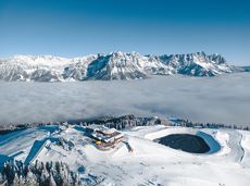
Hoppala, route niet gevonden

De door u opgevraagde pagina is niet beschikbaar. U bent welkom om een nieuwe zoekopdracht op deze pagina te starten.

Hoppala, route niet gevonden

De door u opgevraagde pagina is niet beschikbaar. U bent welkom om een nieuwe zoekopdracht op deze pagina te starten.

0 Routes & tochten

Via ferrata s'Schuastagangl Steinplatte

Via ferrata s'Schuastagangl Steinplatte
Via ferrata s'Schuastagangl SteinplatteOpen
Via ferrata s'Schuastagangl Steinplatte

Attention! There is an increased risk of slipping on the ascents and descents due to snow fields! Walk at your own risk! The classic on the Steinplatte Waidring was rehabilitated in June 2023 and is a treat for via ferrata fans! The via ferrata "s'Schuastagangl" (C/D) offers wonderful panoramic views, crisp ascents and unforgettable mountain moments. The varied tour leads through steep rock faces and slippery passages up to the summit of the Waidringer Steinplatte (1,848m). Strength for steeper ascents and courage for ladder passages and the "Knieschloderer" variant with airy steps and a rope bridge are required!

Via ferrata

Hike to Wochenbrunner Alm

Hike to Wochenbrunner Alm

Hike from the centre of Ellmau, along trail no. 14, through the "Spatlahner gorge" up to the Wochenbrunner Alm.

Hiking starting point Tourist Info, Ellmau (800 m)

Hiking starting point Tourist Info, Ellmau (800 m)

Wandelen

Gemakkelijk

1:30 u

4,4 km

285 Hoogtemeters

Hausberg trail (no. 8)

Hausberg trail (no. 8)

Hiking trail no. 8 to the Hausberg via the Marienkapelle (St Mary’s Chapel).

Hiking starting point Tourist Information Office, Ellmau (798 m)

Brenner Alm, Ellmau (1,236 m)

Wandelen

Gemakkelijk

3:00 u

7,5 km

440 Hoogtemeters

Hiking route Scheffau - Ellmau

Hiking route Scheffau - Ellmau
Hiking route Scheffau - Ellmauaanbevolen
Hiking route Scheffau - Ellmau

Hike along the sunny side along field paths and settlements from Scheffau to Ellmau..

Hiking starting point, Tourismus Info, Scheffau (737 m)

Bus stop Ellmau Bauhof/Dorf, Ellmau (800 m)

Wandelen

Gemakkelijk

1:30 u

5,7 km

100 Hoogtemeters

Schattseitloipe

Schattseitloipe
Schattseitloipe
Schattseitloipe

Enjoy winter silence and an imperial panorama in Söll.

parking area Ahornsee, Söll (693 m)

parking area Ahornsee, Söll (693 m)

Langlaufen

Normaal

5,3 km

80 Hoogtemeters

11er-Kaiserblick circuit

11er-Kaiserblick circuit

Onto the Hausberg mountain with panoramic views of the Wilder Kaiser and Hartkaiser mountains and back via the Ranhartalm.

Hiking starting point Tourist Info, Ellmau (800 m)

Hiking starting point Tourist Info, Ellmau (800 m)

Wandelen

Gemakkelijk

8:00 u

22,8 km

1020 Hoogtemeters

Pölvenau circular route

Pölvenau circular route
Pölvenau circular routeGedeeltelijk open
Pölvenau circular route

Pleasant circular hiking trail through forests and meadows to the romantically situated moor lake.

Hiking starting point Franzlhof, Söll (703 m)

Hiking starting point Franzlhof, Söll (703 m)

Wandelen

Normaal

2:00 u

5,7 km

240 Hoogtemeters

Ackerlhütten circular hike

Ackerlhütten circular hike

Intermediate circular hike with breathtaking views on the surrounding mountains. Attention: Trail no 828 is closed due to danger of falling rocks. Detour via path no. 816 and 827 via the Obere Regalm to the Baumgartenköpfl.

Hiking starting point Tannbichl, Going (857 m)

Hiking starting point Tannbichl, Going (857 m)

Wandelen

Normaal

4:45 u

9,8 km

760 Hoogtemeters

Path of reflection

Path of reflection
Path of reflection
Path of reflection

Leisurely path of reflection to the St. Anna chapel at Lengau

Parkplatz Liftstation Itter (655 m)

Lengauer Kapelle

Wandelen

Gemakkelijk

1:15 u

3,2 km

270 Hoogtemeters

Hintere Goinger Halt summit tour

Hintere Goinger Halt summit tour

The Hintere Goinger Halt (2,193 m) is considered to be the easiest summit to reach in the Wilder Kaiser.

Hiking starting point Wochenbrunner Alm, Ellmau (1,085 m)

Hiking starting point Wochenbrunner Alm, Ellmau (1,085 m)

Wandelen

Moeilijk

6:30 u

8,9 km

1090 Hoogtemeters

Ellmauer Tor

Ellmauer Tor
Ellmauer Tor
Ellmauer Tor

Challenging adventure hike to the Ellmauer Tor

Hiking starting point Wochenbrunner Alm, Ellmau (1,085 m)

Ellmauer Tor, Ellmau (2,001 m)

Wandelen

Normaal

5:00 u

7,7 km

900 Hoogtemeters

Kleines Törl

Kleines Törl
Kleines Törl
Kleines Törl

Demanding mountain tour to the Kleines Törl pass, the little "brother" of the Ellmauer Tor in the Ostkaiser.

Hiking starting point Tannbichl, Going (855 m)

Hiking starting point Tannbichl, Going (855 m)

Wandelen

Moeilijk

8:00 u

12,0 km

1260 Hoogtemeters

Bergdoktor circular route Söll

Bergdoktor circular route Söll

Off the beaten track up to the Köpfing farmhouse. “Der Bergdoktor” (The Mountain Doctor) is a famous German-Austrian TV series, which is produced in the Wilder Kaiser region.

Bergdoktor parking lot, Söll

Bergdoktor parking lot, Söll

Wandelen

Gemakkelijk

3:00 u

8,4 km

370 Hoogtemeters

Tannbichl chapel circuit

Tannbichl chapel circuit
Tannbichl chapel circuitaanbevolen
Tannbichl chapel circuit

Nice circular hike through Going with visits to numerous chapels.

Hiking starting point Going center (former tourist information Going) (764 m)

Hiking starting point Going center (former tourist information Going) (764 m)

Wandelen

Gemakkelijk

2:45 u

9,3 km

210 Hoogtemeters

Crystal clear streams

Crystal clear streams

Atmospheric forest walk along the snow-white creek.

Hiking starting point Tourist Info, Scheffau (738 m)

Hiking starting point Tourist Info, Scheffau (738 m)

Wandelen

2:00 u

4,2 km

160 Hoogtemeters

Bathing lake circular walk

Bathing lake circular walk

This short and easy valley circuit takes you around the village of Going am Wilden Kaiser and past the bathing lake, a delightful spot to cool off in fine weather.

Hiking starting point Going center (former tourist information Going) (764 m)

Hiking starting point Going center (former tourist information Going) (764 m)

Wandelen

Gemakkelijk

1:00 u

6,4 km

110 Hoogtemeters

Winter-Rehbach tour

Winter-Rehbach tour
Winter-Rehbach tour
Winter-Rehbach tour

Enjoy snowy forests and nature in winter.

Hiking starting point Tourist Info, Scheffau (738 m)

Hiking starting point Tourist Info, Scheffau (738 m)

Wandelen

1:45 u

3,8 km

170 Hoogtemeters

De door u opgevraagde pagina is niet beschikbaar. U bent welkom om een nieuwe zoekopdracht op deze pagina te starten.

283 Routes & tochten

Via ferrata s'Schuastagangl Steinplatte

Via ferrata s'Schuastagangl Steinplatte
Via ferrata s'Schuastagangl SteinplatteOpen
Via ferrata s'Schuastagangl Steinplatte

Attention! There is an increased risk of slipping on the ascents and descents due to snow fields! Walk at your own risk! The classic on the Steinplatte Waidring was rehabilitated in June 2023 and is a treat for via ferrata fans! The via ferrata "s'Schuastagangl" (C/D) offers wonderful panoramic views, crisp ascents and unforgettable mountain moments. The varied tour leads through steep rock faces and slippery passages up to the summit of the Waidringer Steinplatte (1,848m). Strength for steeper ascents and courage for ladder passages and the "Knieschloderer" variant with airy steps and a rope bridge are required!

Via ferrata

Hike to Wochenbrunner Alm

Hike to Wochenbrunner Alm

Hike from the centre of Ellmau, along trail no. 14, through the "Spatlahner gorge" up to the Wochenbrunner Alm.

Hiking starting point Tourist Info, Ellmau (800 m)

Hiking starting point Tourist Info, Ellmau (800 m)

Wandelen

Gemakkelijk

1:30 u

4,4 km

285 Hoogtemeters

Hausberg trail (no. 8)

Hausberg trail (no. 8)

Hiking trail no. 8 to the Hausberg via the Marienkapelle (St Mary’s Chapel).

Hiking starting point Tourist Information Office, Ellmau (798 m)

Brenner Alm, Ellmau (1,236 m)

Wandelen

Gemakkelijk

3:00 u

7,5 km

440 Hoogtemeters

Hiking route Scheffau - Ellmau

Hiking route Scheffau - Ellmau
Hiking route Scheffau - Ellmauaanbevolen
Hiking route Scheffau - Ellmau

Hike along the sunny side along field paths and settlements from Scheffau to Ellmau..

Hiking starting point, Tourismus Info, Scheffau (737 m)

Bus stop Ellmau Bauhof/Dorf, Ellmau (800 m)

Wandelen

Gemakkelijk

1:30 u

5,7 km

100 Hoogtemeters

Schattseitloipe

Schattseitloipe
Schattseitloipe
Schattseitloipe

Enjoy winter silence and an imperial panorama in Söll.

parking area Ahornsee, Söll (693 m)

parking area Ahornsee, Söll (693 m)

Langlaufen

Normaal

5,3 km

80 Hoogtemeters

11er-Kaiserblick circuit

11er-Kaiserblick circuit

Onto the Hausberg mountain with panoramic views of the Wilder Kaiser and Hartkaiser mountains and back via the Ranhartalm.

Hiking starting point Tourist Info, Ellmau (800 m)

Hiking starting point Tourist Info, Ellmau (800 m)

Wandelen

Gemakkelijk

8:00 u

22,8 km

1020 Hoogtemeters

Pölvenau circular route

Pölvenau circular route
Pölvenau circular routeGedeeltelijk open
Pölvenau circular route

Pleasant circular hiking trail through forests and meadows to the romantically situated moor lake.

Hiking starting point Franzlhof, Söll (703 m)

Hiking starting point Franzlhof, Söll (703 m)

Wandelen

Normaal

2:00 u

5,7 km

240 Hoogtemeters

Ackerlhütten circular hike

Ackerlhütten circular hike

Intermediate circular hike with breathtaking views on the surrounding mountains. Attention: Trail no 828 is closed due to danger of falling rocks. Detour via path no. 816 and 827 via the Obere Regalm to the Baumgartenköpfl.

Hiking starting point Tannbichl, Going (857 m)

Hiking starting point Tannbichl, Going (857 m)

Wandelen

Normaal

4:45 u

9,8 km

760 Hoogtemeters

Path of reflection

Path of reflection
Path of reflection
Path of reflection

Leisurely path of reflection to the St. Anna chapel at Lengau

Parkplatz Liftstation Itter (655 m)

Lengauer Kapelle

Wandelen

Gemakkelijk

1:15 u

3,2 km

270 Hoogtemeters

Hintere Goinger Halt summit tour

Hintere Goinger Halt summit tour

The Hintere Goinger Halt (2,193 m) is considered to be the easiest summit to reach in the Wilder Kaiser.

Hiking starting point Wochenbrunner Alm, Ellmau (1,085 m)

Hiking starting point Wochenbrunner Alm, Ellmau (1,085 m)

Wandelen

Moeilijk

6:30 u

8,9 km

1090 Hoogtemeters

Ellmauer Tor

Ellmauer Tor
Ellmauer Tor
Ellmauer Tor

Challenging adventure hike to the Ellmauer Tor

Hiking starting point Wochenbrunner Alm, Ellmau (1,085 m)

Ellmauer Tor, Ellmau (2,001 m)

Wandelen

Normaal

5:00 u

7,7 km

900 Hoogtemeters

Kleines Törl

Kleines Törl
Kleines Törl
Kleines Törl

Demanding mountain tour to the Kleines Törl pass, the little "brother" of the Ellmauer Tor in the Ostkaiser.

Hiking starting point Tannbichl, Going (855 m)

Hiking starting point Tannbichl, Going (855 m)

Wandelen

Moeilijk

8:00 u

12,0 km

1260 Hoogtemeters

Bergdoktor circular route Söll

Bergdoktor circular route Söll

Off the beaten track up to the Köpfing farmhouse. “Der Bergdoktor” (The Mountain Doctor) is a famous German-Austrian TV series, which is produced in the Wilder Kaiser region.

Bergdoktor parking lot, Söll

Bergdoktor parking lot, Söll

Wandelen

Gemakkelijk

3:00 u

8,4 km

370 Hoogtemeters

Tannbichl chapel circuit

Tannbichl chapel circuit
Tannbichl chapel circuitaanbevolen
Tannbichl chapel circuit

Nice circular hike through Going with visits to numerous chapels.

Hiking starting point Going center (former tourist information Going) (764 m)

Hiking starting point Going center (former tourist information Going) (764 m)

Wandelen

Gemakkelijk

2:45 u

9,3 km

210 Hoogtemeters

Crystal clear streams

Crystal clear streams

Atmospheric forest walk along the snow-white creek.

Hiking starting point Tourist Info, Scheffau (738 m)

Hiking starting point Tourist Info, Scheffau (738 m)

Wandelen

2:00 u

4,2 km

160 Hoogtemeters

Bathing lake circular walk

Bathing lake circular walk

This short and easy valley circuit takes you around the village of Going am Wilden Kaiser and past the bathing lake, a delightful spot to cool off in fine weather.

Hiking starting point Going center (former tourist information Going) (764 m)

Hiking starting point Going center (former tourist information Going) (764 m)

Wandelen

Gemakkelijk

1:00 u

6,4 km

110 Hoogtemeters

Winter-Rehbach tour

Winter-Rehbach tour
Winter-Rehbach tour
Winter-Rehbach tour

Enjoy snowy forests and nature in winter.

Hiking starting point Tourist Info, Scheffau (738 m)

Hiking starting point Tourist Info, Scheffau (738 m)

Wandelen

1:45 u

3,8 km

170 Hoogtemeters

Hoppala, route niet gevonden

283 Routes & tochten

Via ferrata s'Schuastagangl Steinplatte

Via ferrata s'Schuastagangl Steinplatte
Via ferrata s'Schuastagangl SteinplatteOpen
Via ferrata s'Schuastagangl Steinplatte

Attention! There is an increased risk of slipping on the ascents and descents due to snow fields! Walk at your own risk! The classic on the Steinplatte Waidring was rehabilitated in June 2023 and is a treat for via ferrata fans! The via ferrata "s'Schuastagangl" (C/D) offers wonderful panoramic views, crisp ascents and unforgettable mountain moments. The varied tour leads through steep rock faces and slippery passages up to the summit of the Waidringer Steinplatte (1,848m). Strength for steeper ascents and courage for ladder passages and the "Knieschloderer" variant with airy steps and a rope bridge are required!

Via ferrata

Hike to Wochenbrunner Alm

Hike to Wochenbrunner Alm

Hike from the centre of Ellmau, along trail no. 14, through the "Spatlahner gorge" up to the Wochenbrunner Alm.

Hiking starting point Tourist Info, Ellmau (800 m)

Hiking starting point Tourist Info, Ellmau (800 m)

Wandelen

Gemakkelijk

1:30 u

4,4 km

285 Hoogtemeters

Hausberg trail (no. 8)

Hausberg trail (no. 8)

Hiking trail no. 8 to the Hausberg via the Marienkapelle (St Mary’s Chapel).

Hiking starting point Tourist Information Office, Ellmau (798 m)

Brenner Alm, Ellmau (1,236 m)

Wandelen

Gemakkelijk

3:00 u

7,5 km

440 Hoogtemeters

Hiking route Scheffau - Ellmau

Hiking route Scheffau - Ellmau
Hiking route Scheffau - Ellmauaanbevolen
Hiking route Scheffau - Ellmau

Hike along the sunny side along field paths and settlements from Scheffau to Ellmau..

Hiking starting point, Tourismus Info, Scheffau (737 m)

Bus stop Ellmau Bauhof/Dorf, Ellmau (800 m)

Wandelen

Gemakkelijk

1:30 u

5,7 km

100 Hoogtemeters

Schattseitloipe

Schattseitloipe
Schattseitloipe
Schattseitloipe

Enjoy winter silence and an imperial panorama in Söll.

parking area Ahornsee, Söll (693 m)

parking area Ahornsee, Söll (693 m)

Langlaufen

Normaal

5,3 km

80 Hoogtemeters

11er-Kaiserblick circuit

11er-Kaiserblick circuit

Onto the Hausberg mountain with panoramic views of the Wilder Kaiser and Hartkaiser mountains and back via the Ranhartalm.

Hiking starting point Tourist Info, Ellmau (800 m)

Hiking starting point Tourist Info, Ellmau (800 m)

Wandelen

Gemakkelijk

8:00 u

22,8 km

1020 Hoogtemeters

Pölvenau circular route

Pölvenau circular route
Pölvenau circular routeGedeeltelijk open
Pölvenau circular route

Pleasant circular hiking trail through forests and meadows to the romantically situated moor lake.

Hiking starting point Franzlhof, Söll (703 m)

Hiking starting point Franzlhof, Söll (703 m)

Wandelen

Normaal

2:00 u

5,7 km

240 Hoogtemeters

Ackerlhütten circular hike

Ackerlhütten circular hike

Intermediate circular hike with breathtaking views on the surrounding mountains. Attention: Trail no 828 is closed due to danger of falling rocks. Detour via path no. 816 and 827 via the Obere Regalm to the Baumgartenköpfl.

Hiking starting point Tannbichl, Going (857 m)

Hiking starting point Tannbichl, Going (857 m)

Wandelen

Normaal

4:45 u

9,8 km

760 Hoogtemeters

Path of reflection

Path of reflection
Path of reflection
Path of reflection

Leisurely path of reflection to the St. Anna chapel at Lengau

Parkplatz Liftstation Itter (655 m)

Lengauer Kapelle

Wandelen

Gemakkelijk

1:15 u

3,2 km

270 Hoogtemeters

Hintere Goinger Halt summit tour

Hintere Goinger Halt summit tour

The Hintere Goinger Halt (2,193 m) is considered to be the easiest summit to reach in the Wilder Kaiser.

Hiking starting point Wochenbrunner Alm, Ellmau (1,085 m)

Hiking starting point Wochenbrunner Alm, Ellmau (1,085 m)

Wandelen

Moeilijk

6:30 u

8,9 km

1090 Hoogtemeters

Ellmauer Tor

Ellmauer Tor
Ellmauer Tor
Ellmauer Tor

Challenging adventure hike to the Ellmauer Tor

Hiking starting point Wochenbrunner Alm, Ellmau (1,085 m)

Ellmauer Tor, Ellmau (2,001 m)

Wandelen

Normaal

5:00 u

7,7 km

900 Hoogtemeters

Kleines Törl

Kleines Törl
Kleines Törl
Kleines Törl

Demanding mountain tour to the Kleines Törl pass, the little "brother" of the Ellmauer Tor in the Ostkaiser.

Hiking starting point Tannbichl, Going (855 m)

Hiking starting point Tannbichl, Going (855 m)

Wandelen

Moeilijk

8:00 u

12,0 km

1260 Hoogtemeters

Bergdoktor circular route Söll

Bergdoktor circular route Söll

Off the beaten track up to the Köpfing farmhouse. “Der Bergdoktor” (The Mountain Doctor) is a famous German-Austrian TV series, which is produced in the Wilder Kaiser region.

Bergdoktor parking lot, Söll

Bergdoktor parking lot, Söll

Wandelen

Gemakkelijk

3:00 u

8,4 km

370 Hoogtemeters

Tannbichl chapel circuit

Tannbichl chapel circuit
Tannbichl chapel circuitaanbevolen
Tannbichl chapel circuit

Nice circular hike through Going with visits to numerous chapels.

Hiking starting point Going center (former tourist information Going) (764 m)

Hiking starting point Going center (former tourist information Going) (764 m)

Wandelen

Gemakkelijk

2:45 u

9,3 km

210 Hoogtemeters

Crystal clear streams

Crystal clear streams

Atmospheric forest walk along the snow-white creek.

Hiking starting point Tourist Info, Scheffau (738 m)

Hiking starting point Tourist Info, Scheffau (738 m)

Wandelen

2:00 u

4,2 km

160 Hoogtemeters

Bathing lake circular walk

Bathing lake circular walk

This short and easy valley circuit takes you around the village of Going am Wilden Kaiser and past the bathing lake, a delightful spot to cool off in fine weather.

Hiking starting point Going center (former tourist information Going) (764 m)

Hiking starting point Going center (former tourist information Going) (764 m)

Wandelen

Gemakkelijk

1:00 u

6,4 km

110 Hoogtemeters

Winter-Rehbach tour

Winter-Rehbach tour
Winter-Rehbach tour
Winter-Rehbach tour

Enjoy snowy forests and nature in winter.

Hiking starting point Tourist Info, Scheffau (738 m)

Hiking starting point Tourist Info, Scheffau (738 m)

Wandelen

1:45 u

3,8 km

170 Hoogtemeters

Protected by