


 Deutsch
 English
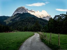
Aschauerloipe cross country trail

Along the Going Sonnseite where you can breathe in fresh winter air.
Bathing lake, Going (742 m)
Bathing lake, Going (742 m)
Langlaufen
Normaal
7,7 km
110 Hoogtemeters
De door u opgevraagde pagina is niet beschikbaar. U bent welkom om een nieuwe zoekopdracht op deze pagina te starten.
Along the Going Sonnseite where you can breathe in fresh winter air.
Bathing lake, Going (742 m)
Bathing lake, Going (742 m)
Langlaufen
Normaal
7,7 km
110 Hoogtemeters

On the north side up to the Ellmauer Halt summit 2,344 m.
Via ferrata

Intermediate circular hike with breathtaking views on the surrounding mountains. Attention: Trail no 828 is closed due to danger of falling rocks. Detour via path no. 816 and 827 via the Obere Regalm to the Baumgartenköpfl.
Hiking starting point Tannbichl, Going (857 m)
Hiking starting point Tannbichl, Going (857 m)
Wandelen
Normaal
4:45 u
9,8 km
760 Hoogtemeters

The best seat in the house for a view of the Wilder Kaiser!
Hiking starting point Going center (former tourist information Going) (764 m)
Hiking starting point Going center (former tourist information Going) (764 m)
Wandelen
Gemakkelijk
2:15 u
5,8 km
290 Hoogtemeters

mountain station Salvistabahn / Kleine Salve
Middle station Salvistabahn Itter
Wandelen
Normaal
2:45 u
7,4 km
360 Hoogtemeters

Difficult piste tour via the downhill, route no. 40a to Hochsöll Hexenwasser mountain station & further on via the Keat downhill route no. 43 to the Keat alpine pastures.
Cable Car Söll, ski touring car park
Mountain station, Hexenwasser gondola or Keat Almen
Skitocht
Moeilijk
1:30 u
4,0 km
762 Hoogtemeters

Baumgartenköpfl (Bergsteigergrab) – Wilder-Kaiser-Steig – Jubiläumssteig – Gruttenhütte
Brennender Palven (1,572 m)
Gruttenhütte, Ellmau (1,620 m)
Wandelen
Moeilijk
2:30 u
3,3 km
410 Hoogtemeters

More than 190 sport climbing routes, difficulty levels 3 to 9a+
Sportklimmen

Pleasant high-altitude walk taking in the mountain and Astbergsee lake - the mirror of the Wilder Kaiser!
Blattlalm, Going (1,246 m)
Blattlalm, Going (1,246 m)
Wandelen
Gemakkelijk
0:40 u
1,7 km
80 Hoogtemeters

Stripsenjochhaus – Eggersteig – Steinerne Rinne – Ellmauer Tor – Jubiläumssteig – Gruttenhütte
Stripsenjochhaus, St. Johann in Tirol (1,577 m)
Gaudeamushütte, Going (1,263 m)
Wandelen
Moeilijk
5:00 u
6,3 km
590 Hoogtemeters

A tour of the main filming locations of the TV series “Der Bergdoktor” (The Mountain Doctor) in Ellmau and Going, with a refreshment stop at the inn used during filming
Hiking starting point Tourist Info, Ellmau (800 m)
Hiking starting point Tourist Info, Ellmau (800 m)
Wandelen
Gemakkelijk
4:15 u
11,4 km
180 Hoogtemeters

Stripsenjochhaus - Griesner Alm - Griesenau
Stripsenjochhaus (1,577 m)
Griesenau, Kirchdorf (719 m)
Wandelen
Normaal
3:00 u
7,9 km

Ideal circuit for beginners to start exercising
Tourist Information Office, Going (766 m)
Tourist Information Office, Going (766 m)
Hardlopen
Gemakkelijk
0:20 u
3,1 km
75 Hoogtemeters
34 magnificent routes with a fantastic panoramic view of the summits.
Sportklimmen

Off the beaten track up to the Köpfing farmhouse. “Der Bergdoktor” (The Mountain Doctor) is a famous German-Austrian TV series, which is produced in the Wilder Kaiser region.
Bergdoktor parking lot, Söll
Bergdoktor parking lot, Söll
Wandelen
Gemakkelijk
3:00 u
8,4 km
370 Hoogtemeters

An adventure hike from Ellmau village centre to the Wochenbrunner Alm mountain hut from where you can enjoy stunning views and the Ellmau Stone Circle.
Hiking starting point Tourist Info, Ellmau (800 m)
Hiking starting point Tourist Info, Ellmau (800 m)
Wandelen
Gemakkelijk
4:30 u
13,5 km
530 Hoogtemeters
Following the Stampfangerbach stream on the way to Filzalm lake
Hiking starting point Bergbahn, Söll (725 m)
Hiking starting point Bergbahn, Söll (725 m)
Wandelen
Normaal
3:15 u
9,0 km
620 Hoogtemeters

The best hiking routes from village centre Scheffau to Lake Hinterstein.
Community Hall, Scheffau (740 m)
Hintersteiner See, Scheffau (890 m)
Wandelen
Normaal
1:30 u
4,5 km
240 Hoogtemeters

Bike tour to the idyllically situated Obere Regalm with a magnificent view.
Tourist Info, Going (764 m)
Tourist Info, Going (764 m)
Fietsen
Normaal
7,3 km
580 Hoogtemeters

A wild and romantic walk through the Kaiserwald forest with its wildlife park and cosy, traditional Tirolean parlour.
Hiking starting point Tourist Info, Ellmau (800 m)
Hiking starting point Tourist Info, Ellmau (800 m)
Wandelen
Normaal
3:30 u
9,0 km
300 Hoogtemeters

A leisurely circular trail along the sunny side of Ellmau. This is a lovely walk along the picturesque Kaiserloipe with views of the majestic mountains. An easy hike for the whole family.
Hiking starting point Tourist Info, Ellmau (800 m)
Hiking starting point Tourist Info, Ellmau (800 m)
Wandelen
Gemakkelijk
2:00 u
5,8 km
50 Hoogtemeters

Kufstein – Brentenjoch – Kaindlhütte
Kaiserlift summit station, Kufstein (1,255 m)
Kaindlhütte, Scheffau (1,293 m)
Wandelen
Gemakkelijk
1:30 u
2,9 km
220 Hoogtemeters

Ellmau hiking info point - Gasthof Au - Ellmauer Hof - Haflingertränke - Auwald - Ellmau hiking info point
Hiking starting point Tourist Info, Ellmau (800 m)
Hiking starting point Tourist Info, Ellmau (800 m)
Hardlopen
Gemakkelijk
1:30 u
9,8 km
300 Hoogtemeters
Gruttenhütte - Kaiser-Hochalm - Steiner-Hochalm - Jägersteig - Walleralm - Hochegg - Kaindlhütte
Gruttenhütte, Ellmau (1,620 m)
Hintersteiner See, Scheffau (889 m)
Wandelen
Normaal
5:30 u
13,5 km
560 Hoogtemeters
Over snow-covered meadows along the Goinger Sonnseite
Bathing lake, Going (742 m)
Bathing lake, Going (742 m)
Wandelen
Gemakkelijk
1:30 u
3,9 km
60 Hoogtemeters

Gaudeamushütte - Ellmauer Tor - Hintere Goinger Halt - Jubiläumssteig - Gruttenhütte
Gaudeamushütte, Going (1,263 m)
Gruttenhütte, Ellmau (1,620 m)
Wandelen
Moeilijk
5:30 u
5,9 km
1010 Hoogtemeters

Ellmau Tourist Information Office - golf course - Wochenbrunner Alm
Tourist Information Office, Ellmau (800 m)
Wochenbrunner Alm, Ellmau (1,085 m)
Fietsen
Normaal
4,8 km
260 Hoogtemeters
Gasteig – Wilder-Kaiser-Steig – Ursulablick – Gscheuerkopf – Graspoint-Hochalm – Graspoint-Niederalm – Going, Hüttling
Gasteig (750 m)
Hiking starting point Hüttling, Going (820 m)
Wandelen
Normaal
5:15 u
10,8 km
840 Hoogtemeters

Enjoy winter silence and an imperial panorama in Söll.
parking area Ahornsee, Söll (693 m)
parking area Ahornsee, Söll (693 m)
Langlaufen
Normaal
5,3 km
80 Hoogtemeters

Wonderful winter hike on the sunny side of the valley and easy return to the starting point by bus.
Hiking starting point Tourist Information Office, Ellmau (800 m)
Hiking starting point Tourist Information Office, Scheffau (737 m)
Wandelen
Gemakkelijk
2:15 u
6,1 km
40 Hoogtemeters

Gentle cycle tour from Wörgl via Söll, Scheffau, Ellmau and Going to St. Johann or vice versa!
Wörgl (511 m)
St. Johann (660 m)
Fietsen
Normaal
38,2 km
450 Hoogtemeters

Sunny walk over snowfields with enchanting landscape. An easy and enjoyable circuit in Going for the whole family.
Hiking starting point Going center (former tourist information Going) (764 m)
Hiking starting point Going center (former tourist information Going) (764 m)
Wandelen
Gemakkelijk
3:00 u
7,9 km
80 Hoogtemeters

Pure adrenaline is the motto of the Pölven trail on the third day of the Tour de Tirol
Hiking starting point Tourist Info, Söll (689 m)
Hiking starting point Tourist Info, Söll (689 m)
Hardlopen
Normaal
24,2 km
1260 Hoogtemeters

Past inn, farm and chapel in the Kaiser countryside.
Hiking starting point Going Center (former Tourist informatin Going)
Hiking starting point Going Center (former Tourist informatin Going)
Langlaufen
Gemakkelijk
1,2 km
10 Hoogtemeters

Leisurely path of reflection to the St. Anna chapel at Lengau
Parkplatz Liftstation Itter (655 m)
Lengauer Kapelle
Wandelen
Gemakkelijk
1:15 u
3,2 km
270 Hoogtemeters

This pleasant circular walk takes you to Söll’s war memorial in a beautiful section of forest.
Hiking starting point Tourist Info, Söll (689 m)
Hiking starting point Tourist Info, Söll (689 m)
Wandelen
Gemakkelijk
0:30 u
2,1 km
10 Hoogtemeters

Peace and strength, slow down and take a deep breath.
Ahornsee car park, Söll (693 m)
Ahornsee car park, Söll (693 m)
Wandelen
Normaal
4:45 u
12,0 km
220 Hoogtemeters

The Wilder Kaiser always in view.
Ahornsee car park, Söll (693 m)
Hiking starting point Bocking, Söll (670 m)
Wandelen
Gemakkelijk
3:30 u
6,0 km
130 Hoogtemeters

Cross-country trail with track for classic and free-style (skating)
Langlaufen
Normaal
0,5 km
10 Hoogtemeters

Very demanding round tour to the two eastern peaks in the Wilder Kaiser.
Hiking starting point Tannbichl, Going (857 m)
Hiking starting point Tannbichl, Going (857 m)
Wandelen
Moeilijk
9:00 u
13,0 km
1570 Hoogtemeters