


 Deutsch
 English
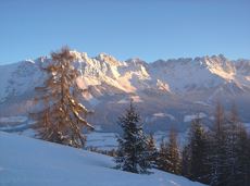
Klamml via ferrata
Gesloten
Difficulty D + spectacular two-rope bridge
Via ferrata
De door u opgevraagde pagina is niet beschikbaar. U bent welkom om een nieuwe zoekopdracht op deze pagina te starten.
Difficulty D + spectacular two-rope bridge
Via ferrata

From the Bergdoktorhaus to the Rübezahl-Alm mountain hut and the Carved Figures path to Ellmi’s Zauberwelt.
Hiking starting point Tourist Info, Ellmau (800 m)
Hiking starting point Tourist Info, Ellmau (800 m)
Wandelen
Gemakkelijk
5:30 u
15,8 km
730 Hoogtemeters

Stripsenjochhaus - Griesner Alm - Griesenau
Stripsenjochhaus (1,577 m)
Griesenau, Kirchdorf (719 m)
Wandelen
Normaal
3:00 u
7,9 km

Panoramic circular walk in the Wilder Kaiser leading to the highest mountain hut in the region.
Hiking starting point Tourist Info, Ellmau (800 m)
Hiking starting point Tourist Info, Ellmau (800 m)
Wandelen
Normaal
6:00 u
15,7 km
870 Hoogtemeters

Ideal tour for starters and high temperatures.
Hiking starting point Franzlhof, Söll (703 m)
Hiking starting point Franzlhof, Söll (703 m)
Wandelen
Gemakkelijk
0:45 u
2,4 km
50 Hoogtemeters

Stripsenjochhaus – Stripsenkopf – Feldberg – Scheibenbichlalmen – Griesenau – Gasteig
Stripsenjochhaus, St. Johann in Tirol (1,577 m)
Gasteig (750 m)
Wandelen
Normaal
6:30 u
16,1 km
640 Hoogtemeters

Picture-postcard panoramic scenery to Hintersteiner See lake, a natural gem.
Villag Center, Söll (689 m)
Hintersteiner See Lake, Scheffau (889 m)
Fietsen
Normaal
9,4 km
430 Hoogtemeters

Enjoy snowy forests and nature in winter.
Hiking starting point Tourist Info, Scheffau (738 m)
Hiking starting point Tourist Info, Scheffau (738 m)
Wandelen
Gemakkelijk
1:45 u
3,8 km
170 Hoogtemeters

A challenging circular mountainbike tour with plenty of welcoming refreshment stops.
Village Center, Söll (703 m)
Village Center, Söll (703 m)
Fietsen
Normaal
28,5 km
950 Hoogtemeters

Going, Hüttling – Graspoint-Niederalm – Obere Regalm – Brennender Palven – Gaudeamushütte – Klamml – Gruttenhütte
Hiking starting point Hüttling, Going (820 m)
Gaudeamushütte, Going (1,263 m) / Gruttenhütte, Ellmau (1,620 m)
Wandelen
Normaal
4:30 u
8,0 km
1120 Hoogtemeters

A moderately challenging panoramic circuit around the Astberg mountain.
Tourist Info, Going (764 m)
Tourist Info, Going (764 m)
Fietsen
Normaal
15,3 km
480 Hoogtemeters

Bike to the Hexenwasser theme park and Hochsöll.
Village Center, Söll (689 m)
Hexenwasser theme park, Hochsöll (1,150 m)
Fietsen
Normaal
5,1 km
480 Hoogtemeters

Short and easy circuit for beginners right next to the village of Söll.
Brunnhof field Söll
Brunnhof field Söll
Langlaufen
Gemakkelijk
0,9 km

Cross-country skiing in imperial style with two options: moderately challenging or just for pleasure.
Langlaufen
Gemakkelijk
5,5 km
50 Hoogtemeters
Hike via four mountain huts Rübezahl-Alm, Jägerhütte and Hochschwendt.
Hiking starting point Tourist Info, Ellmau (800 m)
Hiking starting point Tourist Info, Ellmau (800 m)
Wandelen
Gemakkelijk
6:15 u
14,0 km
600 Hoogtemeters

A beautiful tour around the Kalkstein mountain and Pillersee lake.
Tourist Info, Going (764 m)
Tourist Info, Going (764 m)
Fietsen
Normaal
66,9 km
550 Hoogtemeters

The heart of the tour is the deep, wonderful-to-climb chimney, which lends the tour an Alpine character.
Alpine klimroutes

Hike to the Gaudeamushütte mountain hut by the Wilder Kaiser
Wochenbrunner Alm, Ellmau (1,085 m)
Gaudeamushütte, Going (1,263 m)
Wandelen
Gemakkelijk
0:35 u
1,3 km
200 Hoogtemeters

Very demanding round tour to the two eastern peaks in the Wilder Kaiser.
Hiking starting point Tannbichl, Going (857 m)
Hiking starting point Tannbichl, Going (857 m)
Wandelen
Moeilijk
9:00 u
13,0 km
1570 Hoogtemeters

Cozy winter tour in Hochsöll with lift support, refreshments and view to the Hohe Salve.
Mountain station gondola Hexenwasser, Söll (1,150 m)
Mountain station gondola Hexenwasser, Söll (1,150 m)
Wandelen
Gemakkelijk
1:30 u
3,2 km
100 Hoogtemeters

Hikers, young and old alike, will find in this wild romantic gorge natural playgrounds such as bridges and balancing beams by streams and ponds.
Hiking starting point Tourist Info, Scheffau (738 m)
Hiking starting point Tourist Info, Scheffau (738 m)
Wandelen
Gemakkelijk
1:15 u
3,5 km
130 Hoogtemeters

The panoramic spot of the locals, steep and fascinating.
Hiking starting point Franzlhof, Söll (703 m)
Hiking starting point Franzlhof, Söll (703 m)
Wandelen
Normaal
5:00 u
8,5 km
880 Hoogtemeters

Is it about the journey or the destination? Well, one of the destinations of this stage is definitely the Hintersteiner See lake and its views. Surrounded by stunning mountain vistas, dwarf pine scrubland and beech forests, the lake is one of the cleanest and most beautiful mountain lakes in Tirol. The private pristine gem covers 56 hectares and measures 36 metres at its deepest point. With this picture-perfect backdrop, hikers will complete the remaining distance to the Kaindlhütte hut in no time.
Gaudeamushütte
Hintersteiner See
Wandelen
Normaal
6:30 u
15,1 km
888 Hoogtemeters

The Wilder Kaiser always in view.
Ahornsee car park, Söll (693 m)
Hiking starting point Bocking, Söll (670 m)
Wandelen
Gemakkelijk
3:30 u
6,0 km
130 Hoogtemeters

Ellmau village park - Hartkaiserbahn valley station - Bergschenke - Rübezahlalm - Jägerhütte - Hartkaiser summit station
Hiking starting point Tourist Info, Ellmau (800 m)
Hartkaiser summit station, Ellmau (1,555 m)
Hardlopen
Normaal
8,2 km
720 Hoogtemeters

Peace and strength, slow down and take a deep breath.
Ahornsee car park, Söll (693 m)
Ahornsee car park, Söll (693 m)
Wandelen
Normaal
4:45 u
12,0 km
220 Hoogtemeters

Explore the popular path past the TV backdrop on snowshoes.
Cable car valley station, Söll (725 m)
Cable car valley station, Söll (725 m)
Wandelen
Gemakkelijk
4:45 u
7,0 km
350 Hoogtemeters

Gentle cycle tour from Wörgl via Söll, Scheffau, Ellmau and Going to St. Johann or vice versa!
Wörgl (511 m)
St. Johann (660 m)
Fietsen
Normaal
38,2 km
450 Hoogtemeters

Challenging adventure hike to the Ellmauer Tor
Hiking starting point Wochenbrunner Alm, Ellmau (1,085 m)
Ellmauer Tor, Ellmau (2,001 m)
Wandelen
Normaal
5:00 u
7,7 km
900 Hoogtemeters

Savour the wonder of the winter landscape – experience the winter magic for yourself by crunching through the pristine snow with your snowshoes. Enjoy unique impressions and experiences as you explore the white winter splendour and take in the spectacular view over the surrounding mountain scenery.
Church square, Going (769 m)
Church square, Going (769 m)
Wandelen
Gemakkelijk
1:30 u
2,9 km
110 Hoogtemeters

Hike from the centre of Ellmau, along trail no. 14, through the "Spatlahner gorge" up to the Wochenbrunner Alm.
Hiking starting point Tourist Information Office, Ellmau (800 m)
Hiking starting point Tourist Information Office, Ellmau (800 m)
Wandelen
Gemakkelijk
1:30 u
4,4 km
285 Hoogtemeters

Alpine klimroutes

Beautiful circular walk around the frozen Lake Hinterstein.
Hiking starting point Seestüberl, Scheffau (890 m)
Hiking starting point Seestüberl, Scheffau (890 m)
Wandelen
Gemakkelijk
2:00 u
5,7 km
70 Hoogtemeters

The Pramarunde circuit - a scenically beautiful circuit at all times of the year
Tourist Information Office, Going (766 m)
Tourist Information Office, Going (766 m)
Hardlopen
Gemakkelijk
0:30 u
4,4 km
70 Hoogtemeters

A circular route full of experiences that leads from the Seebachgraben gorge to the Wilder-Kaiser-Steig trail - discover one of the most beautiful parts of Scheffau!
Hiking starting point Tourist Info, Scheffau (738 m)
Hiking starting point Tourist Info, Scheffau (738 m)
Wandelen
Normaal
7:00 u
19,6 km
1140 Hoogtemeters

An extensive exploration of “Moor & more”. The puzzle tour in the Wilder Kaiser forest is sure to be lots of fun, even for older children.
Hiking starting point Hüttling, Going (820 m)
Hiking starting point Hüttling, Going (820 m)
Wandelen
Gemakkelijk
3:00 u
8,0 km
380 Hoogtemeters

Wochenbrunner Alm – Gruttenhühtte
Hiking starting point Wochenbrunner Alm, Ellmau (1,085 m)
Gaudeamushütte, Going (1,263 m)
Wandelen
Normaal
1:45 u
2,6 km
530 Hoogtemeters

Energy trail with seven stations offering refreshing and relaxing experiences.
Hiking starting point Tourist Info, Scheffau (738 m)
Hiking starting point Tourist Info, Scheffau (738 m)
Wandelen
Gemakkelijk
0:45 u
2,3 km
70 Hoogtemeters

A short MTB tour to the Walleralm mountain inn, easily combined with other routes.
Parkplatz Pension Maier, Scheffau (925 m)
Parkplatz Walleralm, Söll (685 m)
Fietsen
Normaal
3,3 km
260 Hoogtemeters

Hartkaiserbahn summit station - Ellmis Zauberwald - Tanzbodensee lake - Hartkaiserbahn summit station
Hartkaiser summit station, Ellmau (1,555 m)
Hartkaiser summit station, Ellmau (1,555 m)
Hardlopen
Gemakkelijk
3,4 km
120 Hoogtemeters