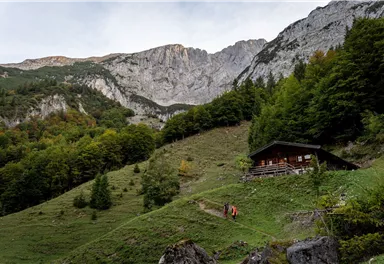
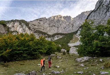
Oops, tour not found!

We are sorry, your requested page is not available. You can start a new search on this page!

Oops, tour not found!

We are sorry, your requested page is not available. You can start a new search on this page!

0 Routes and tours

Hartkaiser circuit Ellmau

Hartkaiser circuit Ellmau
Hartkaiser circuit EllmauPartially open
Hartkaiser circuit Ellmau

Hartkaiserbahn summit station - Ellmis Zauberwald - Tanzbodensee lake - Hartkaiserbahn summit station

Hartkaiser summit station, Ellmau (1,555 m)

Hartkaiser summit station, Ellmau (1,555 m)

Jogging

Easy

3,4 km

120 Elevation gain

Schiessling circuit

Schiessling circuit
Schiessling circuit
Schiessling circuit

Short tour with varied paths and views

Hiking starting point Tourismus Info, Scheffau (737 m)

Hiking starting point Tourismus Info, Scheffau (737 m)

Hiking

Easy

2:00 h

5,8 km

230 Elevation gain

Cross country connection Oberstegen/Söll–Scheffau

Cross country connection Oberstegen/Söll–Scheffau

2 villages - you fancy quiete and a very rural athmosphere - Scheffau is the place to go, or, you opt for a great variety of gastronomy and restaurants - then Söll is good to go. No matter how, your decision is always superb. The ski hiking route is purely flat, which also means it's great for everybody.

restaurant Oberstegen, Söll

village, Scheffau

Cross-country skiing

Easy

1,4 km

15 Elevation gain

Gentle snowshoe hike in the valley in Going

Gentle snowshoe hike in the valley in Going

Savour the wonder of the winter landscape – experience the winter magic for yourself by crunching through the pristine snow with your snowshoes. Enjoy unique impressions and experiences as you explore the white winter splendour and take in the spectacular view over the surrounding mountain scenery.

Church square, Going (769 m)

Church square, Going (769 m)

Hiking

1:30 h

2,9 km

110 Elevation gain

Village tour Scheffau

Village tour Scheffau

Round tour through Scheffau with panoramic views, refreshment by the stream and slowing down in the forest.

Hiking starting point Tourist Info, Scheffau (738 m)

Hiking starting point Tourist Info, Scheffau (738 m)

Hiking

Easy

1:15 h

4,3 km

90 Elevation gain

Schwendt circuit

Schwendt circuit
Schwendt circuit
Schwendt circuit

Leisurely hike through forest and across meadows to the sunny plateau of Going and back

Hiking starting point Going center (former tourist information Going) (764 m)

Hiking starting point Going center (former tourist information Going) (764 m)

Hiking

Easy

1:15 h

4,1 km

70 Elevation gain

Koller circular route

Koller circular route

Ancient path of the romans - a better stroll.

Hiking starting point Tourist Info, Söll (689 m)

Hiking starting point Tourist Info, Söll (689 m)

Hiking

Easy

1:00 h

3,0 km

55 Elevation gain

Ellmau village tour

Ellmau village tour
Ellmau village tour
Ellmau village tour

Postkarten circuit Ellmau Ellmau hiking info point – Kapellenpark – Marienkapelle – Ellmau Parish Church

Hiking starting point Tourist Info, Ellmau (800 m)

Hiking starting point Tourist Info, Ellmau (800 m)

Hiking

Easy

0:25 h

1,3 km

40 Elevation gain

Kaiserkrone Trail - SHORT TRAIL - official competition route

Kaiserkrone Trail - SHORT TRAIL - official competition route

The Kaiserkrone Trail is a trail running event with several competitions that lead around the Wilder Kaiser mountain massif. More about the event at: www.kaiserkrone.run

Start & Finish - village center of Scheffau (732 m), address: Dorf 45, 6351 Scheffau

Start & Finish - village center of Scheffau (732 m), address: Dorf 45, 6351 Scheffau

Jogging

Intermediate

8,3 km

490 Elevation gain

Hochlechen circular route

Hochlechen circular route

Old path - now renovated and featuring a pleasant series of ascents and descents.

Hiking starting point Bergbahn, Söll (725 m)

Hiking starting point Bergbahn, Söll (725 m)

Hiking

Intermediate

4:30 h

13,5 km

470 Elevation gain

Kaiserkrone - stage 5

Kaiserkrone - stage 5

Gasteig – Wilder-Kaiser-Steig – Ursulablick – Gscheuerkopf – Graspoint-Hochalm – Graspoint-Niederalm – Going, Hüttling

Gasteig (750 m)

Hiking starting point Hüttling, Going (820 m)

Hiking

Intermediate

5:15 h

10,8 km

840 Elevation gain

Eagle Walk Tirol

Eagle Walk Tirol
Eagle Walk Tirol
Eagle Walk Tirol

Hikers exploring Tirol on foot will feel as free as a bird. The eagle walk is one of the 'Great Walks' of Tyrol chosen by a jury. They offer hikers the chance to get away from it all, discover the beauty of nature and experience a true adventure in the Alps.

St. Johann in Tirol

Arlbergpass

Hiking

Difficult

426,0 km

30000 Elevation gain

Prama circular hiking route

Prama circular hiking route

Easy, flat circular path through the sunny village part 'Prama' for walkers  families with pushchairs.

Hiking starting point Going center (former tourist information Going) (764 m)

Hiking starting point Going center (former tourist information Going) (764 m)

Hiking

Easy

1:00 h

3,9 km

30 Elevation gain

Kaiserkrone - alternative route crossing through the Ellmauer Tor (Eggersteig trail - Jubiläumssteig trail)

Kaiserkrone - alternative route crossing through the Ellmauer Tor (Eggersteig trail - Jubiläumssteig trail)

Stripsenjochhaus – Eggersteig – Steinerne Rinne – Ellmauer Tor – Jubiläumssteig – Gruttenhütte

Stripsenjochhaus, St. Johann in Tirol (1,577 m)

Gaudeamushütte, Going (1,263 m)

Hiking

Difficult

5:00 h

6,3 km

590 Elevation gain

Eagle Walk Stage 03: Kaindlhütte - Kufstein

Eagle Walk Stage 03: Kaindlhütte - Kufstein

This stage takes hikers to the small town of Kufstein located on the banks of the Inn river – a town which has been celebrated in song and is steeped in history and character. Walkers make their way through the lush and verdant beauty of a pasture paradise with cosy huts and mountain restaurants before stopping for a rest at the Brentenjochhütte hut (delicious “Kiachl” are served every Saturday). With so many sights to marvel at, don't forget to keep an eye out for the nearly one thousand species of flowering plants native to the Kaiser Mountains. 

Hintersteiner See

Kufstein

Hiking

Intermediate

4:00 h

12,5 km

160 Elevation gain

Hike to Wochenbrunner Alm

Hike to Wochenbrunner Alm

Hike from the centre of Ellmau, along trail no. 14, through the "Spatlahner gorge" up to the Wochenbrunner Alm.

Hiking starting point Tourist Info, Ellmau (800 m)

Hiking starting point Tourist Info, Ellmau (800 m)

Hiking

Easy

1:30 h

4,4 km

285 Elevation gain

We are sorry, your requested page is not available. You can start a new search on this page!

282 Routes and tours

Hartkaiser circuit Ellmau

Hartkaiser circuit Ellmau
Hartkaiser circuit EllmauPartially open
Hartkaiser circuit Ellmau

Hartkaiserbahn summit station - Ellmis Zauberwald - Tanzbodensee lake - Hartkaiserbahn summit station

Hartkaiser summit station, Ellmau (1,555 m)

Hartkaiser summit station, Ellmau (1,555 m)

Jogging

Easy

3,4 km

120 Elevation gain

Schiessling circuit

Schiessling circuit
Schiessling circuit
Schiessling circuit

Short tour with varied paths and views

Hiking starting point Tourismus Info, Scheffau (737 m)

Hiking starting point Tourismus Info, Scheffau (737 m)

Hiking

Easy

2:00 h

5,8 km

230 Elevation gain

Cross country connection Oberstegen/Söll–Scheffau

Cross country connection Oberstegen/Söll–Scheffau

2 villages - you fancy quiete and a very rural athmosphere - Scheffau is the place to go, or, you opt for a great variety of gastronomy and restaurants - then Söll is good to go. No matter how, your decision is always superb. The ski hiking route is purely flat, which also means it's great for everybody.

restaurant Oberstegen, Söll

village, Scheffau

Cross-country skiing

Easy

1,4 km

15 Elevation gain

Gentle snowshoe hike in the valley in Going

Gentle snowshoe hike in the valley in Going

Savour the wonder of the winter landscape – experience the winter magic for yourself by crunching through the pristine snow with your snowshoes. Enjoy unique impressions and experiences as you explore the white winter splendour and take in the spectacular view over the surrounding mountain scenery.

Church square, Going (769 m)

Church square, Going (769 m)

Hiking

1:30 h

2,9 km

110 Elevation gain

Village tour Scheffau

Village tour Scheffau

Round tour through Scheffau with panoramic views, refreshment by the stream and slowing down in the forest.

Hiking starting point Tourist Info, Scheffau (738 m)

Hiking starting point Tourist Info, Scheffau (738 m)

Hiking

Easy

1:15 h

4,3 km

90 Elevation gain

Schwendt circuit

Schwendt circuit
Schwendt circuit
Schwendt circuit

Leisurely hike through forest and across meadows to the sunny plateau of Going and back

Hiking starting point Going center (former tourist information Going) (764 m)

Hiking starting point Going center (former tourist information Going) (764 m)

Hiking

Easy

1:15 h

4,1 km

70 Elevation gain

Koller circular route

Koller circular route

Ancient path of the romans - a better stroll.

Hiking starting point Tourist Info, Söll (689 m)

Hiking starting point Tourist Info, Söll (689 m)

Hiking

Easy

1:00 h

3,0 km

55 Elevation gain

Ellmau village tour

Ellmau village tour
Ellmau village tour
Ellmau village tour

Postkarten circuit Ellmau Ellmau hiking info point – Kapellenpark – Marienkapelle – Ellmau Parish Church

Hiking starting point Tourist Info, Ellmau (800 m)

Hiking starting point Tourist Info, Ellmau (800 m)

Hiking

Easy

0:25 h

1,3 km

40 Elevation gain

Kaiserkrone Trail - SHORT TRAIL - official competition route

Kaiserkrone Trail - SHORT TRAIL - official competition route

The Kaiserkrone Trail is a trail running event with several competitions that lead around the Wilder Kaiser mountain massif. More about the event at: www.kaiserkrone.run

Start & Finish - village center of Scheffau (732 m), address: Dorf 45, 6351 Scheffau

Start & Finish - village center of Scheffau (732 m), address: Dorf 45, 6351 Scheffau

Jogging

Intermediate

8,3 km

490 Elevation gain

Hochlechen circular route

Hochlechen circular route

Old path - now renovated and featuring a pleasant series of ascents and descents.

Hiking starting point Bergbahn, Söll (725 m)

Hiking starting point Bergbahn, Söll (725 m)

Hiking

Intermediate

4:30 h

13,5 km

470 Elevation gain

Kaiserkrone - stage 5

Kaiserkrone - stage 5

Gasteig – Wilder-Kaiser-Steig – Ursulablick – Gscheuerkopf – Graspoint-Hochalm – Graspoint-Niederalm – Going, Hüttling

Gasteig (750 m)

Hiking starting point Hüttling, Going (820 m)

Hiking

Intermediate

5:15 h

10,8 km

840 Elevation gain

Eagle Walk Tirol

Eagle Walk Tirol
Eagle Walk Tirol
Eagle Walk Tirol

Hikers exploring Tirol on foot will feel as free as a bird. The eagle walk is one of the 'Great Walks' of Tyrol chosen by a jury. They offer hikers the chance to get away from it all, discover the beauty of nature and experience a true adventure in the Alps.

St. Johann in Tirol

Arlbergpass

Hiking

Difficult

426,0 km

30000 Elevation gain

Prama circular hiking route

Prama circular hiking route

Easy, flat circular path through the sunny village part 'Prama' for walkers  families with pushchairs.

Hiking starting point Going center (former tourist information Going) (764 m)

Hiking starting point Going center (former tourist information Going) (764 m)

Hiking

Easy

1:00 h

3,9 km

30 Elevation gain

Kaiserkrone - alternative route crossing through the Ellmauer Tor (Eggersteig trail - Jubiläumssteig trail)

Kaiserkrone - alternative route crossing through the Ellmauer Tor (Eggersteig trail - Jubiläumssteig trail)

Stripsenjochhaus – Eggersteig – Steinerne Rinne – Ellmauer Tor – Jubiläumssteig – Gruttenhütte

Stripsenjochhaus, St. Johann in Tirol (1,577 m)

Gaudeamushütte, Going (1,263 m)

Hiking

Difficult

5:00 h

6,3 km

590 Elevation gain

Eagle Walk Stage 03: Kaindlhütte - Kufstein

Eagle Walk Stage 03: Kaindlhütte - Kufstein

This stage takes hikers to the small town of Kufstein located on the banks of the Inn river – a town which has been celebrated in song and is steeped in history and character. Walkers make their way through the lush and verdant beauty of a pasture paradise with cosy huts and mountain restaurants before stopping for a rest at the Brentenjochhütte hut (delicious “Kiachl” are served every Saturday). With so many sights to marvel at, don't forget to keep an eye out for the nearly one thousand species of flowering plants native to the Kaiser Mountains. 

Hintersteiner See

Kufstein

Hiking

Intermediate

4:00 h

12,5 km

160 Elevation gain

Hike to Wochenbrunner Alm

Hike to Wochenbrunner Alm

Hike from the centre of Ellmau, along trail no. 14, through the "Spatlahner gorge" up to the Wochenbrunner Alm.

Hiking starting point Tourist Info, Ellmau (800 m)

Hiking starting point Tourist Info, Ellmau (800 m)

Hiking

Easy

1:30 h

4,4 km

285 Elevation gain

Oops, tour not found!

282 Routes and tours

Hartkaiser circuit Ellmau

Hartkaiser circuit Ellmau
Hartkaiser circuit EllmauPartially open
Hartkaiser circuit Ellmau

Hartkaiserbahn summit station - Ellmis Zauberwald - Tanzbodensee lake - Hartkaiserbahn summit station

Hartkaiser summit station, Ellmau (1,555 m)

Hartkaiser summit station, Ellmau (1,555 m)

Jogging

Easy

3,4 km

120 Elevation gain

Schiessling circuit

Schiessling circuit
Schiessling circuit
Schiessling circuit

Short tour with varied paths and views

Hiking starting point Tourismus Info, Scheffau (737 m)

Hiking starting point Tourismus Info, Scheffau (737 m)

Hiking

Easy

2:00 h

5,8 km

230 Elevation gain

Cross country connection Oberstegen/Söll–Scheffau

Cross country connection Oberstegen/Söll–Scheffau

2 villages - you fancy quiete and a very rural athmosphere - Scheffau is the place to go, or, you opt for a great variety of gastronomy and restaurants - then Söll is good to go. No matter how, your decision is always superb. The ski hiking route is purely flat, which also means it's great for everybody.

restaurant Oberstegen, Söll

village, Scheffau

Cross-country skiing

Easy

1,4 km

15 Elevation gain

Gentle snowshoe hike in the valley in Going

Gentle snowshoe hike in the valley in Going

Savour the wonder of the winter landscape – experience the winter magic for yourself by crunching through the pristine snow with your snowshoes. Enjoy unique impressions and experiences as you explore the white winter splendour and take in the spectacular view over the surrounding mountain scenery.

Church square, Going (769 m)

Church square, Going (769 m)

Hiking

1:30 h

2,9 km

110 Elevation gain

Village tour Scheffau

Village tour Scheffau

Round tour through Scheffau with panoramic views, refreshment by the stream and slowing down in the forest.

Hiking starting point Tourist Info, Scheffau (738 m)

Hiking starting point Tourist Info, Scheffau (738 m)

Hiking

Easy

1:15 h

4,3 km

90 Elevation gain

Schwendt circuit

Schwendt circuit
Schwendt circuit
Schwendt circuit

Leisurely hike through forest and across meadows to the sunny plateau of Going and back

Hiking starting point Going center (former tourist information Going) (764 m)

Hiking starting point Going center (former tourist information Going) (764 m)

Hiking

Easy

1:15 h

4,1 km

70 Elevation gain

Koller circular route

Koller circular route

Ancient path of the romans - a better stroll.

Hiking starting point Tourist Info, Söll (689 m)

Hiking starting point Tourist Info, Söll (689 m)

Hiking

Easy

1:00 h

3,0 km

55 Elevation gain

Ellmau village tour

Ellmau village tour
Ellmau village tour
Ellmau village tour

Postkarten circuit Ellmau Ellmau hiking info point – Kapellenpark – Marienkapelle – Ellmau Parish Church

Hiking starting point Tourist Info, Ellmau (800 m)

Hiking starting point Tourist Info, Ellmau (800 m)

Hiking

Easy

0:25 h

1,3 km

40 Elevation gain

Kaiserkrone Trail - SHORT TRAIL - official competition route

Kaiserkrone Trail - SHORT TRAIL - official competition route

The Kaiserkrone Trail is a trail running event with several competitions that lead around the Wilder Kaiser mountain massif. More about the event at: www.kaiserkrone.run

Start & Finish - village center of Scheffau (732 m), address: Dorf 45, 6351 Scheffau

Start & Finish - village center of Scheffau (732 m), address: Dorf 45, 6351 Scheffau

Jogging

Intermediate

8,3 km

490 Elevation gain

Hochlechen circular route

Hochlechen circular route

Old path - now renovated and featuring a pleasant series of ascents and descents.

Hiking starting point Bergbahn, Söll (725 m)

Hiking starting point Bergbahn, Söll (725 m)

Hiking

Intermediate

4:30 h

13,5 km

470 Elevation gain

Kaiserkrone - stage 5

Kaiserkrone - stage 5

Gasteig – Wilder-Kaiser-Steig – Ursulablick – Gscheuerkopf – Graspoint-Hochalm – Graspoint-Niederalm – Going, Hüttling

Gasteig (750 m)

Hiking starting point Hüttling, Going (820 m)

Hiking

Intermediate

5:15 h

10,8 km

840 Elevation gain

Eagle Walk Tirol

Eagle Walk Tirol
Eagle Walk Tirol
Eagle Walk Tirol

Hikers exploring Tirol on foot will feel as free as a bird. The eagle walk is one of the 'Great Walks' of Tyrol chosen by a jury. They offer hikers the chance to get away from it all, discover the beauty of nature and experience a true adventure in the Alps.

St. Johann in Tirol

Arlbergpass

Hiking

Difficult

426,0 km

30000 Elevation gain

Prama circular hiking route

Prama circular hiking route

Easy, flat circular path through the sunny village part 'Prama' for walkers  families with pushchairs.

Hiking starting point Going center (former tourist information Going) (764 m)

Hiking starting point Going center (former tourist information Going) (764 m)

Hiking

Easy

1:00 h

3,9 km

30 Elevation gain

Kaiserkrone - alternative route crossing through the Ellmauer Tor (Eggersteig trail - Jubiläumssteig trail)

Kaiserkrone - alternative route crossing through the Ellmauer Tor (Eggersteig trail - Jubiläumssteig trail)

Stripsenjochhaus – Eggersteig – Steinerne Rinne – Ellmauer Tor – Jubiläumssteig – Gruttenhütte

Stripsenjochhaus, St. Johann in Tirol (1,577 m)

Gaudeamushütte, Going (1,263 m)

Hiking

Difficult

5:00 h

6,3 km

590 Elevation gain

Eagle Walk Stage 03: Kaindlhütte - Kufstein

Eagle Walk Stage 03: Kaindlhütte - Kufstein

This stage takes hikers to the small town of Kufstein located on the banks of the Inn river – a town which has been celebrated in song and is steeped in history and character. Walkers make their way through the lush and verdant beauty of a pasture paradise with cosy huts and mountain restaurants before stopping for a rest at the Brentenjochhütte hut (delicious “Kiachl” are served every Saturday). With so many sights to marvel at, don't forget to keep an eye out for the nearly one thousand species of flowering plants native to the Kaiser Mountains. 

Hintersteiner See

Kufstein

Hiking

Intermediate

4:00 h

12,5 km

160 Elevation gain

Hike to Wochenbrunner Alm

Hike to Wochenbrunner Alm

Hike from the centre of Ellmau, along trail no. 14, through the "Spatlahner gorge" up to the Wochenbrunner Alm.

Hiking starting point Tourist Info, Ellmau (800 m)

Hiking starting point Tourist Info, Ellmau (800 m)

Hiking

Easy

1:30 h

4,4 km

285 Elevation gain

Protected by