


 Deutsch
 English
Prama circuit

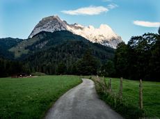
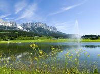
The Pramarunde circuit - a scenically beautiful circuit at all times of the year
Tourist Information Office, Going (766 m)
Tourist Information Office, Going (766 m)
Hardlopen
Gemakkelijk
0:30 u
4,4 km
70 Hoogtemeters
De door u opgevraagde pagina is niet beschikbaar. U bent welkom om een nieuwe zoekopdracht op deze pagina te starten.
The Pramarunde circuit - a scenically beautiful circuit at all times of the year
Tourist Information Office, Going (766 m)
Tourist Information Office, Going (766 m)
Hardlopen
Gemakkelijk
0:30 u
4,4 km
70 Hoogtemeters

Ellmau hiking info - Church - Gasthof Au - Forstmeile Ellmau
Hiking starting point Tourist Info, Ellmau (800 m)
Hiking starting point Tourist Info, Ellmau (800 m)
Hardlopen
Gemakkelijk
5,5 km
150 Hoogtemeters

The circuit around Going is a lengthy and demanding tour with a great variety of different sections.
Tourist Information Office, Going (766 m)
Tourist Information Office, Going (766 m)
Hardlopen
Normaal
1:25 u
11,2 km
280 Hoogtemeters

Alpine klimroutes

60-metre high rock dome – the Mecca for extreme climbers
Sportklimmen
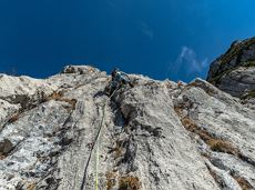
Alpine klimroutes

Nice circular hike through Going with visits to numerous chapels.
Hiking starting point Going center (former tourist information Going) (764 m)
Hiking starting point Going center (former tourist information Going) (764 m)
Wandelen
Gemakkelijk
2:45 u
9,3 km
210 Hoogtemeters

A short winter walk on Hartkaiser hrough Ellmi's magical world.
Hiking starting point Tourist Info, Ellmau (800 m)
Hiking starting point Tourist Info, Ellmau (800 m)
Wandelen
Gemakkelijk
0:30 u
1,0 km
25 Hoogtemeters

Explore the sunny foot of the Pölven mountain.
Langlaufen
Gemakkelijk
0,9 km

Alpine klimroutes

Langlaufen
Gemakkelijk
1,0 km

Going, Hüttling - Schleierwasserfall - Obere Regalm - Baumgartenköpfl (Bergsteigergrab) - Gaudeamushütte - Ellmauer Tor - Hintere Goinger Halt - Jubiläumssteig - Gruttenhütte - Kaiser-Hochalm - Steiner-Hochalm - Hinterschießling Alm - Rehbachklamm - Scheffau, Dorf
Hiking starting point Hüttling, Going (820 m)
Scheffau village (738 m)
Wandelen
Moeilijk
14:00 u
24,6 km
2060 Hoogtemeters

Stripsenjochhaus – Stripsenkopf – Feldberg – Scheibenbichlalmen – Griesenau – Gasteig
Stripsenjochhaus, St. Johann in Tirol (1,577 m)
Gasteig (750 m)
Wandelen
Normaal
6:30 u
16,1 km
640 Hoogtemeters

Enjoy unique panoramic views of the impressive mountains from the Biedringer Platte plateau.
Hiking starting point Tourist Info, Ellmau (800 m)
Hiking starting point Tourist Info, Ellmau (800 m)
Wandelen
Gemakkelijk
4:15 u
12,6 km
470 Hoogtemeters

Gruttenhütte - Kaiser-Hochalm - Steiner-Hochalm - Jägersteig - Walleralm - Hochegg - Kaindlhütte
Gruttenhütte, Ellmau (1,620 m)
Hintersteiner See, Scheffau (889 m)
Wandelen
Normaal
5:30 u
13,5 km
560 Hoogtemeters

Wild and free - 5 days of hiking on old paths around the Wilder Kaiser The five-day hike from hut to hut is one of the most beautiful multi-day circular tours in Tirol. It takes mountain walkers along a route of around 58 kilometres, featuring ascents and descents with a difference in altitude of approximately 4,000 metres as they circle around the imposing Wilder Kaiser massif.
Hiking starting point Hüttling, Going (820 m)
Hiking starting point Hüttling, Going (820 m)
Wandelen
Normaal
27 u
57,7 km
4000 Hoogtemeters

Wonderful winter hike on the sunny side of the valley and easy return to the starting point by bus.
Hiking starting point Tourist Information Office, Ellmau (800 m)
Hiking starting point Tourist Information Office, Scheffau (737 m)
Wandelen
Gemakkelijk
2:15 u
6,1 km
40 Hoogtemeters
Gasteig – Wilder-Kaiser-Steig – Ursulablick – Gscheuerkopf – Graspoint-Hochalm – Graspoint-Niederalm – Going, Hüttling
Gasteig (750 m)
Hiking starting point Hüttling, Going (820 m)
Wandelen
Normaal
5:15 u
10,8 km
840 Hoogtemeters

Leisurely path of reflection to the St. Anna chapel at Lengau
Parkplatz Liftstation Itter (655 m)
Lengauer Kapelle
Wandelen
Gemakkelijk
1:15 u
3,2 km
270 Hoogtemeters

Fork 823/826 – via waterfall – Veitskirche – Steiner-Hochalm
Fork on the Wilder-Kaiser-Steig 823/826 (1,405 m)
Steiner-Hochalm, Scheffau (1,257 m)
Wandelen
Normaal
2:30 u
3,8 km
360 Hoogtemeters

A circuit around the mountain that the locals love for its great view.
Hiking starting point Franzlhof, Söll (703 m)
Hiking starting point Franzlhof, Söll (703 m)
Wandelen
Normaal
6:00 u
17,8 km
670 Hoogtemeters

A classic amongst the via ferratas on the Wilder Kaiser massif – ideal as a 2-day tour.
Via ferrata

Beautiful, Alpine sport climbing with consistent difficulty.
Alpine klimroutes

On the north side up to the Ellmauer Halt summit 2,344 m.
Via ferrata
Short, promising cross-country ski circuit with combination options.
Langlaufen
Normaal
2,2 km
40 Hoogtemeters

Via ferrata
Mittelschwierige Aufstiegsroute entlang der Piste Nr. 80 auf den Hartkaiser.
Hartkaiserbahn Talstation,
Hartkaiserbahn Bergstation, Ellmau (1.520 m)
Skitocht
Normaal
2:00 u
3,5 km
700 Hoogtemeters

Bike tour to the idyllically situated Obere Regalm with a magnificent view.
Tourist Info, Going (764 m)
Tourist Info, Going (764 m)
Fietsen
Normaal
7,3 km
580 Hoogtemeters

Panoramic circular walk in the Wilder Kaiser leading to the highest mountain hut in the region.
Hiking starting point Tourist Info, Ellmau (800 m)
Hiking starting point Tourist Info, Ellmau (800 m)
Wandelen
Normaal
6:00 u
15,7 km
870 Hoogtemeters

Hike to the Gaudeamushütte mountain hut by the Wilder Kaiser
Wochenbrunner Alm, Ellmau (1,085 m)
Gaudeamushütte, Going (1,263 m)
Wandelen
Gemakkelijk
0:35 u
1,3 km
200 Hoogtemeters
A beautiful easy hike at the foot of the Wilder Kaiser
Hiking starting point Tourist Info, Ellmau (800 m)
Hiking starting point Tourist Info, Ellmau (800 m)
Wandelen
Gemakkelijk
1:45 u
5,9 km
60 Hoogtemeters

The best hiking routes from village centre Scheffau to Lake Hinterstein.
Community Hall, Scheffau (740 m)
Hintersteiner See, Scheffau (890 m)
Wandelen
Normaal
1:30 u
4,5 km
240 Hoogtemeters

A beautiful tour around the Kalkstein mountain and Pillersee lake.
Tourist Info, Going (764 m)
Tourist Info, Going (764 m)
Fietsen
Normaal
66,9 km
550 Hoogtemeters

Gruttenhütte - Kaiser-Hochalm - Steiner-Hochalm - Hinterschießling Alm - Rehbachklamm - Scheffau, Dorf
Gruttenhütte, Ellmau (1,620 m)
Scheffau village (889 m)
Wandelen
Normaal
4:30 u
11,4 km
190 Hoogtemeters

Dizzying experience via snack stations to the waterfall via unmanaged alpine pastures to the Hexenwasser. Return to the valley by cable car or on foot.
Hiking starting point Bergbahn, Söll (725 m)
Hiking starting point Bergbahn, Söll (725 m)
Wandelen
Normaal
2:00 u
5,6 km
500 Hoogtemeters

This tour is rich in variety and includes slabs, water grooves, as well as a strong overhang and a traverse with an undercling passage.
Alpine klimroutes

The panoramic spot of the locals, steep and fascinating.
Hiking starting point Franzlhof, Söll (703 m)
Hiking starting point Franzlhof, Söll (703 m)
Wandelen
Normaal
5:00 u
8,5 km
880 Hoogtemeters

The best seat in the house for a view of the Wilder Kaiser!
Tourist Information Office, Going (766 m)
Tourist Information Office, Going (766 m)
Fietsen
Normaal
2:00 u
7,5 km
350 Hoogtemeters

Culinary tour on the Hohe Salve
Bergstation Rabennest (1.150 m)
Bergstation Rabennest (1.150 m)
Wandelen
Gemakkelijk
1:30 u
4,0 km
160 Hoogtemeters

Via ferrata