


 Deutsch
 English
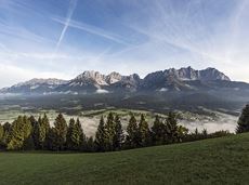
Winter hiking route Hexenwasser
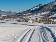
Cozy winter walk through the snowy witch water.
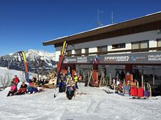
Mountain station gondola Hexenwasser, Söll (1,150 m)
Mountain station gondola Hexenwasser, Söll (1,150 m)
Wandelen
Gemakkelijk
0:30 u
1,2 km
45 Hoogtemeters
De door u opgevraagde pagina is niet beschikbaar. U bent welkom om een nieuwe zoekopdracht op deze pagina te starten.
Cozy winter walk through the snowy witch water.
Mountain station gondola Hexenwasser, Söll (1,150 m)
Mountain station gondola Hexenwasser, Söll (1,150 m)
Wandelen
Gemakkelijk
0:30 u
1,2 km
45 Hoogtemeters

Extended walk through the landscape of Scheffau and Söll
Hiking starting point Tourist Info, Scheffau (738 m)
Hiking starting point Tourist Info, Scheffau (738 m)
Wandelen
Gemakkelijk
3:30 u
8,8 km
210 Hoogtemeters
Embark on a sunny cross-country safari in the snowfields around the Sölllandl.
Spar super market Söll
Spar super market Söll
Langlaufen
Normaal
5,9 km
70 Hoogtemeters

Going, Hüttling – Graspoint-Niederalm – Obere Regalm – Brennender Palven – Gaudeamushütte – Klamml – Gruttenhütte
Hiking starting point Hüttling, Going (820 m)
Gaudeamushütte, Going (1,263 m) / Gruttenhütte, Ellmau (1,620 m)
Wandelen
Normaal
4:30 u
8,0 km
1120 Hoogtemeters

Bike to the Hexenwasser theme park and Hochsöll.
Village Center, Söll (689 m)
Hexenwasser theme park, Hochsöll (1,150 m)
Fietsen
Normaal
5,1 km
480 Hoogtemeters

A tour of the main filming locations of the TV series “Der Bergdoktor” (The Mountain Doctor) in Ellmau and Going, with a refreshment stop at the inn used during filming
Hiking starting point Tourist Info, Ellmau (800 m)
Hiking starting point Tourist Info, Ellmau (800 m)
Wandelen
Gemakkelijk
4:15 u
11,4 km
180 Hoogtemeters

The Pramarunde circuit - a scenically beautiful circuit at all times of the year
Tourist Information Office, Going (766 m)
Tourist Information Office, Going (766 m)
Hardlopen
Gemakkelijk
0:30 u
4,4 km
70 Hoogtemeters

This familyfriendly hike leads you along the panoramic trail from the Brandstadl mountain in Scheffau to the Hartkaiser mountain in Ellmau.
Brandstadlbahn mountain station, Scheffau (1,650 m) or Hartkaiserbahn mountain station, Ellmau (1.550 m)
Brandstadlbahn mountain station, Scheffau (1,650 m) or Hartkaiserbahn mountain station, Ellmau (1.550 m)
Wandelen
Gemakkelijk
1:50 u
6,0 km
170 Hoogtemeters

Ideal circuit for beginners to start exercising
Tourist Information Office, Going (766 m)
Tourist Information Office, Going (766 m)
Hardlopen
Gemakkelijk
0:20 u
3,1 km
75 Hoogtemeters

Alpine klimroutes

Cross-country skiing on an isolated plateau, surrounded by forest and winter meadows.
Langlaufen
Gemakkelijk
1,3 km
30 Hoogtemeters

Short beginners’ trail - central, easy and crisp!
Langlaufen
Gemakkelijk
1,0 km
Hike via four mountain huts Rübezahl-Alm, Jägerhütte and Hochschwendt.
Hiking starting point Tourist Info, Ellmau (800 m)
Hiking starting point Tourist Info, Ellmau (800 m)
Wandelen
Gemakkelijk
6:15 u
14,0 km
600 Hoogtemeters

A classic amongst the via ferratas on the Wilder Kaiser massif – ideal as a 2-day tour.
Via ferrata

A nice run around the crystal-clear lake Hintersteiner See.
Starting point Seestüberl, Scheffau (822 m)
Starting point Seestüberl, Scheffau (882 m)
Hardlopen
Gemakkelijk
5,2 km
180 Hoogtemeters

Moderate tour to the Schleier Waterfall, a great outdoor experience.
Tourist Info, Going (764 m)
Tourist Info, Going (764 m)
Fietsen
Normaal
6,6 km
410 Hoogtemeters
This short and easy valley circuit takes you around the village of Going am Wilden Kaiser and past the bathing lake, a delightful spot to cool off in fine weather.
Hiking starting point Going center (former tourist information Going) (764 m)
Hiking starting point Going center (former tourist information Going) (764 m)
Wandelen
Gemakkelijk
1:00 u
6,4 km
110 Hoogtemeters

Approaching from the north, this trail leads through the Steinerne Rinne to the majestic Ellmauer Tor.
Griesner Alm, 988 m
Wochenbrunner Alm, Ellmau (1,085 m)
Wandelen
Moeilijk
5:45 u
8,1 km
1060 Hoogtemeters

The best seat in the house for a view of the Wilder Kaiser!
Tourist Information Office, Going (766 m)
Tourist Information Office, Going (766 m)
Fietsen
Normaal
2:00 u
7,5 km
350 Hoogtemeters

A tour of the main filming locations of the TV series “Der Bergdoktor” (The Mountain Doctor) in Ellmau, with a refreshment stop at the inn used during filming
Hiking starting point Tourist Info, Ellmau (798 m)
Hiking starting point Tourist Info, Ellmau (798 m)
Wandelen
Gemakkelijk
2:15 u
7,5 km
200 Hoogtemeters

Climb to the best viewpoint in the mountains, where the Wilder Kaiser is within touching distance.
Hiking starting point Going center (former tourist information Going) (764 m)
Hiking starting point Going center (former tourist information Going) (764 m)
Wandelen
Normaal
4:30 u
10,7 km
360 Hoogtemeters

Intermediate circular hike with breathtaking views on the surrounding mountains. Attention: Trail no 828 is closed due to danger of falling rocks. Detour via path no. 816 and 827 via the Obere Regalm to the Baumgartenköpfl.
Hiking starting point Tannbichl, Going (857 m)
Hiking starting point Tannbichl, Going (857 m)
Wandelen
Normaal
4:45 u
9,8 km
760 Hoogtemeters

Leisurely path of reflection to the St. Anna chapel at Lengau
Parkplatz Liftstation Itter (655 m)
Lengauer Kapelle
Wandelen
Gemakkelijk
1:15 u
3,2 km
270 Hoogtemeters

Fork 823/826 – via waterfall – Veitskirche – Steiner-Hochalm
Fork on the Wilder-Kaiser-Steig 823/826 (1,405 m)
Steiner-Hochalm, Scheffau (1,257 m)
Wandelen
Normaal
2:30 u
3,8 km
360 Hoogtemeters
Circular cycling route for leisure bikers between the four villages of the Kaiser region.
anywhere along the tour
anywhere along the tour
Fietsen
Normaal
38,5 km
550 Hoogtemeters

Alpine klimroutes
Gasteig – Wilder-Kaiser-Steig – Ursulablick – Gscheuerkopf – Graspoint-Hochalm – Graspoint-Niederalm – Going, Hüttling
Gasteig (750 m)
Hiking starting point Hüttling, Going (820 m)
Wandelen
Normaal
5:15 u
10,8 km
840 Hoogtemeters

Hikers, young and old alike, will find in this wild romantic gorge natural playgrounds such as bridges and balancing beams by streams and ponds.
Hiking starting point Tourist Info, Scheffau (738 m)
Hiking starting point Tourist Info, Scheffau (738 m)
Wandelen
Gemakkelijk
1:15 u
3,5 km
130 Hoogtemeters

Ancient path of the romans - a better stroll.
Hiking starting point Tourist Info, Söll (689 m)
Hiking starting point Tourist Info, Söll (689 m)
Wandelen
Gemakkelijk
1:00 u
3,0 km
55 Hoogtemeters

Pleasant hike through forests and across meadows to the sunny plateau of Going and back
Hiking starting point Going center (former tourist information Going) (764 m)
Hiking starting point Going center (former tourist information Going) (764 m)
Wandelen
Gemakkelijk
1:15 u
4,1 km
70 Hoogtemeters

Varied round tour with many refreshments and wonderful views
Tourist Information Office, Scheffau (737 m)
Tourist Information Office, Scheffau (737 m)
Fietsen
Normaal
23,6 km
660 Hoogtemeters

Difficult piste tour via the downhill, route no. 40a to Hochsöll Hexenwasser mountain station & further on via the Keat downhill route no. 43 to the Keat alpine pastures.
Cable Car Söll, ski touring car park
Mountain station, Hexenwasser gondola or Keat Almen
Skitocht
Moeilijk
1:30 u
4,0 km
762 Hoogtemeters

The Hintere Goinger Halt (2,193 m) is considered to be the easiest summit to reach in the Wilder Kaiser.
Hiking starting point Wochenbrunner Alm, Ellmau (1,085 m)
Hiking starting point Wochenbrunner Alm, Ellmau (1,085 m)
Wandelen
Moeilijk
6:30 u
8,9 km
1090 Hoogtemeters

A short MTB tour to the Walleralm mountain inn, easily combined with other routes.
Parkplatz Pension Maier, Scheffau (925 m)
Parkplatz Walleralm, Söll (685 m)
Fietsen
Normaal
3,3 km
260 Hoogtemeters

An extensive exploration of “Moor & more”. The puzzle tour in the Wilder Kaiser forest is sure to be lots of fun, even for older children.
Hiking starting point Hüttling, Going (820 m)
Hiking starting point Hüttling, Going (820 m)
Wandelen
Gemakkelijk
3:00 u
8,0 km
380 Hoogtemeters

Culinary tour on the Hohe Salve
Bergstation Rabennest (1.150 m)
Bergstation Rabennest (1.150 m)
Wandelen
Gemakkelijk
1:30 u
4,0 km
160 Hoogtemeters

Pleasant circular hiking trail through forests and meadows to the romantically situated moor lake.
Hiking starting point Franzlhof, Söll (703 m)
Hiking starting point Franzlhof, Söll (703 m)
Wandelen
Normaal
2:00 u
5,7 km
240 Hoogtemeters

Stripsenjochhaus – Eggersteig – Steinerne Rinne – Ellmauer Tor – Jubiläumssteig – Gruttenhütte
Stripsenjochhaus, St. Johann in Tirol (1,577 m)
Gaudeamushütte, Going (1,263 m)
Wandelen
Moeilijk
5:00 u
6,3 km
590 Hoogtemeters

More than 190 sport climbing routes, difficulty levels 3 to 9a+
Sportklimmen

A challenging circular mountainbike tour with plenty of welcoming refreshment stops.
Village Center, Söll (703 m)
Village Center, Söll (703 m)
Fietsen
Normaal
28,5 km
950 Hoogtemeters