Hoppala, route niet gevonden

De door u opgevraagde pagina is niet beschikbaar. U bent welkom om een nieuwe zoekopdracht op deze pagina te starten.

0 Routes & tochten

Ellmau village tour

Ellmau village tour
Ellmau village tour
Ellmau village tour

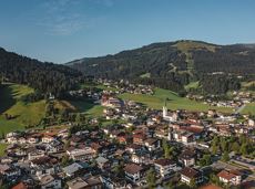
Postkarten circuit Ellmau Ellmau hiking info point – Kapellenpark – Marienkapelle – Ellmau Parish Church

Hiking starting point Tourist Info, Ellmau (800 m)

Hiking starting point Tourist Info, Ellmau (800 m)

Wandelen

Gemakkelijk

0:25 u

1,3 km

40 Hoogtemeters

Prama circuit

Prama circuit
Prama circuit
Prama circuit

The Pramarunde circuit - a scenically beautiful circuit at all times of the year

Tourist Information Office, Going (766 m)

Tourist Information Office, Going (766 m)

Hardlopen

Gemakkelijk

0:30 u

4,4 km

70 Hoogtemeters

Söller village tour

Söller village tour
Söller village tour
Söller village tour

Looping the village of Söll, the sight seeing hike!

Hiking starting point Tourist Info, Söll (689 m)

Hiking starting point Tourist Info, Söll (689 m)

Wandelen

Gemakkelijk

1:00 u

3,7 km

50 Hoogtemeters

MTB-Tour around Juffinger Jöchl

MTB-Tour around Juffinger Jöchl

A crisp, varied tour from Söll via the Lengau to Bad Häring and over the Werlberg, past the Juffinger Jöchl back to Söll. Between the individual forest sections, you are rewarded again and again with magnificent views of large parts of the Inntal valley.

Village centre, Söll (689 m)

Village centre, Söll (689 m)

Fietsen

Moeilijk

24,0 km

900 Hoogtemeters

Winter walk on Hartkaiser

Winter walk on Hartkaiser

A short winter walk on Hartkaiser hrough Ellmi's magical world.

Hiking starting point Tourist Info, Ellmau (800 m)

Hiking starting point Tourist Info, Ellmau (800 m)

Wandelen

Gemakkelijk

0:30 u

1,0 km

25 Hoogtemeters

Kaiserkrone - alternative route crossing through the Ellmauer Tor (Eggersteig trail - Jubiläumssteig trail)

Kaiserkrone - alternative route crossing through the Ellmauer Tor (Eggersteig trail - Jubiläumssteig trail)

Stripsenjochhaus – Eggersteig – Steinerne Rinne – Ellmauer Tor – Jubiläumssteig – Gruttenhütte

Stripsenjochhaus, St. Johann in Tirol (1,577 m)

Gaudeamushütte, Going (1,263 m)

Wandelen

Moeilijk

5:00 u

6,3 km

590 Hoogtemeters

Wochenbrunnweg

Wochenbrunnweg
Wochenbrunnweg
Wochenbrunnweg

A wild and romantic walk through the Kaiserwald forest with its wildlife park and cosy, traditional Tirolean parlour.

Hiking starting point Tourist Info, Ellmau (800 m)

Hiking starting point Tourist Info, Ellmau (800 m)

Wandelen

Normaal

3:30 u

9,0 km

300 Hoogtemeters

“Moor & more” Rocky Way

“Moor & more” Rocky Way

An extensive exploration of “Moor & more”. The puzzle tour in the Wilder Kaiser forest is sure to be lots of fun, even for older children.

Hiking starting point Hüttling, Going (820 m)

Hiking starting point Hüttling, Going (820 m)

Wandelen

Gemakkelijk

3:00 u

8,0 km

380 Hoogtemeters

Bergdoktor tour of Ellmau

Bergdoktor tour of Ellmau

A tour of the main filming locations of the TV series “Der Bergdoktor” (The Mountain Doctor) in Ellmau, with a refreshment stop at the inn used during filming

Hiking starting point Tourist Info, Ellmau (798 m)

Hiking starting point Tourist Info, Ellmau (798 m)

Wandelen

Gemakkelijk

2:15 u

7,5 km

200 Hoogtemeters

Village tour Going

Village tour Going
Village tour Going
Village tour Going

Discover the most natural place at the Wilder Kaiser.

Hiking starting point Going center (former tourist information Going) (764 m)

Hiking starting point Going center (former tourist information Going) (764 m)

Wandelen

Gemakkelijk

1:15 u

4,2 km

60 Hoogtemeters

Hartkaiserweg trail Ellmau

Hartkaiserweg trail Ellmau

Ellmau village park - Hartkaiserbahn valley station - Bergschenke - Rübezahlalm - Jägerhütte - Hartkaiser summit station

Hiking starting point Tourist Info, Ellmau (800 m)

Hartkaiser summit station, Ellmau (1,555 m)

Hardlopen

Normaal

8,2 km

720 Hoogtemeters

Bergdoktor circular route Söll

Bergdoktor circular route Söll

Off the beaten track up to the Köpfing farmhouse. “Der Bergdoktor” (The Mountain Doctor) is a famous German-Austrian TV series, which is produced in the Wilder Kaiser region.

Bergdoktor parking lot, Söll

Bergdoktor parking lot, Söll

Wandelen

Gemakkelijk

3:00 u

8,4 km

370 Hoogtemeters

Pölvenau circular route

Pölvenau circular route
Gedeeltelijk openPölvenau circular route
Pölvenau circular route

Pleasant circular hiking trail through forests and meadows to the romantically situated moor lake.

Hiking starting point Franzlhof, Söll (703 m)

Hiking starting point Franzlhof, Söll (703 m)

Wandelen

Normaal

2:00 u

5,7 km

240 Hoogtemeters

Kaiser crag

Kaiser crag
Kaiser crag
Kaiser crag

Along with the Murmeltierfelsen and Gamsfelsen, there are a total of 17 climbing routes of difficulty levels 3 to 6b+ near the Gaudeamushütte mountain hut.

Sportklimmen

Scheffau – Gruttenhütte

Scheffau – Gruttenhütte

Hike to the Gruttenhütte with great views to the Ellmauer Halt and the entire region.

Hiking starting point Tourist Info, Scheffau (738 m)

Gruttenhütte, Ellmau (1,620 m)

Wandelen

Normaal

6:30 u

16,4 km

990 Hoogtemeters

Hochalm hike

Hochalm hike
Hochalm hike
Hochalm hike

A circular route full of experiences that leads from the Seebachgraben gorge to the Wilder-Kaiser-Steig trail - discover one of the most beautiful parts of Scheffau!

Hiking starting point Tourist Info, Scheffau (738 m)

Hiking starting point Tourist Info, Scheffau (738 m)

Wandelen

Normaal

7:00 u

19,6 km

1140 Hoogtemeters