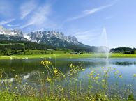
Hoppala, route niet gevonden

De door u opgevraagde pagina is niet beschikbaar. U bent welkom om een nieuwe zoekopdracht op deze pagina te starten.

0 Routes & tochten

MTB-Tour around Juffinger Jöchl

MTB-Tour around Juffinger Jöchl

A crisp, varied tour from Söll via the Lengau to Bad Häring and over the Werlberg, past the Juffinger Jöchl back to Söll. Between the individual forest sections, you are rewarded again and again with magnificent views of large parts of the Inntal valley.

Village centre, Söll (689 m)

Village centre, Söll (689 m)

Fietsen

Moeilijk

24,0 km

900 Hoogtemeters

Ellmau circular cycle trail

Ellmau circular cycle trail

Ellmau Tourist Information Office - football pitch - Ellmauer Hof - KaiserBad - Hausbach farms - Ellmau Tourist Information Office

Tourist Information Office, Ellmau (820 m)

Tourist Information Office, Ellmau (820 m)

Fietsen

Gemakkelijk

8,2 km

110 Hoogtemeters

Quellen circular route

Quellen circular route

Enjoy the scenic area of the Hohe Salve where the Söll waters originate.

Exit Keat chairlift, Söll (1,533 m)

Exit Keat chairlift, Söll (1,533 m)

Wandelen

Normaal

3:45 u

10,3 km

530 Hoogtemeters

MTB-Tour around Hohe Salve

MTB-Tour around Hohe Salve

The varied loop takes you on leisurely valley cycle paths as well as a mountain evaluation on the MTB routes 265 and 350 once around the Hohe Salve lookout mountain.

Tourismus Info, Söll

Tour

Fietsen

Normaal

36,5 km

880 Hoogtemeters

Winter hiking route Hochsöll

Winter hiking route Hochsöll

Cozy winter tour in Hochsöll with lift support, refreshments and view to the Hohe Salve.

Mountain station gondola Hexenwasser, Söll (1,150 m)

Mountain station gondola Hexenwasser, Söll (1,150 m)

Wandelen

Gemakkelijk

1:30 u

3,2 km

100 Hoogtemeters

Kaiseralm round hike

Kaiseralm round hike

Short hike from Jägerwirt to the Kaiseralm with great mountain views.

Hiking starting point Jägerwirt, Scheffau (883 m)

Hiking starting point Jägerwirt, Scheffau (883 m)

Wandelen

Gemakkelijk

1:45 u

5,0 km

250 Hoogtemeters

Ellmau circuit

Ellmau circuit
Ellmau circuit
Ellmau circuit

A beautiful easy hike at the foot of the Wilder Kaiser

Hiking starting point Tourist Info, Ellmau (800 m)

Hiking starting point Tourist Info, Ellmau (800 m)

Wandelen

Gemakkelijk

1:45 u

5,9 km

60 Hoogtemeters

Söller village tour

Söller village tour
Söller village tour
Söller village tour

Looping the village of Söll, the sight seeing hike!

Hiking starting point Tourist Info, Söll (689 m)

Hiking starting point Tourist Info, Söll (689 m)

Wandelen

Gemakkelijk

1:00 u

3,7 km

50 Hoogtemeters

Hike to Wochenbrunner Alm

Hike to Wochenbrunner Alm

Hike from the centre of Ellmau, along trail no. 14, through the "Spatlahner gorge" up to the Wochenbrunner Alm.

Hiking starting point Tourist Information Office, Ellmau (800 m)

Hiking starting point Tourist Information Office, Ellmau (800 m)

Wandelen

Gemakkelijk

1:30 u

4,4 km

285 Hoogtemeters

Prama circuit

Prama circuit
Prama circuit
Prama circuit

The Pramarunde circuit - a scenically beautiful circuit at all times of the year

Tourist Information Office, Going (766 m)

Tourist Information Office, Going (766 m)

Hardlopen

Gemakkelijk

0:30 u

4,4 km

70 Hoogtemeters

Astberg Trail

Astberg Trail
Astberg Trail
Astberg Trail

Varied beginner trail round between the Kaiser towns of Ellmau and Going.

Wanderstartplatz Tourismus Info, Ellmau

Wanderstartplatz Tourismus Info, Ellmau

Hardlopen

Gemakkelijk

10,2 km

520 Hoogtemeters

Piste tour route no. 2 - Söll

Piste tour route no. 2 - Söll
GeslotenPiste tour route no. 2 - Söll
Piste tour route no. 2 - Söll

Difficult piste tour via the downhill, route no. 40a to Hochsöll Hexenwasser mountain station & further on via the Keat downhill route no. 43 to the Keat alpine pastures.

Cable Car Söll, ski touring car park

Mountain station, Hexenwasser gondola or Keat Almen

Skitocht

Moeilijk

1:30 u

4,0 km

762 Hoogtemeters

Village tour Scheffau

Village tour Scheffau

Round tour through Scheffau with vitalising stations for refreshment and relaxation.

Hiking starting point Tourist Info, Scheffau (738 m)

Hiking starting point Tourist Info, Scheffau (738 m)

Wandelen

Gemakkelijk

1:15 u

4,3 km

90 Hoogtemeters

Hochschwendt circuit

Hochschwendt circuit

This easy family hike takes you via the Bergdoktorhaus to the Berggasthof Hochschwendt mountain inn.

Wanderstartplatz Tourist Info, Ellmau (800m)

Wanderstartplatz Tourist Info, Ellmau (800m)

Wandelen

Gemakkelijk

2:45 u

8,7 km

270 Hoogtemeters

Moon toboggan run

Moon toboggan run
Moon toboggan run
Moon toboggan run

Exciting adventure stations for family tobogganing on the Hohe Salve.

Cable car valley station, Söll (725 m)

Cable car valley station, Söll (725 m)

Rodelen

Gemakkelijk

4,0 km