


 Deutsch
 English
Römerhof winter circular hiking route
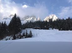
Over snow-covered meadows along the Goinger Sonnseite
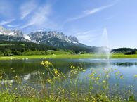
Bathing lake, Going (742 m)
Bathing lake, Going (742 m)
Wandelen
Gemakkelijk
1:30 u
3,9 km
60 Hoogtemeters
De door u opgevraagde pagina is niet beschikbaar. U bent welkom om een nieuwe zoekopdracht op deze pagina te starten.
Over snow-covered meadows along the Goinger Sonnseite
Bathing lake, Going (742 m)
Bathing lake, Going (742 m)
Wandelen
Gemakkelijk
1:30 u
3,9 km
60 Hoogtemeters

Alpine klimroutes

Dizzying experience via snack stations to the waterfall via unmanaged alpine pastures to the Hexenwasser. Return to the valley by cable car or on foot.
Hiking starting point Bergbahn, Söll (725 m)
Hiking starting point Bergbahn, Söll (725 m)
Wandelen
Normaal
2:00 u
5,6 km
500 Hoogtemeters

Short, crisp connection between the Blattlloipe and the Schwendterloipe.
Langlaufen
Normaal
0,5 km
30 Hoogtemeters

Bike tour to the idyllically situated Obere Regalm with a magnificent view.
Tourist Info, Going (764 m)
Tourist Info, Going (764 m)
Fietsen
Normaal
7,3 km
580 Hoogtemeters

The most adventurous route to the highest hut on the Wilder Kaiser.
Wochenbrunner Alm, Ellmau (1,085 m)
Wochenbrunner Alm, Ellmau (1,085 m)
Wandelen
Normaal
3:15 u
5,5 km
550 Hoogtemeters

The panoramic spot of the locals, steep and fascinating.
Hiking starting point Franzlhof, Söll (703 m)
Hiking starting point Franzlhof, Söll (703 m)
Wandelen
Normaal
5:00 u
8,5 km
880 Hoogtemeters

Alpine klimroutes
Cozy winter walk through the snowy witch water.
Mountain station gondola Hexenwasser, Söll (1,150 m)
Mountain station gondola Hexenwasser, Söll (1,150 m)
Wandelen
Gemakkelijk
0:30 u
1,2 km
45 Hoogtemeters

Comfortable round with a magnificent view of the Hohe Salve.
Mountain station gondola Hexenwasser, Söll (1,150 m)
Mountain station gondola Hexenwasser, Söll (1,150 m)
Wandelen
Gemakkelijk
0:35 u
1,8 km
50 Hoogtemeters

Gruttenhütte - Kaiser-Hochalm - Steiner-Hochalm - Hinterschießling Alm - Rehbachklamm - Scheffau, Dorf
Gruttenhütte, Ellmau (1,620 m)
Scheffau village (889 m)
Wandelen
Normaal
4:30 u
11,4 km
190 Hoogtemeters

Explore the sunny foot of the Pölven mountain.
Langlaufen
Gemakkelijk
0,9 km

2 villages - you fancy quiete and a very rural athmosphere - Scheffau is the place to go, or, you opt for a great variety of gastronomy and restaurants - then Söll is good to go. No matter how, your decision is always superb. The ski hiking route is purely flat, which also means it's great for everybody.
restaurant Oberstegen, Söll
village, Scheffau
Langlaufen
Gemakkelijk
1,4 km
15 Hoogtemeters

Pleasant circular hiking trail through forests and meadows to the romantically situated moor lake.
Hiking starting point Franzlhof, Söll (703 m)
Hiking starting point Franzlhof, Söll (703 m)
Wandelen
Normaal
2:00 u
5,7 km
240 Hoogtemeters

Round tour through Scheffau with vitalising stations for refreshment and relaxation.
Hiking starting point Tourist Info, Scheffau (738 m)
Hiking starting point Tourist Info, Scheffau (738 m)
Wandelen
Gemakkelijk
1:15 u
4,3 km
90 Hoogtemeters

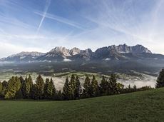
The best seat in the house for a view of the Wilder Kaiser!
Hiking starting point Going center (former tourist information Going) (764 m)
Hiking starting point Going center (former tourist information Going) (764 m)
Wandelen
Gemakkelijk
2:15 u
5,8 km
290 Hoogtemeters

Gruttenhütte - Kaiser-Hochalm - Steiner-Hochalm - Jägersteig - Walleralm - Hochegg - Kaindlhütte
Gruttenhütte, Ellmau (1,620 m)
Hintersteiner See, Scheffau (889 m)
Wandelen
Normaal
5:30 u
13,5 km
560 Hoogtemeters
From Going to the Astberg with a small altitude loop & impressive panoramic view.
Hiking starting point Going center (former tourist information Going) (764 m)
Hiking starting point Going center (former tourist information Going) (764 m)
Wandelen
Gemakkelijk
3:30 u
8,6 km
560 Hoogtemeters

Picture-postcard panoramic scenery to Hintersteiner See lake, a natural gem.
Villag Center, Söll (689 m)
Hintersteiner See Lake, Scheffau (889 m)
Fietsen
Normaal
9,4 km
430 Hoogtemeters

Stripsenjochhaus - Griesner Alm - Griesenau
Stripsenjochhaus (1,577 m)
Griesenau, Kirchdorf (719 m)
Wandelen
Normaal
3:00 u
7,9 km

Alpine klimroutes
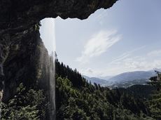
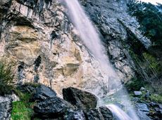
Going, Hüttling - Schleierwasserfall - Obere Regalm - Baumgartenköpfl (Bergsteigergrab) - Gaudeamushütte
Hiking starting point Hüttling, Going (820 m)
Gaudeamushütte, Going (1,263 m)
Wandelen
Normaal
4:00 u
7,3 km
860 Hoogtemeters
A beautiful easy hike at the foot of the Wilder Kaiser
Hiking starting point Tourist Info, Ellmau (800 m)
Hiking starting point Tourist Info, Ellmau (800 m)
Wandelen
Gemakkelijk
1:45 u
5,9 km
60 Hoogtemeters
Atmospheric winter hike right into the Wilder Kaiser.
Bathing lake, Going (742 m)
Graspoint-Niederalm, Going (981 m)
Wandelen
Gemakkelijk
2:30 u
5,7 km
250 Hoogtemeters

Family roundtrip through the Rebachklamm to the Seilabodenkreuz, via the Kaiseralm and the Jägerwirt back to the center of Scheffau.
Community Hall, Scheffau (740 m)
Community Hall, Scheffau (740 m)
Wandelen
Normaal
3:15 u
9,7 km
510 Hoogtemeters

60-metre high rock dome – the Mecca for extreme climbers
Sportklimmen
Circular cycling route for leisure bikers between the four villages of the Kaiser region.
anywhere along the tour
anywhere along the tour
Fietsen
Normaal
38,5 km
550 Hoogtemeters

Hike from the Kaiserlift mountain station via the Kaindlhütte and Walleralm to Hintersteiner See.
Mountain station Kaiserlift, Kufstein (1256 m)
Hiking starting point Seestüberl, Scheffau (890 m)
Wandelen
Normaal
3:20 u
8,8 km
340 Hoogtemeters

A hike on varied paths around the Achleitberg.
Hiking starting point Tourist Info, Scheffau (738 m)
Hiking starting point Tourist Info, Scheffau (738 m)
Wandelen
Normaal
5:45 u
18,0 km
540 Hoogtemeters

Alpine klimroutes

The panoramic Scheffauer is the last high peak in the west at 2,111 m above sea level.
Hiking starting point Bärnstatt, Scheffau (920 m)
Hiking starting point Bärnstatt, Scheffau (920 m)
Wandelen
Moeilijk
7:00 u
7,9 km
1180 Hoogtemeters

The Hintere Goinger Halt (2,193 m) is considered to be the easiest summit to reach in the Wilder Kaiser.
Hiking starting point Wochenbrunner Alm, Ellmau (1,085 m)
Hiking starting point Wochenbrunner Alm, Ellmau (1,085 m)
Wandelen
Moeilijk
6:30 u
8,9 km
1090 Hoogtemeters

Extended walk through the landscape of Scheffau and Söll
Hiking starting point Tourist Info, Scheffau (738 m)
Hiking starting point Tourist Info, Scheffau (738 m)
Wandelen
Gemakkelijk
3:30 u
8,8 km
210 Hoogtemeters

Peace and strength, slow down and take a deep breath.
Ahornsee car park, Söll (693 m)
Ahornsee car park, Söll (693 m)
Wandelen
Normaal
4:45 u
12,0 km
220 Hoogtemeters

Easier and more level circular walk through the sunny district of Prama for walkers or families with pushchairs.
Hiking starting point Going center (former tourist information Going) (764 m)
Hiking starting point Going center (former tourist information Going) (764 m)
Wandelen
Gemakkelijk
1:00 u
3,9 km
60 Hoogtemeters
Mountain tour to the extreme climbers’ training rock and spectacle of nature with refreshment stop at the Graspoint-Niederalm.
Hiking starting point Hüttling, Going (820 m)
Hiking starting point Hüttling, Going (820 m)
Wandelen
Normaal
3:00 u
5,5 km
520 Hoogtemeters

Easy snowshoe hike at the foot of the Wilder Kaiser.
Postbus stop Dorf/Bauhof, Ellmau
Postbus stop Dorf/Bauhof, Ellmau
Wandelen
Gemakkelijk
0:40 u
1,3 km
10 Hoogtemeters

A roundhike with family-picnic in a meadow. Tip: bring a pair of binoculars to see the chamois on the rocks.
Hiking starting point Jägerwirt, Scheffau (883 m)
Hiking starting point Jägerwirt, Scheffau (883 m)
Wandelen
Normaal
2:00 u
5,1 km
350 Hoogtemeters

Alpine klimroutes

Picturesque circular route on the sunny side of Going in unspoilt natural surroundings through snow-covered fields offering wonderful views of Going and the Wilder Kaiser region.
Hiking starting point Going center (former tourist information Going) (764 m)
Hiking starting point Going center (former tourist information Going) (764 m)
Wandelen
Gemakkelijk
1:45 u
4,8 km
80 Hoogtemeters