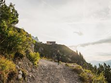
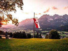
Oops, tour not found!

We are sorry, your requested page is not available. You can start a new search on this page!

0 Routes and tours

Prama circuit

Prama circuit
Prama circuit
Prama circuit

The Pramarunde circuit - a scenically beautiful circuit at all times of the year

Tourist Information Office, Going (766 m)

Tourist Information Office, Going (766 m)

Jogging

Easy

0:30 h

4,4 km

70 Elevation gain

November Sun route

November Sun route
November Sun route
November Sun route

This tour is rich in variety and includes slabs, water grooves, as well as a strong overhang and a traverse with an undercling passage.

Number of rope lengths5

Access time1,5

Alpine climbing route

Multi-rope length difficulty levels7-

Kaiserkrone - stage 2

Kaiserkrone - stage 2

Gruttenhütte - Kaiser-Hochalm - Steiner-Hochalm - Jägersteig - Walleralm - Hochegg - Kaindlhütte

Gruttenhütte, Ellmau (1,620 m)

Hintersteiner See, Scheffau (889 m)

Hiking

Intermediate

5:30 h

13,5 km

560 Elevation gain

Kaiser Marathon

Kaiser Marathon
Kaiser Marathon
Kaiser Marathon

The Kaiser Marathon - 42 km and 2,300 metres of elevation gain. A welcome challenge for our top athletes!

Söll village centre

Hohe Salve mountain

Jogging

Intermediate

42,0 km

2260 Elevation gain

Scheffau – Gruttenhütte

Scheffau – Gruttenhütte

Hike to the Gruttenhütte with great views to the Ellmauer Halt and the entire region.

Hiking starting point Tourist Info, Scheffau (738 m)

Gruttenhütte, Ellmau (1,620 m)

Hiking

Intermediate

6:30 h

16,4 km

990 Elevation gain

Sonnseit circuit (no. 14)

Sonnseit circuit (no. 14)

An adventure hike from Ellmau village centre to the Wochenbrunner Alm mountain hut from where you can enjoy stunning views and the Ellmau Stone Circle.

Hiking starting point Tourist Info, Ellmau (800 m)

Hiking starting point Tourist Info, Ellmau (800 m)

Hiking

Easy

4:30 h

13,5 km

530 Elevation gain

Circuit around Going

Circuit around Going

The circuit around Going is a lengthy and demanding tour with a great variety of different sections.

Tourist Information Office, Going (766 m)

Tourist Information Office, Going (766 m)

Jogging

Intermediate

1:25 h

11,2 km

280 Elevation gain

Schwendter Sonnenplateau circular winter hiking route

Schwendter Sonnenplateau circular winter hiking route

Picturesque circular route on the sunny side of Going in unspoilt natural surroundings through snow-covered fields offering wonderful views of Going and the Wilder Kaiser region.

Hiking starting point Going center (former tourist information Going) (764 m)

Hiking starting point Going center (former tourist information Going) (764 m)

Hiking

Easy

1:45 h

4,8 km

80 Elevation gain

Going – Gruttenhütte circular walk

Going – Gruttenhütte circular walk

A unique hike to the highest mountain hut in the Wilder Kaiser region featuring a panoramic view.

Hiking starting point Going center (former tourist information Going) (764 m)

Hiking starting point Going center (former tourist information Going) (764 m)

Hiking

Intermediate

6:00 h

14,0 km

890 Elevation gain

Asten circuit

Asten circuit
Asten circuit
Asten circuit

From Going to the Astberg with a small altitude loop & impressive panoramic view.

Hiking starting point Going center (former tourist information Going) (764 m)

Hiking starting point Going center (former tourist information Going) (764 m)

Hiking

Easy

3:30 h

8,6 km

560 Elevation gain

Bichlloipe

Bichlloipe
Bichlloipe
Bichlloipe

Cross-country skiing on an isolated plateau, surrounded by forest and winter meadows.

Cross-country skiing

Easy

1,3 km

30 Elevation gain

Kaiser crag

Kaiser crag
Kaiser crag
Kaiser crag

Along with the Murmeltierfelsen and Gamsfelsen, there are a total of 17 climbing routes of difficulty levels 3 to 6b+ near the Gaudeamushütte mountain hut.

Route number19

Access time1,0

Sport climbing

Winter wonderland

Winter wonderland
Winter wonderland
Winter wonderland

Romantic forest walk in tranquil surroundings.

Hiking starting point Tourist Info, Ellmau (800 m)

Hiking starting point Tourist Info, Ellmau (800 m)

Hiking

Easy

5:30 h

12,7 km

470 Elevation gain

Pölvenau circular route

Pölvenau circular route
Partially openPölvenau circular route
Pölvenau circular route

Pleasant circular hiking trail through forests and meadows to the romantically situated moor lake.

Hiking starting point Franzlhof, Söll (703 m)

Hiking starting point Franzlhof, Söll (703 m)

Hiking

Intermediate

2:00 h

5,7 km

240 Elevation gain

Panoramic circuit Brandstadl–Hartkaiser

Panoramic circuit Brandstadl–Hartkaiser

This familyfriendly hike leads you along the panoramic trail from the Brandstadl mountain in Scheffau to the Hartkaiser mountain in Ellmau.

Brandstadlbahn mountain station, Scheffau (1,650 m) or Hartkaiserbahn mountain station, Ellmau (1.550 m)

Brandstadlbahn mountain station, Scheffau (1,650 m) or Hartkaiserbahn mountain station, Ellmau (1.550 m)

Hiking

Easy

1:50 h

6,0 km

170 Elevation gain

Hausberg trail (no. 8)

Hausberg trail (no. 8)

Hiking trail no. 8 to the Hausberg via the Marienkapelle (St Mary’s Chapel)

Hiking starting point Tourist Information Office, Ellmau (798 m)

Brenner Alm, Ellmau (1,236 m)

Hiking

Easy

1:30 h

3,5 km

500 Elevation gain

War memorial circular route

War memorial circular route

This pleasant circular walk takes you to Söll’s war memorial in a beautiful section of forest.

Hiking starting point Tourist Info, Söll (689 m)

Hiking starting point Tourist Info, Söll (689 m)

Hiking

Easy

0:30 h

2,1 km

10 Elevation gain