


 Deutsch
 Nederlands
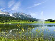
Snowcrystal circuit route

Explore the sunny foot of the Pölven mountain.
Hiking starting point Franzlhof, Söll (703 m)
Hiking starting point Franzlhof, Söll (703 m)
Hiking
Intermediate
2:30 h
6,8 km
100 Elevation gain
We are sorry, your requested page is not available. You can start a new search on this page!
Explore the sunny foot of the Pölven mountain.
Hiking starting point Franzlhof, Söll (703 m)
Hiking starting point Franzlhof, Söll (703 m)
Hiking
Intermediate
2:30 h
6,8 km
100 Elevation gain

Exciting round trip for adults and children through the Rehbach gorge.
Hiking starting point Tourist Info, Scheffau (738 m)
Hiking starting point Tourist Info, Scheffau (738 m)
Hiking
Intermediate
2:00 h
5,5 km
280 Elevation gain

Access time0,08333333333333333
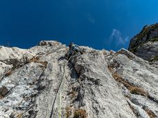
Via ferrata
Difficulty levelD-E
Via ferrara length150,0 m
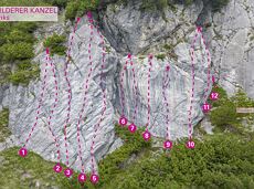
34 magnificent routes with a fantastic panoramic view of the summits.
Route number34
Access time1,5
Sport climbing
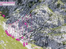
31 routes, including 14 multi-pitch.
Route number32
Access time1,5
Sport climbing

Number of rope lengths4
Access time2,0
Alpine climbing route
Multi-rope length difficulty levels7-

Experience impressive low and panoramic views in the unique rocky scenery of the legendary "Wild Castle", as this area is known according to legend thanks to its many turrets, peaks, hollows and balconies.
Wochenbrunner Alm, Ellmau (1.085 m)
Wochenbrunner Alm, Ellmau (1.085 m)
Hiking
Difficult
3:45 h
6,3 km
630 Elevation gain

Past inn, farm and chapel in the Kaiser countryside.
Hiking starting point Going Center (former Tourist informatin Going)
Hiking starting point Going Center (former Tourist informatin Going)
Cross-country skiing
Easy
1,2 km
10 Elevation gain

The circuit around Going is a lengthy and demanding tour with a great variety of different sections.
Tourist Information Office, Going (766 m)
Tourist Information Office, Going (766 m)
Jogging
Intermediate
1:25 h
11,2 km
280 Elevation gain

The classic on the Steinplatte Waidring was rehabilitated in June 2023 and is a treat for via ferrata fans! The via ferrata "s'Schuastagangl" (C/D) offers wonderful panoramic views, crisp ascents and unforgettable mountain moments. The varied tour leads through steep rock faces and slippery passages up to the summit of the Waidringer Steinplatte (1,848m). Strength for steeper ascents and courage for ladder passages and the "Knieschloderer" variant with airy steps and a rope bridge are required!
Access time0,3333333333333333
Via ferrata
Difficulty levelC-D
Via ferrara length220,0 m
Over snow-covered meadows along the Goinger Sonnseite
Bathing lake, Going (742 m)
Bathing lake, Going (742 m)
Hiking
Easy
1:30 h
3,9 km
60 Elevation gain

mountain station Salvistabahn / Kleine Salve
Middle station Salvistabahn Itter
Hiking
Intermediate
2:45 h
7,4 km
360 Elevation gain

Cross-country skiing in imperial style with two options: moderately challenging or just for pleasure.
Cross-country skiing
Easy
5,5 km
50 Elevation gain

Ancient path of the romans - a better stroll.
Hiking starting point Tourist Info, Söll (689 m)
Hiking starting point Tourist Info, Söll (689 m)
Hiking
Easy
1:00 h
3,0 km
55 Elevation gain

A crisp, varied tour from Söll via the Lengau to Bad Häring and over the Werlberg, past the Juffinger Jöchl back to Söll. Between the individual forest sections, you are rewarded again and again with magnificent views of large parts of the Inntal valley.
Village centre, Söll (689 m)
Village centre, Söll (689 m)
Cycling
Difficult
24,0 km
900 Elevation gain

Extended walk through the landscape of Scheffau and Söll
Hiking starting point Tourist Info, Scheffau (738 m)
Hiking starting point Tourist Info, Scheffau (738 m)
Hiking
Easy
3:30 h
8,8 km
210 Elevation gain

Ellmau Tourist Information Office - golf course - Wochenbrunner Alm
Tourist Information Office, Ellmau (800 m)
Wochenbrunner Alm, Ellmau (1,085 m)
Cycling
Intermediate
4,8 km
260 Elevation gain

Winter hike with picturesque views of the Wilder Kaiser to the 'Wolfsegg' plateau
Hiking starting point Going center (former tourist information Going) (764 m)
Hiking starting point Going center (former tourist information Going) (764 m)
Hiking
Easy
1:30 h
4,0 km
65 Elevation gain

The best seat in the house for a view of the Wilder Kaiser!
Tourist Information Office, Going (766 m)
Tourist Information Office, Going (766 m)
Cycling
Intermediate
2:00 h
7,5 km
350 Elevation gain

A moderately challenging panoramic circuit around the Astberg mountain.
Tourist Info, Going (764 m)
Tourist Info, Going (764 m)
Cycling
Intermediate
15,3 km
480 Elevation gain

The Pramarunde circuit - a scenically beautiful circuit at all times of the year
Tourist Information Office, Going (766 m)
Tourist Information Office, Going (766 m)
Jogging
Easy
0:30 h
4,4 km
70 Elevation gain

Ideal circuit for beginners to start exercising
Tourist Information Office, Going (766 m)
Tourist Information Office, Going (766 m)
Jogging
Easy
0:20 h
3,1 km
75 Elevation gain

There are 3 steep rises which are moderable with e-bikes.
Cable car valley station, Söll (725 m)
Au Hoch-Alm, Söll (1.600 m)
Cycling
Intermediate
8,9 km
860 Elevation gain

A unique hike to the highest mountain hut in the Wilder Kaiser region featuring a panoramic view.
Hiking starting point Going center (former tourist information Going) (764 m)
Hiking starting point Going center (former tourist information Going) (764 m)
Hiking
Intermediate
6:00 h
14,0 km
890 Elevation gain

Varied beginner trail round between the Kaiser towns of Ellmau and Going.
Wanderstartplatz Tourismus Info, Ellmau
Wanderstartplatz Tourismus Info, Ellmau
Jogging
Easy
10,2 km
520 Elevation gain

From Hochsöll (Hexenwasser theme park) and Filzalmsee lake to Brixen im Thale.
Hexenwasser theme park Söll Hohe Salve
Brixen im Thale valley station
Cycling
Intermediate
9,3 km
200 Elevation gain

Above Lake Reintal in Kramsach. Easy to reach, perfect infrastructure (parking, lake for bathing, restaurants, buses) and short access route; indescribably beautiful views over the lakes and the Lower Inn Valley. For experienced climbers!
Via ferrata

Cross-country skiing on an isolated plateau, surrounded by forest and winter meadows.
Cross-country skiing
Easy
1,3 km
30 Elevation gain

Wild and free - 5 days of hiking on old paths around the Wilder Kaiser The five-day hike from hut to hut is one of the most beautiful multi-day circular tours in Tirol. It takes mountain walkers along a route of around 58 kilometres, featuring ascents and descents with a difference in altitude of approximately 4,000 metres as they circle around the imposing Wilder Kaiser massif.
Hiking starting point Hüttling, Going (820 m)
Hiking starting point Hüttling, Going (820 m)
Hiking
Intermediate
27 h
57,7 km
4000 Elevation gain

With the Söller Zehner (1st competition in the Tour de Tirol) the circuit is run three times!
Hiking starting point Tourist Info, Söll (689 m)
Hiking starting point Tourist Info, Söll (689 m)
Jogging
Easy
3,3 km
80 Elevation gain

On the north side up to the Ellmauer Halt summit 2,344 m.
Access time4,5
Via ferrata
Difficulty levelB-C
Via ferrara length2000,0 m

An adventure hike from Ellmau village centre to the Wochenbrunner Alm mountain hut from where you can enjoy stunning views and the Ellmau Stone Circle.
Hiking starting point Tourist Info, Ellmau (800 m)
Hiking starting point Tourist Info, Ellmau (800 m)
Hiking
Easy
4:30 h
13,5 km
530 Elevation gain

Peace and strength, slow down and take a deep breath.
Ahornsee car park, Söll (693 m)
Ahornsee car park, Söll (693 m)
Hiking
Intermediate
4:45 h
12,0 km
220 Elevation gain

Cozy winter tour in Hochsöll with lift support, refreshments and view to the Hohe Salve.
Mountain station gondola Hexenwasser, Söll (1,150 m)
Mountain station gondola Hexenwasser, Söll (1,150 m)
Hiking
Easy
1:30 h
3,2 km
100 Elevation gain

Snowshoe hike via the Kaiseralmen with starting and finishing at the Gasthof Jägerwirt.
Gasthof Jägerwirt, Scheffau (883 m)
Gasthof Jägerwirt, Scheffau (883 m)
Hiking
Intermediate
3:15 h
4,8 km
250 Elevation gain
Hike to the Hexenwasser and get rewarded with a view.
Bergbahn valley station, Söll (724 m)
Bergbahn valley station, Söll (724 m)
Hiking
Easy
3:00 h
7,9 km
410 Elevation gain

Stripsenjochhaus - Griesner Alm - Griesenau
Stripsenjochhaus (1,577 m)
Griesenau, Kirchdorf (719 m)
Hiking
Intermediate
3:00 h
7,9 km
A beautiful easy hike at the foot of the Wilder Kaiser
Hiking starting point Tourist Info, Ellmau (800 m)
Hiking starting point Tourist Info, Ellmau (800 m)
Hiking
Easy
1:45 h
5,9 km
60 Elevation gain
Number of rope lengths10
Access time1,5
Alpine climbing route
Multi-rope length difficulty levels6

The panoramic Scheffauer is the last high peak in the west at 2,111 m above sea level.
Hiking starting point Bärnstatt, Scheffau (920 m)
Hiking starting point Bärnstatt, Scheffau (920 m)
Hiking
Difficult
7:00 h
7,9 km
1180 Elevation gain