


 Deutsch
 Nederlands
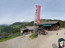
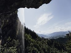
Übungsklettersteige Stripsenjoch

This 3-part Via Ferrata features a rope bridge and an extremely difficult exit option.
Via ferrata
Length160,0 m
We are sorry, your requested page is not available. You can start a new search on this page!
This 3-part Via Ferrata features a rope bridge and an extremely difficult exit option.
Via ferrata
Length160,0 m

Beautiful circular walk around the frozen Lake Hinterstein.
Hiking starting point Seestüberl, Scheffau (890 m)
Hiking starting point Seestüberl, Scheffau (890 m)
Hiking
Easy
2:00 h
5,7 km
70 Elevation gain

On the north side up to the Ellmauer Halt summit 2,344 m.
Access time4,5
Via ferrata
Difficulty levelB-C
Via ferrara length2000,0 m

Family roundtrip through the Rebachklamm to the Seilabodenkreuz, via the Kaiseralm and the Jägerwirt back to the center of Scheffau.
Community Hall, Scheffau (740 m)
Community Hall, Scheffau (740 m)
Hiking
Intermediate
3:15 h
9,7 km
510 Elevation gain

Wonderful winter hike on the sunny side of the valley and easy return to the starting point by bus.
Hiking starting point Tourist Information Office, Ellmau (800 m)
Hiking starting point Tourist Information Office, Scheffau (737 m)
Hiking
Easy
2:15 h
6,1 km
40 Elevation gain

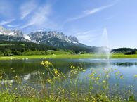
Picture-postcard panoramic scenery to Hintersteiner See lake, a natural gem.
Villag Center, Söll (689 m)
Hintersteiner See Lake, Scheffau (889 m)
Cycling
Intermediate
9,4 km
430 Elevation gain

From the Bergdoktorhaus to the Rübezahl-Alm mountain hut and the Carved Figures path to Ellmi’s Zauberwelt.
Hiking starting point Tourist Info, Ellmau (800 m)
Hiking starting point Tourist Info, Ellmau (800 m)
Hiking
Easy
5:30 h
15,8 km
730 Elevation gain

Short circular walk at the snow-white Brandstadl mountain with panorama view.
Brandstadlbahn summit station, Scheffau (1,643 m)
Brandstadlbahn summit station, Scheffau (1,643 m)
Hiking
Easy
0:30 h
1,3 km
40 Elevation gain

The short via ferrata is ideal for beginners.
Access time0,9166666666666666
Via ferrata
Difficulty levelB-C
Via ferrara length50,0 m

Pure adrenaline is the motto of the Pölven trail on the third day of the Tour de Tirol
Hiking starting point Tourist Info, Söll (689 m)
Hiking starting point Tourist Info, Söll (689 m)
Jogging
Intermediate
24,2 km
1260 Elevation gain

Moderately difficult ascent route along the ski route 80c/d to the Hartkaiser.
Hartkaiserbahn valley station, Ellmau (824 m)
Hartkaiserbahn mountain station, Ellmau (1.524 m)
Ski tour
Intermediate
2:30 h
4,2 km
700 Elevation gain

Cross-country skiing on an isolated plateau, surrounded by forest and winter meadows.
Cross-country skiing
Easy
1,3 km
30 Elevation gain

This well-secured sport climbing route features interesting lines in prime rock.
Number of rope lengths9
Access time2,0
Alpine climbing route
Multi-rope length difficulty levels8+
Following the Stampfangerbach stream on the way to Filzalm lake
Hiking starting point Bergbahn, Söll (725 m)
Hiking starting point Bergbahn, Söll (725 m)
Hiking
Intermediate
3:15 h
9,0 km
620 Elevation gain

Pleasant high-altitude walk taking in the mountain and Astbergsee lake - the mirror of the Wilder Kaiser!
Blattlalm, Going (1,246 m)
Blattlalm, Going (1,246 m)
Hiking
Easy
0:40 h
1,7 km
80 Elevation gain

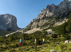
The Hintere Goinger Halt (2,193 m) is considered to be the easiest summit to reach in the Wilder Kaiser.
Hiking starting point Wochenbrunner Alm, Ellmau (1,085 m)
Hiking starting point Wochenbrunner Alm, Ellmau (1,085 m)
Hiking
Difficult
6:30 h
8,9 km
1090 Elevation gain

Turnoff to Granderalm – Schleier Waterfall – Going, Hüttling
First turnoff after the Granderalm
Hiking starting point Hüttling, Going (820 m)
Hiking
Intermediate
2:00 h
3,1 km
40 Elevation gain

Energy trail with seven stations offering refreshing and relaxing experiences.
Hiking starting point Tourist Info, Scheffau (738 m)
Hiking starting point Tourist Info, Scheffau (738 m)
Hiking
Easy
0:45 h
2,3 km
70 Elevation gain
A must for hikers in Söll - local history and culinary delights on the sunny side.
Hiking starting point Franzlhof, Söll (703 m)
Hiking starting point Franzlhof, Söll (703 m)
Hiking
Easy
4:00 h
12,0 km
420 Elevation gain

A winter hiking route connects the villages of Söll and Scheffau.
Hiking starting point Tourist Info, Scheffau (737 m)
Hiking starting point Tourist Info, Söll (689 m)
Hiking
Intermediate
2:45 h
7,1 km
70 Elevation gain

Walk through the forest, along the river, back to the village.
Hiking starting point Tourist Info, Söll (689 m)
Hiking starting point Tourist Info, Söll (689 m)
Hiking
Easy
1:45 h
6,3 km
90 Elevation gain
A beautiful easy hike at the foot of the Wilder Kaiser
Hiking starting point Tourist Info, Ellmau (800 m)
Hiking starting point Tourist Info, Ellmau (800 m)
Hiking
Easy
1:45 h
5,9 km
60 Elevation gain

Easier and more level circular walk through the sunny district of Prama for walkers or families with pushchairs.
Hiking starting point Going center (former tourist information Going) (764 m)
Hiking starting point Going center (former tourist information Going) (764 m)
Hiking
Easy
1:00 h
3,9 km
60 Elevation gain

Pleasant circular hiking trail through forests and meadows to the romantically situated moor lake.
Hiking starting point Franzlhof, Söll (703 m)
Hiking starting point Franzlhof, Söll (703 m)
Hiking
Intermediate
2:00 h
5,7 km
240 Elevation gain

Very demanding round tour to the two eastern peaks in the Wilder Kaiser.
Hiking starting point Tannbichl, Going (857 m)
Hiking starting point Tannbichl, Going (857 m)
Hiking
Difficult
9:00 h
13,0 km
1570 Elevation gain

Enjoy winter silence and an imperial panorama in Söll.
parking area Ahornsee, Söll (693 m)
parking area Ahornsee, Söll (693 m)
Cross-country skiing
Intermediate
5,3 km
80 Elevation gain
Wilder Kaiser hike to a series of special locations. Featuring the natural spectacle of the Schleier Waterfall and a view of the Gaudeamushütte mountain hut.
Hüttling, Going (820 m)
Hüttling, Going (820 m)
Hiking
Intermediate
6:00 h
13,6 km
980 Elevation gain

Gentle cycle tour from Wörgl via Söll, Scheffau, Ellmau and Going to St. Johann or vice versa!
Wörgl (511 m)
St. Johann (660 m)
Cycling
Intermediate
38,2 km
450 Elevation gain

Cozy winter tour in Hochsöll with lift support, refreshments and view to the Hohe Salve.
Mountain station gondola Hexenwasser, Söll (1,150 m)
Mountain station gondola Hexenwasser, Söll (1,150 m)
Hiking
Easy
1:30 h
3,2 km
100 Elevation gain

Hike to the Gaudeamushütte mountain hut by the Wilder Kaiser
Wochenbrunner Alm, Ellmau (1,085 m)
Gaudeamushütte, Going (1,263 m)
Hiking
Easy
0:35 h
1,3 km
200 Elevation gain

Gaudeamushütte – Gamswegl – path 825 – Gruttenhütte
Gaudeamushütte, Going (1,263 m)
Gruttenhütte, Ellmau (1,620 m)
Hiking
Intermediate
1:45 h
3,2 km
480 Elevation gain

Baumgartenköpfl (Bergsteigergrab) – Wilder-Kaiser-Steig – Jubiläumssteig – Gruttenhütte
Brennender Palven (1,572 m)
Gruttenhütte, Ellmau (1,620 m)
Hiking
Difficult
2:30 h
3,3 km
410 Elevation gain

This familyfriendly hike leads you along the panoramic trail from the Brandstadl mountain in Scheffau to the Hartkaiser mountain in Ellmau.
Brandstadlbahn mountain station, Scheffau (1,650 m) or Hartkaiserbahn mountain station, Ellmau (1.550 m)
Brandstadlbahn mountain station, Scheffau (1,650 m) or Hartkaiserbahn mountain station, Ellmau (1.550 m)
Hiking
Easy
1:50 h
6,0 km
170 Elevation gain

Head through well-shaded forests of green to reach the Ellmau Stone Circle. This is a place with a special energy, making it an inviting option for taking some time to relax.
Hiking starting point Wochenbrunner Alm, Ellmau (1,085 m)
Hiking starting point Wochenbrunner Alm, Ellmau (1,085 m)
Hiking
Intermediate
1:00 h
2,4 km
120 Elevation gain

Wochenbrunner Alm – Gruttenhühtte
Hiking starting point Wochenbrunner Alm, Ellmau (1,085 m)
Gaudeamushütte, Going (1,263 m)
Hiking
Intermediate
1:45 h
2,6 km
530 Elevation gain

Short hike from Jägerwirt to the Kaiseralm with great mountain views.
Hiking starting point Jägerwirt, Scheffau (883 m)
Hiking starting point Jägerwirt, Scheffau (883 m)
Hiking
Easy
1:45 h
5,0 km
250 Elevation gain
Going, Hüttling - Schleierwasserfall - Obere Regalm - Baumgartenköpfl (Bergsteigergrab) - Gaudeamushütte
Hiking starting point Hüttling, Going (820 m)
Gaudeamushütte, Going (1,263 m)
Hiking
Intermediate
4:00 h
7,3 km
860 Elevation gain

The Pramarunde circuit - a scenically beautiful circuit at all times of the year
Tourist Information Office, Going (766 m)
Tourist Information Office, Going (766 m)
Jogging
Easy
0:30 h
4,4 km
70 Elevation gain

From Hochsöll (Hexenwasser theme park) and Filzalmsee lake to Brixen im Thale.
Hexenwasser theme park Söll Hohe Salve
Brixen im Thale valley station
Cycling
Intermediate
9,3 km
200 Elevation gain

Explore the sunny foot of the Pölven mountain.
Hiking starting point Franzlhof, Söll (703 m)
Hiking starting point Franzlhof, Söll (703 m)
Hiking
Intermediate
2:30 h
6,8 km
100 Elevation gain