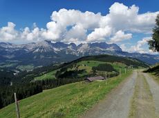
Oops, tour not found!

We are sorry, your requested page is not available. You can start a new search on this page!

0 Routes and tours

MTB-Tour around Juffinger Jöchl

MTB-Tour around Juffinger Jöchl

A crisp, varied tour from Söll via the Lengau to Bad Häring and over the Werlberg, past the Juffinger Jöchl back to Söll. Between the individual forest sections, you are rewarded again and again with magnificent views of large parts of the Inntal valley.

Village centre, Söll (689 m)

Village centre, Söll (689 m)

Cycling

Difficult

24,0 km

900 Elevation gain

Rauher Kopf

Rauher Kopf
ClosedRauher Kopf
Rauher Kopf

Over hill and dale through idyllic nature up to the Rauhen Kopf.

Astberg Bergstation

Astberg Bergstation

Hiking

Intermediate

4:45 h

13,1 km

620 Elevation gain

Hartkaiser circuit (no. 1 & 3)

Hartkaiser circuit (no. 1 & 3)

From the Bergdoktorhaus to the Rübezahl-Alm mountain hut and the Carved Figures path to Ellmi’s Zauberwelt.

Hiking starting point Tourist Info, Ellmau (800 m)

Hiking starting point Tourist Info, Ellmau (800 m)

Hiking

Easy

5:30 h

15,8 km

730 Elevation gain

Ellmau Stone Circle circuit

Ellmau Stone Circle circuit

Head through well-shaded forests of green to reach the Ellmau Stone Circle. This is a place with a special energy, making it an inviting option for taking some time to relax.

Hiking starting point Wochenbrunner Alm, Ellmau (1,085 m)

Hiking starting point Wochenbrunner Alm, Ellmau (1,085 m)

Hiking

Intermediate

1:00 h

2,4 km

120 Elevation gain

Kaiser circular cycling route

Kaiser circular cycling route

Calling bike fans of all ability levels! The Kaiser circular cycling route is an 80-kilometre bike route through the spectacular scenery of the Kaisergebirge mountain range. An excellent network of well-signposted trails (a mix of asphalt and gravel paths) leads past idyllic nature, breathtaking panoramas and cultural sights. For relaxing moments in between stages, cool lakes and local restaurants invite you to linger and enjoy.

anywhere along the tour

anywhere along the tour

Cycling

Intermediate

83,0 km

700 Elevation gain

Circuit around Going

Circuit around Going

The circuit around Going is a lengthy and demanding tour with a great variety of different sections.

Tourist Information Office, Going (766 m)

Tourist Information Office, Going (766 m)

Jogging

Intermediate

1:25 h

11,2 km

280 Elevation gain

Pölven Bike Tour

Pölven Bike Tour
Pölven Bike Tour
Pölven Bike Tour

A beautiful bike tour with moderate and short climbs araound the striking Pölven mountain.

anywhere along the tour

anywhere along the tour

Cycling

Easy

29,6 km

420 Elevation gain

Kaiserkrone - stage 2

Kaiserkrone - stage 2

Gruttenhütte - Kaiser-Hochalm - Steiner-Hochalm - Jägersteig - Walleralm - Hochegg - Kaindlhütte

Gruttenhütte, Ellmau (1,620 m)

Hintersteiner See, Scheffau (889 m)

Hiking

Intermediate

5:30 h

13,5 km

560 Elevation gain

Hartkaiser circuit Ellmau

Hartkaiser circuit Ellmau

Hartkaiserbahn summit station - Ellmis Zauberwald - Tanzbodensee lake - Hartkaiserbahn summit station

Hartkaiser summit station, Ellmau (1,555 m)

Hartkaiser summit station, Ellmau (1,555 m)

Jogging

Easy

3,4 km

120 Elevation gain

Pölvenau circular route

Pölvenau circular route
Partially openPölvenau circular route
Pölvenau circular route

Pleasant circular hiking trail through forests and meadows to the romantically situated moor lake.

Hiking starting point Franzlhof, Söll (703 m)

Hiking starting point Franzlhof, Söll (703 m)

Hiking

Intermediate

2:00 h

5,7 km

240 Elevation gain

Eagle Walk Tirol

Eagle Walk Tirol
Eagle Walk Tirol
Eagle Walk Tirol

Hikers exploring Tirol on foot will feel as free as a bird. The eagle walk is one of the 'Great Walks' of Tyrol chosen by a jury. They offer hikers the chance to get away from it all, discover the beauty of nature and experience a true adventure in the Alps.

St. Johann in Tirol

Arlbergpass

Hiking

Difficult

413,0 km

31000 Elevation gain

Quellen circular route

Quellen circular route

Enjoy the scenic area of the Hohe Salve where the Söll waters originate.

Exit Keat chairlift, Söll (1,533 m)

Exit Keat chairlift, Söll (1,533 m)

Hiking

Intermediate

3:45 h

10,3 km

530 Elevation gain

Kaiserkrone - around the Wilder Kaiser in 5 days

Kaiserkrone - around the Wilder Kaiser in 5 days

Wild and free - 5 days of hiking on old paths around the Wilder Kaiser The five-day hike from hut to hut is one of the most beautiful multi-day circular tours in Tirol. It takes mountain walkers along a route of around 58 kilometres, featuring ascents and descents with a difference in altitude of approximately 4,000 metres as they circle around the imposing Wilder Kaiser massif.

Hiking starting point Hüttling, Going (820 m)

Hiking starting point Hüttling, Going (820 m)

Hiking

Intermediate

27 h

57,7 km

4000 Elevation gain

Panoramic circuit Brandstadl–Hartkaiser

Panoramic circuit Brandstadl–Hartkaiser

This familyfriendly hike leads you along the panoramic trail from the Brandstadl mountain in Scheffau to the Hartkaiser mountain in Ellmau.

Brandstadlbahn mountain station, Scheffau (1,650 m) or Hartkaiserbahn mountain station, Ellmau (1.550 m)

Brandstadlbahn mountain station, Scheffau (1,650 m) or Hartkaiserbahn mountain station, Ellmau (1.550 m)

Hiking

Easy

1:50 h

6,0 km

170 Elevation gain